
Morningside is a southside suburb in the City of Brisbane, Queensland, Australia. In the 2021 census, Morningside had a population of 11,755 people.

Archerfield Airport is a leased federal airport located in Archerfield, 11–12 km (6.8–7.5 mi) to the south of Brisbane, Queensland, Australia. For some time, it was the primary airport in Brisbane, but it is now the secondary airport. During World War II, it was used as a Royal Australian Air Force station. Airport traffic peaked in the 1980s. In December 2010, a development plan was released for public comment and included a new parallel runway.

Toowong is a riverside suburb in the City of Brisbane, Queensland, Australia. In the 2021 census, Toowong had a population of 12,556 people. It is predominantly a middle-class area (67.8%), with a median weekly household income of $1,930.

Acacia Ridge is a southern suburb in the City of Brisbane, Queensland, Australia. In the 2016 census, Acacia Ridge had a population of 7,429 people.

Tingalpa is a suburb in the City of Brisbane, Queensland, Australia. In the 2016 census, Tingalpa had a population of 8,290 people.
Lutwyche is a northern suburb in the City of Brisbane, Queensland, Australia. In the 2016 census, Lutwyche had a population of 3,454 people.

Kedron is a northern suburb in the City of Brisbane, Queensland, Australia. In the 2016 census, Kedron had a population of 9,359 people. It is home to the Queensland Fire and Emergency Services headquarters.

Brookfield is a rural residential suburb in the City of Brisbane, Queensland, Australia. In the 2021 census, Brookfield had a population of 3,640 people.

Goodna is a suburb on the eastern edge of the City of Ipswich in Queensland, Australia. In the 2016 census, Goodna had a population of 10,461 people.

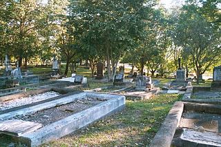
Toowong Cemetery is a heritage-listed cemetery on the corner of Frederick Street and Mt Coot-tha Road, Toowong, City of Brisbane, Queensland, Australia. It was established in 1866 and formally opened in 1875. It is Queensland's largest cemetery and is located on forty-four hectares of land at the corner of Frederick Street and Mount Coot-tha Road approximately four and a half kilometres west of Brisbane. It was previously known as Brisbane General Cemetery. It was added to the Queensland Heritage Register on 31 December 2002.

Nudgee is a north-eastern suburb in the City of Brisbane, Queensland, Australia. In the 2016 census, Nudgee had a population of 3,578 people.

Hemmant is a suburb of the City of Brisbane, Queensland, Australia. In the 2016 census, Hemmant had a population of 2,385 people.

Archerfield is a mixed-use southern suburb in the City of Brisbane, Queensland, Australia. In the 2016 census, Archerfield had a population of 544 people.

Salisbury is a southern suburb in the City of Brisbane, Queensland, Australia. In the 2021 census, Salisbury had a population of 6,790 people.

Richlands is an outer south-western suburb in the City of Brisbane, Queensland, Australia. In the 2016 census, Richlands had a population of 3,598 people.

Nundah Cemetery is a heritage-listed cemetery at 88 Hedley Avenue, Nundah, City of Brisbane, Queensland, Australia. It was built from 1840s to 1963. It is also known as German Station Cemetery. It was added to the Queensland Heritage Register on 21 October 1992.
South Brisbane Cemetery, also known as Dutton Park Cemetery, is a heritage-listed cemetery at 21 Fairfield Road and Annerley Road, Dutton Park, City of Brisbane, Queensland, Australia, adjacent to the Brisbane River. It was built from 1870 to 1990s. It was added to the Queensland Heritage Register on 1 October 2003.
Balmoral Cemetery is a major cemetery in Morningside, Brisbane, Queensland, Australia. The cemetery has also been known as Bulimba Cemetery, Morningside Cemetery and Kangaroo Point Cemetery.

Archerfield Second World War Igloos Complex is a heritage-listed group of hangars at 98-138 Kerry Road, Archerfield Airport, Archerfield, City of Brisbane, Queensland, Australia. They were built from February 1943 February to circa April 1944 by the Allied Works Council. They were also known as Hastings Deering (Australia) Ltd premises and Thiess Contractors Pty Ltd premises. They were added to the Queensland Heritage Register on 27 August 1999.

Kingston Pioneer Cemetery is a heritage-listed cemetery at Bega Road, Kingston, City of Logan, Queensland, Australia. It was built from 1896 to 1941. It was added to the Queensland Heritage Register on 26 May 2000.


