The Nelson River is a river of north-central North America, in the Canadian province of Manitoba. The river drains Lake Winnipeg and runs 644 kilometres (400 mi) before it ends in Hudson Bay. Its full length is 2,575 kilometres (1,600 mi), it has mean discharge of 2,370 cubic metres per second (84,000 cu ft/s), and has a drainage basin of 1,072,300 square kilometres (414,000 sq mi), of which 180,000 square kilometres (69,000 sq mi) is in the United States.

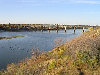
The Saskatchewan River is a major river in Canada. It stretches about 550 kilometres (340 mi) from where it is formed by the joining together of the North Saskatchewan River and South Saskatchewan River just east of Prince Albert, Saskatchewan, to Lake Winnipeg. It flows roughly eastward across Saskatchewan and Manitoba to empty into Lake Winnipeg. Through its tributaries the North Saskatchewan and South Saskatchewan, its watershed encompasses much of the prairie regions of Canada, stretching westward to the Rocky Mountains in Alberta and north-western Montana in the United States.

The Assiniboine River is a 1,070-kilometre (660 mi) river that runs through the prairies of Western Canada in Saskatchewan and Manitoba. It is a tributary of the Red River. The Assiniboine is a typical meandering river with a single main channel embanked within a flat, shallow valley in some places and a steep valley in others. Its main tributaries are the Qu'Appelle, Souris, and Whitesand Rivers. For early history and exploration see Assiniboine River fur trade.

The Kenogami River is a river in the James Bay drainage basin in Thunder Bay and Cochrane districts in Northern Ontario, Canada, which flows north from Long Lake near Longlac to empty into the Albany River. The river is 320 kilometres (199 mi) in length and its name means "long water" in the Cree language. A portion of the river's headwaters have been diverted into the Lake Superior drainage basin.

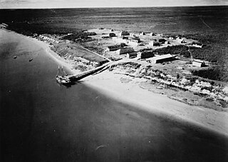
The Hayes River is a river in Northern Manitoba, Canada, that flows from Molson Lake to Hudson Bay at York Factory. It was historically an important river in the development of Canada and is now a Canadian Heritage River and the longest naturally flowing river in Manitoba.

Island Lake is a lake in northeastern Manitoba in Canada, near the Ontario border. The lake covers a total area of 1,223 square kilometres (472 sq mi), making it the 6th largest lake in the province. The lake is in the Hayes River drainage basin. The Island Lake River flows north from the northwest section of the lake into Gods Lake via Goose Lake and Beaver Lake. Gods Lake drains north through Gods River into the Hayes River.
Gods Lake is a lake in northeastern Manitoba in Canada. The lake covers an area of 1,151 square kilometres (444 sq mi) with a net area of 1,061 square kilometres (410 sq mi), making it the 7th largest lake in the province. It lies north of Island Lake at an elevation of 178 metres (584 ft), approximately 280 kilometres (174 mi) east of Thompson, Manitoba. It has a shore length of 474 kilometres (295 mi). It drains north via the Gods River and the Hayes River to Hudson Bay.
The Berens River is a river in the provinces of Manitoba and Ontario, Canada. It flows west from an unnamed lake in Kenora District, Ontario, and discharges its waters into Lake Winnipeg near the community and First Nation of Berens River, Manitoba. The river has a number of lakes along its course, and many rapids.
The Sturgeon River is a river in the Hudson Bay drainage basin in Manitoba and Ontario, Canada. It flows west from its source in Unorganized Kenora District, Northwestern Ontario, through Sturgeon Lake, and takes in the right tributary Hayhurst River just before reaching its mouth at the Echoing River in Northern Region, Manitoba. The Echoing River flows via the Gods River and the Hayes River to Hudson Bay.
The Bolton River is a river in the Hudson Bay drainage basin in Census Division No. 22 - Thompson-North Central, Northern Region, Manitoba, Canada. It is about 115 kilometres (71 mi) long and begins at Musketasonan Lake, about 20 kilometres (12 mi) south of Molson Lake, at an elevation of 249 metres (817 ft). It flows northeast through Little Bolton Lake at an elevation of 224 metres (735 ft), Rushforth Lake at an elevation of 218 metres (715 ft), Bolton Lake at an elevation of 212 metres (696 ft), where it takes in the right tributary Nikik River, and Kakwusis Lake at an elevation of 208 metres (682 ft). The river continues northeast over the twin Kasukwapiskechewak Rapids, then over the twin Kakwu Rapids, and empties into Aswapiswanan Lake at an elevation of 186 metres (610 ft), about 60 kilometres (37 mi) west southwest of the community of Gods Lake Narrows. The Bolton River's waters eventually flow into Gods Lake, and via the Gods River and the Hayes River into Hudson Bay.
Aswapiswanan Lake is a lake in the Hayes River drainage basin in Census Division No. 22 - Thompson-North Central, Northern Region, Manitoba, Canada. The lake is about 22 kilometres (14 mi) long and 2.6 kilometres (1.6 mi) wide and lies at an elevation of 186 metres (610 ft). The primary inflows from west to east are the Hungry River, Porcupine Creek, the Bolton River and the Joint River. The primary outflow is the Mink River. The lake's waters eventually flow into Gods Lake, and via the Gods River and the Hayes River into Hudson Bay.
Musketasonan Lake is a lake in the Hayes River drainage basin in Census Division No. 22 - Thompson-North Central, Northern Region, Manitoba, Canada. The lake is about 4.5 kilometres (2.8 mi) long and 1.6 kilometres (1.0 mi) wide and lies at an elevation of 249 metres (817 ft). It is the source of the Bolton River, whose waters eventually flow into Gods Lake, and via the Gods River and the Hayes River into Hudson Bay.
Touchwood Lake is a lake in the Hayes River drainage basin in Census Division No. 22 - Thompson-North Central, Northern Region, Manitoba, Canada. The lake is about 20.9 kilometres (13.0 mi) long and 4.4 kilometres (2.7 mi) wide and lies at an elevation of 184 metres (604 ft). The primary inflows are the Mink River, Wanless Creek, and the Wapawukaw River, and the primary outflow is a channel to Vermilyea Lake. The lake's waters eventually flow into Gods Lake, and via the Gods River and the Hayes River into Hudson Bay.
Vermilyea Lake is a lake in the Hayes River drainage basin in Census Division No. 22 — Thompson-North Central, Northern Region, Manitoba, Canada. It is shaped like the letter "L" on its side, is about 9.3 kilometres (5.8 mi) long and 8.2 kilometres (5.1 mi) wide, and lies at an elevation of 184 metres (604 ft). The primary inflow is a channel from Touchwood Lake, and the primary outflows are the twin channels of the Wesachewan River to Gods Lake. The lake's waters eventually flow via the Gods River and the Hayes River into Hudson Bay.
The Wesachewan River is a short river in the Hudson Bay drainage basin in census division No. 22 of Northern Manitoba, Canada.
Little Bolton Lake is a lake in the Hayes River drainage basin in Census Division No. 22 - Thompson-North Central, Northern Region, Manitoba, Canada. The lake is about 15 kilometres (9.3 mi) long and 4 kilometres (2.5 mi) wide and lies at an elevation of 224 metres (735 ft). The primary inflow and outflow is the Bolton River, whose waters eventually flow into Gods Lake, and via the Gods River and the Hayes River into Hudson Bay.
Bolton Lake is a lake in the Hayes River drainage basin in Census Division No. 22 - Thompson-North Central, Northern Region, Manitoba, Canada. The lake is at an elevation of 212 metres (696 ft); the main body of the lake is about 15 kilometres (9.3 mi) long and 8 kilometres (5.0 mi) wide, but an arm extends a further 11 kilometres (6.8 mi) for a total width of 19 km as well. The primary inflows are the Bolton River from the west and the Nikik River from the south, and the primary outflow is Bolton River, whose waters eventually flow into Gods Lake, and via the Gods River and the Hayes River into Hudson Bay.
Kakwusis Lake is a lake in the Hayes River drainage basin in Census Division No. 22 - Thompson-North Central, Northern Region, Manitoba, Canada. The lake is about 3.6 kilometres (2.2 mi) long and 1.6 kilometres (1.0 mi) wide and lies at an elevation of 208 metres (682 ft). The primary inflow and outflow is the Bolton River, whose waters eventually flow into Gods Lake, and via the Gods River and the Hayes River into Hudson Bay.
The Echoing River is a river in the Hudson Bay drainage basin in Manitoba and Ontario, Canada. Its flows from its source at Echoing Lake in the unorganized part of Kenora District, Northwestern Ontario to its mouth as a right tributary of the Gods River in Northern Manitoba. The Gods River flows via the Hayes River to Hudson Bay.
The Wolf River is a river in census division No. 22 in Manitoba, Canada. It is in the Hudson Bay drainage basin and is a right tributary of the Hayes River.


