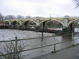
Richmond Lock and Footbridge is a lock, rising and falling low-tide barrage integrating controlled sluices and pair of pedestrian bridges on the River Thames in southwest London, England, and is a Grade II* listed structure. It is the furthest downstream of the forty-five Thames locks and the only one owned and operated by the Port of London Authority. It was opened in 1894 and is north-west of the centre of Richmond in a semi-urban part of southwest London. Downstream are Syon Park and Kew Gardens on opposite banks. It connects the promenade at Richmond with the neighbouring district of St. Margarets on the west bank during the day and is closed at night to pedestrians – after 19:30 GMT or after 21:30 when BST is in use. At high tide the sluice gates are raised and partly hidden behind metal arches forming twin footbridges.

The Little Avon River is a small river partly in southern Gloucestershire and partly in South Gloucestershire. For much of its length it forms the boundary between the county of Gloucestershire and the unitary authority of South Gloucestershire. It rises to the east of Wickwar, near Horton, passes near Charfield, Stone and Berkeley, and enters the River Severn via Berkeley Pill. It was formerly navigable up to moorings at Berkeley, but a flood-prevention scheme, built in the 1960s, now prevents navigation more than a few hundred metres upstream.

Radcot Bridge is a crossing of the Thames in England, south of Radcot, Oxfordshire, and north of Faringdon, Oxfordshire which is in the district of that county that was in Berkshire. It carries the A4095 road across the reach above Radcot Lock. In many analyses it is a series of three bridges – before the northern one is reached, mainly to the east, is the smaller island hosting the Swan Inn. On the main north bank are slight earthworks forming a large square in which further remains have been found of Matilda's Castle and some Roman artefacts.

Cookham Lock is a lock with weirs situated on the River Thames near Cookham, Berkshire, about a half-mile downstream of Cookham Bridge. The lock is set in a lock cut which is one of four streams here and it is surrounded by woods. On one side is Sashes Island and on the other is Mill Island connected to Formosa Island, the largest on the non-tidal Thames.
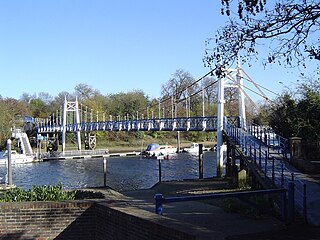
The Teddington Lock Footbridges are two footbridges over the River Thames in England, situated just upstream of Teddington Lock at Teddington. There is a small island between the bridges.

Folly Bridge is a stone bridge over the River Thames carrying the Abingdon Road south from the centre of Oxford, England. It was erected in 1825–27, to designs of a little-known architect, Ebenezer Perry, who practised in London.

Godstow is about 2.5 miles (4 km) northwest of the centre of Oxford. It lies on the banks of the River Thames between the villages of Wolvercote to the east and Wytham to the west. The ruins of Godstow Abbey, also known as Godstow Nunnery, are here. A bridge spans the Thames and the Trout Inn is at the foot of the bridge across the river from the abbey ruins. There is also a weir and Godstow lock.

Hambleden Mill is an historic watermill on the River Thames at Mill End, near the village of Hambleden in Buckinghamshire, England. It is linked by a footbridge to Hambleden Lock, which is on the Berkshire side of the river. It was Grade II listed in 1955 and has now been converted into flats. Alongside the mill is Hambleden Marina which occupies two islands. Along the river frontage to the south-east is the site of a Roman Villa.

St John's Lock, below the town of Lechlade, Gloucestershire, is the furthest upstream lock on the River Thames in England. The name of the lock derives from a priory that was established nearby in 1250, but which no longer exists. The lock was built of stone in 1790 by the Thames Navigation Commission.

Benson Lock is a lock on the River Thames in England, close to Benson, Oxfordshire but on the opposite bank of the river. The first pound lock here was built by the Thames Navigation Commission in 1788 and it was replaced by the present masonry lock in 1870. The distance between Benson Lock and Cleeve Lock downstream is 6.5 miles (10.4 km) - the longest distance between locks on the River Thames.

Staines Bridge is a road bridge running in a south-west to north-east direction across the River Thames in Surrey. It is on the modern A308 road and links the boroughs of Spelthorne and Runnymede at Staines-upon-Thames and Egham Hythe. The bridge is Grade II listed.

Osney Lock is a lock on the River Thames in Oxford, England, where the village or island of Osney is next to the river.

Godstow Lock is a lock on the River Thames in Oxfordshire, England. It is between the villages of Wolvercote and Wytham on the outskirts of Oxford. The first lock was built of stone by Daniel Harris for the Thames Navigation Commission in 1790. It is the lock furthest upstream on the river which has mechanical (electro-hydraulic) operation - every lock upstream of Godstow utilises manual beam operation instead.

King's Lock is a lock on the River Thames in England. It is in open country to the north of Oxford, Oxfordshire, on the southern bank of the river. The lock was one of the last pound locks built on the Thames, built by the Thames Conservancy in 1928 to replace the former flash lock. It has the smallest fall of any lock on the river, 0.77 m.

Water Eaton House Bridge is a footbridge across the River Thames in Wiltshire, England. It straddles the parishes of Cricklade and Castle Eaton near Water Eaton House and is between the heart of both villages, Cricklade being a small town to many. It is on the Thames Path.

St John's Bridge is a two-section road bridge across the channel of the upper Thames near Lechlade, England, then across the lock cut to the south, the highest lock on the Thames. It is a Grade II listed building.

Tadpole Bridge is a road bridge across the River Thames in Oxfordshire, England, carrying a road between Bampton to the north and Buckland to the south. It crosses the Thames on the reach above Shifford Lock. It is a Grade II listed building. The bridge dates from the late 18th century, the earliest reference to it being in 1784. It is built of stone, and consists of one large arch. There is a public house near Tadpole Bridge called The Trout. Thacker noted that at one time the legend over the door read "The Trout, kept by A. Herring". The Trout is now a hotel and gastropub. The Thames Path crosses Tadpole Bridge.
Duke's Cut is a short waterway in Oxfordshire, England, which connects the Oxford Canal with the River Thames via the Wolvercote Mill Stream. It is named after George Spencer, 4th Duke of Marlborough, across whose land the waterway was cut. It is seen as a branch of the Oxford Canal.


