
Otsego County is a county in the U.S. state of New York. As of the 2010 census, the population was 62,259. The county seat is Cooperstown. The name Otsego is from a Mohawk or Oneida word meaning "place of the rock."
Hartwick is a town located in Otsego County, New York, United States. As of the 2010 census, the town had a population of 2,110. The Town of Hartwick is located in the middle of the county, southwest of the Village of Cooperstown.

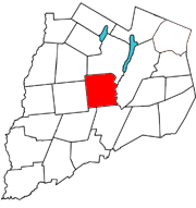
Otsego is a town in the north-central part of Otsego County, New York, United States. The population was 3,900 at the 2010 census. The town is named after Lake Otsego, which forms part of the town's eastern border.

Laurens is a town in Otsego County, New York, United States. The population was 2,424 at the 2010 census.

Milford is a town in Otsego County, New York, United States. The population was 3,044 at the 2010 census. Within town is the village of Milford. The town is northeast of the City of Oneonta.
New York State Route 28 (NY 28) is a state highway extending for 281.69 miles (453.34 km) in the shape of a "C" between the Hudson Valley city of Kingston and southern Warren County in the U.S. state of New York. Along the way, it intersects several major routes, including Interstate 88 (I-88), U.S. Route 20 (US 20), and the New York State Thruway twice. The southern terminus of NY 28 is at NY 32 in Kingston and the northern terminus is at US 9 in Warrensburg. In Kingston, NY 28 is co-designated as Interstate 587 from its southern terminus at NY 32 to the roundabout linking it to the Thruway (I-87).

Otsego Lake is a 4,046-acre (16.37 km2) lake located in Otsego County in the U.S. State of New York. It is the source of the Susquehanna River and largest lake in Otsego County. The Village of Cooperstown is located at the lake's southern end. Glimmerglass State Park is located on the lake's northeastern shore, and includes Hyde Hall, a large mansion constructed in 1817 that overlooks the lake. Glimmerglass Opera is located on the western shore.

Canadarago Lake is a 1,917-acre (7.76 km2) lake located in Otsego County, New York and is the source of Oaks Creek. The Village of Richfield Springs is located at the lake's northern end. It is the second largest lake in Otsego County, lying to the west of and parallel to the larger Otsego Lake. The lake's name is also spelled "Candajarago Lake" or "Caniadaraga Lake".

Fishkill Creek is a tributary of the Hudson River in Dutchess County, New York, United States. At 33.5 miles (53.9 km) it is the second longest stream in the county, after Wappinger Creek. It rises in the town of Union Vale and flows generally southwest to a small estuary on the Hudson just south of Beacon. Part of its 193-square-mile (500 km2) watershed is in Putnam County to the south. Sprout Creek, the county's third-longest creek, is its most significant tributary. Whaley and Sylvan lakes and Beacon Reservoir, its largest, deepest and highest lakes, are among the bodies of water within the watershed.
New York State Route 23 (NY 23) is an east–west state highway in the eastern portion of New York in the United States. It extends for 156.15 miles (251.30 km) from an intersection with NY 26 in the Central New York town of Cincinnatus to the Massachusetts state line in the Berkshire Mountains, where it continues east as that state's Route 23. Along the way, it passes through many communities, including the cities of Norwich and Oneonta. Outside of the communities, the route serves largely rural areas of the state and traverses the Catskill Mountains in the state's Central New York Region. NY 23 crosses the Hudson River at Catskill via the Rip Van Winkle Bridge.

New York State Route 357 (NY 357) is a 14.02-mile-long (22.56 km) state highway in New York, running from NY 7 in the Otsego County village of Unadilla to NY 28 in the Delaware County town of Franklin.
New York State Route 205 (NY 205) is a 23.24-mile-long (37.40 km) north–south state highway in central Otsego County, New York, in the United States. It extends from Interstate 88 (I-88) at exit 13 near the city of Oneonta to a junction with NY 28 and NY 80 in the town of Otsego. The latter junction also marks the east end of a 2.1-mile (3.4 km) overlap between NY 205 and NY 80, from where NY 80 heads southeast to follow NY 28 to Cooperstown. NY 205 is a two-lane highway for its entire length and passes through the towns of Oneonta, Laurens and Hartwick.

New York State Route 166 (NY 166) is a north–south state highway in Otsego County, New York, in the United States. It extends for 20.96 miles (33.73 km) from NY 28 in the village of Milford to U.S. Route 20 (US 20) north of the village of Cherry Valley. Much of NY 166's southern portion is near Cooperstown, and various county routes serve as connectors between NY 166 and Cooperstown. In Cherry Valley, NY 166 intersects the former western terminus of the First Great Western Turnpike. After passing under US 20, the road continues as County Route 32, which becomes County Route 82 at the Montgomery County line, north to Sprout Brook in Montgomery County, where it meets NY 163. NY 166 is a two-lane highway its entire length.

County Route 18 (CR 18) is a county-maintained highway in western Otsego County, New York, in the United States. It extends for 34.83 miles (56.05 km) from an intersection with New York State Route 51 (NY 51) in the town of Butternuts to the Oneida County line at Plainfield, where it becomes CR 2. The highway runs along the eastern bank of the Unadilla River and parallels NY 8, which follows the western bank of the river. CR 18 enters the vicinity of several villages and hamlets, including the village of New Berlin and the hamlet of Unadilla Forks.

Robert V. Riddell State Park is a 2,163-acre (8.75 km2) state park in Otsego and Delaware counties, New York. The park is located approximately 20 miles (32 km) from Cooperstown.

Oaks Creek is a river that drains Canadarago Lake, which is situated in the north central region of Otsego County, New York. The creek begins by the Hamlet of Schuyler Lake and flows southeast approximately 9.32 miles (15.00 km), dropping only 105 feet (32 m) in elevation, before converging with the Susquehanna River south of the Village of Cooperstown, by the Hamlet of Index. From the source to Oaksville the creek flows along Panther Mountain. Fly Creek is a main tributary, that converges with Oaks Creek south of the Hamlet of Fly Creek.

Allen Lake is a lake located southeast of the Village of Richfield Springs in northern Otsego County, New York. It is a natural lake, but a low earthen dam and concrete spillway were installed to raise the lake level. The main outflow is Trout Brook, also known as White Creek, which flows into Otsego Lake. Allen Lake is the water supply for Richfield Springs.

The Canajoharie Creek is a river that flows into the Mohawk River in the Village of Canajoharie in the U.S. State of New York. The name "Canajoharie" is a Mohawk language term meaning "the pot that washes itself", referring to the "Canajoharie Boiling Pot", a 20-foot (6.1 m) wide and 10-foot (3.0 m) deep pothole in the Canajoharie Creek, just south of the village of Canajoharie. Bowmans Creek is one main tributary that enters the creek east of the Hamlet of Sprout Brook. The other main tributary is Brimstone Creek which enters the creek north-northwest of the Village of Ames.

Goodyear Lake is a man-made lake created by the building of the Colliersville Dam. The lake is located southwest of the hamlet of Portlandville in the Town of Milford in Otsego County, New York.
