Gold Strike Hot Springs

Last updated

Gold Strike Hot Springs
Goldstrike Hot Springs
Nevada Hot Springs
Gold Strike Canyon Hot Springs
Canyoneering in hot spring water (30766262623).jpg
Canyoneering by rope in hot spring water
Gold Strike Hot Springs
Locationnear Boulder City, Arizona/Nevada border
Coordinates 35°59′58″N114°44′33″W / 35.9994°N 114.7425°W / 35.9994; -114.7425
Elevation1,561 feet
Type Geothermal spring water seeps in cliff face
Temperature109°F

Gold Strike Hot Springs, also known as Goldstrike Hot Springs, Nevada Hot Springs and Gold Strike Canyon Hot Springs are a group of hot springs near Hoover Dam on the Arizona/Nevada border near historic Boulder City. [1] They are in the Lake Mead National Recreation Area.

Contents

History

Indigenous people used hot springs throughout the American Southwest for thousands of years, based on archaeological evidence of human use and settlement by Paleo-Indians. Thermal springs provided warmth, healing mineral water, and cleansing. [2]

Geology and geography

The geothermally heated spring water seeps out of the cliffs in Gold Strike Canyon, and collects in a series of primitive rock soaking pools. [3] The series of collecting pools go for approximately two miles along the canyon. [3] The canyon has been known for flash floods. [1] The pluton is exposed in Gold Strike Canyon, with volcanic breccias, multiple faults and dike intrusions. The hot springs emanate from the termination of the Palm Tree fault, where it meets the Salt Cedar fault zone. The spring discharge is abundant and includes gypsum encrustations and a carbonate spring mound. [4] This fault zone is significant, as it is the area where there are significant changes in the isotopic and chemical make up of the groundwater discharged in the springs. [4]

The hike to the hot springs is difficult and requires technical equipment such as ropes and ascending and descending gear. [5] There have been a number of fatalities (mostly from heat exposure) in the Canyon, including two hikers who died on one day in June 2003. [6] Although the trail was previously open year-round, in 2016 the National Park Service closed the trail in summer months (generally May 15 – Sept. 30) due to dangers from extreme heat. [7] To reach the hot springs from the trail, one encounters a series of eight difficult rope descents. After the descent, hikers reach a series of hot spring soaking pools, hot waterfalls and grottos. [1]

Water profile

The water emerges from the cliffs at 109 °F (43 °C), and as they collect in the pools, the temperatures range from 98 to 110 °F (37 to 43 °C). [3] Near the first waterfall on the trail is a sand and gravel-bottomed rock pool at 100 °F (38 °C). [3]

Location

The springs are located on the Arizona/Nevada border at an elevation of 1,561 feet (476 m). [8] [9]

See also

Related Research Articles

<span class="mw-page-title-main">Long Valley Caldera</span> Geologic depression near Mammoth Mountain, California, United States

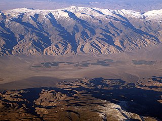
Long Valley Caldera is a depression in eastern California that is adjacent to Mammoth Mountain. The valley is one of the Earth's largest calderas, measuring about 20 mi (32 km) long (east-west), 11 mi (18 km) wide (north-south), and up to 3,000 ft (910 m) deep.

<span class="mw-page-title-main">Pagosa Springs, Colorado</span> Town in Colorado, United States

Pagosa Springs is a home rule municipality that is the county seat, the most populous community, and the only incorporated municipality in Archuleta County, Colorado, United States. The population was 1,571 at the 2020 census. Approximately 65 percent of the land in Archuleta County is either San Juan National Forest, Weminuche and South San Juan wilderness areas, or Southern Ute Indian reservation land.

<span class="mw-page-title-main">Geothermal areas of Yellowstone</span> Geyser basins and other geothermal features in Yellowstone National Park

The geothermal areas of Yellowstone include several geyser basins in Yellowstone National Park as well as other geothermal features such as hot springs, mud pots, and fumaroles. The number of thermal features in Yellowstone is estimated at 10,000. A study that was completed in 2011 found that a total of 1,283 geysers have erupted in Yellowstone, 465 of which are active during an average year. These are distributed among nine geyser basins, with a few geysers found in smaller thermal areas throughout the Park. The number of geysers in each geyser basin are as follows: Upper Geyser Basin (410), Midway Geyser Basin (59), Lower Geyser Basin (283), Norris Geyser Basin (193), West Thumb Geyser Basin (84), Gibbon Geyser Basin (24), Lone Star Geyser Basin (21), Shoshone Geyser Basin (107), Heart Lake Geyser Basin (69), other areas (33). Although famous large geysers like Old Faithful are part of the total, most of Yellowstone's geysers are small, erupting to only a foot or two. The hydrothermal system that supplies the geysers with hot water sits within an ancient active caldera. Many of the thermal features in Yellowstone build up sinter, geyserite, or travertine deposits around and within them.

<span class="mw-page-title-main">Lake Mohave</span> Reservoir on the Colorado River

Lake Mohave is a reservoir on the Colorado River between the Hoover Dam and Davis Dam in Cottonwood Valley defining the border between Nevada and Arizona in the United States. This 67 mile stretch of the Colorado River flows past Boulder City, Nelson, Searchlight, Cottonwood Cove, Cal-Nev-Ari, and Laughlin to the west in Nevada and Willow Beach and Bullhead City to the east in Arizona. A maximum width of 4 miles wide and an elevation of 647 feet (197 m), Lake Mohave encompasses 28,260 acres of water. As Lake Mead lies to the north of the Hoover Dam, Lake Mohave and adjacent lands forming its shoreline are part of the Lake Mead National Recreation Area administered by the U.S. National Park Service.

<span class="mw-page-title-main">Scovern Hot Springs</span> Former settlement in California, United States

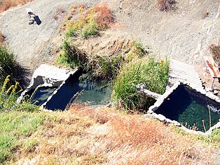
Scovern Hot Springs is a thermal spring system, and former settlement in the Kern River Valley of the Southern Sierra Nevada, in Kern County, California.

<span class="mw-page-title-main">Beppu Onsen</span> Hot spring system in Japan

Beppu Onsen (別府温泉) is an extensive hot spring system in the city of Beppu, Ōita, Japan. There are eight distinct major thermal spring zones called "Beppu Hatto".

<span class="mw-page-title-main">Guadalupe Canyon</span> Geographic feature in Arizona, New Mexico, and Sonora

Guadalupe Canyon is a canyon and valley in the southern portion of the Peloncillo Mountains Hidalgo County, New Mexico, Cochise County, Arizona and Agua Prieta Municipality, of Sonora. The waters of Guadalupe Canyon are tributary to the San Bernardino River joining it at its mouth at 31°13′33″N109°16′10″W just below Dieciocho de Augusto, Sonora. Its source is at 31°28′08″N109°02′21″W at an elevation of 6,160 feet on the south slope of Guadalupe Mountain. It crosses the border into Mexico at 31°19′57″N109°05′19″W at an elevation of 4,173 feet / 1,272 meters.

<span class="mw-page-title-main">Pagosa hot springs</span> Thermal spring

Pagosa hot springs is a hot spring system located in the San Juan Basin of Archuleta County, Colorado. The town of Pagosa Springs claim they are the world's deepest known geothermal hot springs.

<span class="mw-page-title-main">Arizona (Ringbolt) Hot Springs</span> Thermal spring

Arizona (Ringbolt) Hot Springs, also known as simply Ringbolt Hot Springs or Arizona Hot Springs, is a group of three geothermal springs located near Hoover Dam, Arizona. They are located on the Lake Mead National Recreation Area.

<span class="mw-page-title-main">Fish Lake Hot Well</span> Thermal spring

Fish Lake Hot Well, also known as Fish Lake Hot Spring and Fish Lake Valley Hot Well is a geothermal hot spring in Nevada.

<span class="mw-page-title-main">Chena Hot Springs (thermal mineral springs)</span> Thermal springs

Chena Hot Springs are a system of thermal mineral springs located within the Yukon-Tanana Plateau near the town of Chena Hot Springs, approximately 50 miles northeast of Fairbanks, Alaska.

<span class="mw-page-title-main">Penny Hot Springs</span> Thermal spring

Penny Hot Springs is a geothermal spring located near the historic mining town of Redstone, Colorado.

<span class="mw-page-title-main">Conundrum Hot Springs</span> Thermal springs

Conundrum Hot Springs is a geothermal spring in a remote section of the Maroon Bells-Snowmass Wilderness area of the White River National Forest in Colorado Rocky Mountains.

<span class="mw-page-title-main">Rogers Warm Spring</span> Geothermal spring

Rogers Warm Spring is a geothermal spring located in Clark County, Nevada near the town of Overton.

<span class="mw-page-title-main">Crystal Springs hot springs</span> Thermal spring

Crystal Springs hot springs is a system of geothermal springs and seeps near Ash Springs, located at the site of a ghost town, Crystal Springs, Nevada. Several marshes and springs are located along the White River.

<span class="mw-page-title-main">Jordan Hot Springs</span> Thermal spring

Jordan Hot Springs is series of thermal mineral springs located in the Golden Trout Wilderness, Inyo National Forest, California.

<span class="mw-page-title-main">Big Caliente Hot Springs</span> Thermal springs

Big Caliente Hot Springs are a grouping of thermal mineral springs located in the Los Padres National Forest of California.

<span class="mw-page-title-main">Truth or Consequences Hot Springs</span> Thermal springs system

Truth or Consequences Hot Springs is a thermal spring system located in the Hot Springs Artesian Basin area of Truth or Consequences, New Mexico in Sierra County.

Hot Well Dunes is a hot spring in the San Simeon Valley of Arizona, located on BLM land southeast of the town of Safford.

References

  1. 1 2 3 "Gold Strike Hot Spring". Travel Nevada. Archived from the original on March 3, 2020. Retrieved March 3, 2020.
  2. "A History of Geothermal Energy in America". U.S. Department of Energy Efficiency and Renewable Energy. Archived from the original on November 2, 2020. Retrieved November 1, 2020.
  3. 1 2 3 4 Gersh-Young, Marjorie (2010). Hot Springs and Hot Pools of the Southwest. Santa Cruz, California: Aqua Thermal. p. 125. ISBN   978-1-890880-09-5.
  4. 1 2 Beard, L. Sue; Anderson, Zachary W.; Felger, Tracy J.; Seixas, Gustav B. Geologic Framework of Thermal Springs, Black Canyon, Nevada and Arizona (PDF). United States Geological Survey in cooperation with the National Park Service. Archived (PDF) from the original on May 12, 2021. Retrieved March 3, 2020.
  5. Jones, Jay (April 11, 2019). "Time's running out to hike this amazing hot springs trail near Las Vegas". Los Angeles Times. Archived from the original on December 23, 2019. Retrieved March 4, 2020.
  6. "2 hikers die from exposure to heat". Las Vegas Sun. June 19, 2003. Archived from the original on March 13, 2023. Retrieved January 22, 2021.
  7. "Goldstrike Canyon, Arizona Hot Spring Trails Will Close May 15 – Sept 30". National Park Service. Archived from the original on January 28, 2021. Retrieved January 22, 2021.
  8. "Goldstrike Hot Springs Trail". All Trails. Archived from the original on March 3, 2020. Retrieved March 3, 2020.
  9. "The Hiking Project". Archived from the original on March 3, 2020. Retrieved March 3, 2020.