Slavko Avsenik was a Slovene composer and musician. Beginning in 1953 with the formation of the Avsenik Brothers Ensemble, Avsenik produced more than 1,000 songs and garnered success both in Slovenia and in other parts of Europe and America, and is viewed as a Slovenian cultural icon.
In the minds of many foreigners, Slovenian folk music means a form of polka that is still popular today, especially among expatriates and their descendants. However, there are many styles of Slovenian folk music beyond polka and waltz. Kolo, lender, štajeriš, mafrine and šaltin are a few of the traditional music styles and dances.

The Karawanks or Karavankas or Karavanks are a mountain range of the Southern Limestone Alps on the border between Slovenia to the south and Austria to the north. With a total length of 120 kilometres (75 mi) in an east–west direction, the Karawanks chain is one of the longest ranges in Europe. It is traversed by important trade routes and has a great tourist significance. Geographically and geologically, it is divided into the higher Western Karawanks and the lower-lying Eastern Karawanks. It is traversed by the Periadriatic Seam, separating the Apulian tectonic plate from the Eurasian Plate.
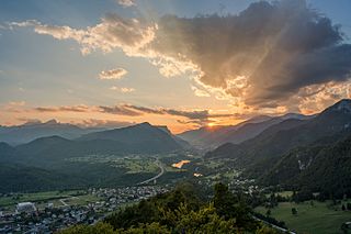
Jesenice is the tenth-largest town in Slovenia, located in the traditional province of Upper Carniola. It is the seat of the Municipality of Jesenice spanning the southern side of the Karawanks, along Slovenia's border with Austria to the north. Renowned as a mining town, its ironworks and metallurgy industries being the driving force of the town's historical development.
Rateče is a village in the Municipality of Kranjska Gora, in the far northwest corner of Slovenia. It is located in the upper part of the Upper Sava Valley, between the Sava Dolinka and Ziljica rivers, a tributary of the Drava. Further up the valley is the Rateče border crossing to Italy. Rateče is the closest Slovenian village to the summit of Mount Peč, the point where the borders of Austria, Italy, and Slovenia meet.

Slovene culture is the culture of the Slovenes, a south Slavic ethnic group. It is incredibly diverse for the country's small size, spanning the southern portion of Central Europe, being the melting pot of Slavic, Germanic and Romance cultures while encompassing parts of the Eastern Alps, the Pannonian Basin, the Balkan Peninsula and the Mediterranean.

Stol or Hochstuhl, at 2,236 m (7,336 ft), is the highest mountain of the Karawanks and straddles the border between Slovenia and Austria.

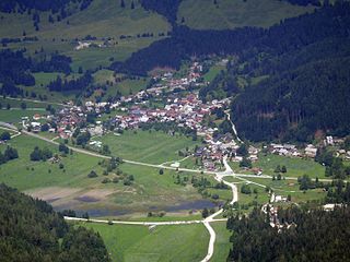
Planina pod Golico is a mountain village in the Municipality of Jesenice, in the Upper Carniola region of Slovenia. It lies on the southern foot of Mount Golica in the Karawanks range, at an elevation of 954 metres (3,130 ft).
Rožca is a grassy high-elevation mountain pass over the western Karawanks. The saddle is located between Hrušica Peak and Mount Klek, and straddles the border between Slovenia and Austria, above the town of Jesenice. Its slopes serve as sheep pastures.
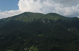
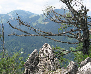
Klek, also known as Petelin or Petelinjek to locals from the villages on the Slovene side below its summit, is a peak in the Western Karawanks, between Golica/Kahlkogel to the east and Dovška Baba to the west. It lies on the border between Slovenia and Austria above the town of Jesenice. On the northern side towards Carinthia the peak itself is very steep and mostly composed of brittle rock and scree, and is accessible from Rosenbach on the Austrian side only via Rožca Saddle. Due to their inaccessibility, its northern slopes are known for their alpine flora, particularly the protected edelweiss. It is more easily accessible from the Slovene side from Planina pod Golico.
Hrušica is a settlement 3 kilometres (1.9 mi) west of Jesenice along the main road to Kranjska Gora in the Municipality of Jesenice in the Upper Carniola region of Slovenia.

Koroška Bela is a settlement in the Municipality of Jesenice in northwestern Slovenia. The village has long been a center of iron mining and processing; until recently a majority of its inhabitants were employed in the steel industry.

Toško Čelo is a dispersed settlement on the slope of the hill known as Tošč Face, part of the Polhov Gradec Hills, west of the capital Ljubljana in central Slovenia. The area is part of the traditional region of Upper Carniola and is now included with the rest of the municipality in the Central Slovenia Statistical Region. It belongs to the City Municipality of Ljubljana.
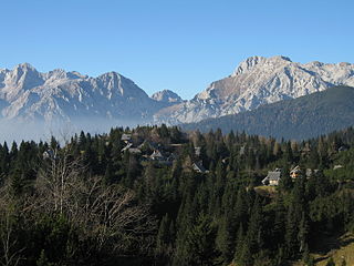
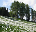
The Big Pasture Plateau is a karstified mountain plateau in the Kamnik–Savinja Alps northeast of Kamnik, Slovenia. It measures 5.8 square kilometres and has an average elevation of 1,500 metres above sea level. Its highest point is Mount Gradišče, at 1,666 m (5,466 ft). There are numerous herders' dwellings that comprise several settlement areas: Velika Planina 'Big Pasture', Mala Planina 'Little Pasture', Gojška Planina 'Gozd Pasture', Tiha Dolina 'Quiet Valley', and others. The Big Pasture Plateau is a tourist destination both in winter as a ski resort and in summer as a place for relaxation.
Na Golici is a Slovenian polka instrumental composed by Slavko Avsenik (1929-2015) and arranged by his brother Vilko Ovsenik. The song was written in 1954 and first recorded in January 1955 in the Radio Kärnten (Carinthia) studio in Klagenfurt, Austria. It is considered the most played instrumental tune in the world. At this time, the band was renamed to Gorenjski kvintet. This song has been covered more than 600 times all over the world.

Mount Saint Mary, originally known as Holm, is an inselberg in the north of Ljubljana, the capital of Slovenia. The mountain is part of the city's Šmarna Gora District. It is the highest hill in the city and a popular hiking destination.

The Zirbitzkogel, at 2,396 m (AA), is the highest point of the Seetal Alps in Austria. It lies south of the Upper Mur valley in the Styria near its border with Carinthia. The Lavant, a left tributary of the Drau, has its source on the southern slopes of the mountain.
The Slovenian Mountain Hiking Trail, sometimes also called Transverzala, is a route from Maribor to Ankaran. It covers most of the Slovenian mountain areas including Pohorje, the Julian Alps, the Kamnik-Savinja Alps, the Karawanks, and the southwestern part of Slovenia. It is the oldest hiking track in Europe.

Begunjščica is a ridge mountain in the Karawanks. It rises from the western Smokuč mountain pasture to St. Anne on its eastern side. The mountain has three main peaks, the highest being Big Peak. The western Middle Peak lies a little lower, and the lowest is Begunje Mount Vrtača. Its southern slopes rise over the Draga Valley. The ascent of the mountain is relatively easy and possible throughout the year. In the winter and early spring conditions are favourable for ski touring.

Avsenik Brothers Ensemble were a Slovene Oberkrainer music band formed by the brothers Slavko Avsenik and Vilko Avsenik in 1953 in Begunje na Gorenjskem. The music for their repertoire of about 1000 songs was all written by Slavko and arranged by Vilko, an academic composer. Lyrics for their songs were written by Marjan Stare, Ferry Souvan, Ivan Sivec, Franc Košir, Tone Fornezzi, Vinko Šimek and others.