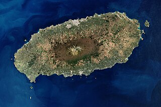
Jeju Island is South Korea's largest island, covering an area of 1,833.2 km2 (707.8 sq mi), which is 1.83% of the total area of the country. Alongside outlying islands, it is part of Jeju Province.

Cheonmasan (Korean: 천마산) is a mountain in Gyeonggi Province, South Korea. It can be found within the boundaries of the city of Namyangju. Cheonmasan has an elevation of 810.2 m (2,658 ft).
Doilbong (Korean: 도일봉) is a mountain in Gyeonggi-do, South Korea. It is located within the boundaries of Yangpyeong County. Doilbong has an elevation of 864 m (2,835 ft).
Seounsan is a mountain in South Korea. Its area extends across the city of Anseong, Gyeonggi Province and Jincheon County, North Chungcheong Province. It has an elevation of 547.7 m (1,797 ft). Seounsan translates as "West Clouds Mountain". The Cheongryongsa or "Blue Dragon Temple" is located on the Southern slope of the mountain.
Amisan is a mountain in the county of Hongcheon, Gangwon-do in South Korea. It has an elevation of 960.8 m (3,152 ft).
Baegunsan is a mountain between the provinces of Gangwon-do and North Chungcheong Province in South Korea. Its area extends into the cities of Wonju and Jecheon. It has an elevation of 1,085.7 m (3,562 ft).
Cheongoksan (Korean: 청옥산) is a mountainous in the province of Gangwon-do, South Korea. Its area extends across the counties of Jeongseon and Pyeongchang. Cheongoksan has an elevation of 1,255.7 m (4,120 ft).
Daemisan is a mountain in the county of Pyeongchang, Gangwon-do in South Korea. It has an elevation of 1,243.4 m (4,079 ft).
Eungbongsan (Korean: 응봉산) is a mountain that sits on the border Samcheok, Gangwon-do and Uljin County, North Gyeongsang Province, in South Korea. It has an elevation of 999 m (3,278 ft).
Gyejoksan (Korean: 계족산) is a mountain in the county of Yeongwol, Gangwon-do in South Korea. It has an elevation of 889.6 m (2,919 ft). This mountain has the Red Clay Trail, an eco-healing walking path that is located atop the first mountain in the country with a barefoot walking theme.
Eungbongsan (Korean: 응봉산) is a mountain in Hongcheon county, Gangwon-do, in South Korea. It has an elevation of 1,103.3 m (3,620 ft).
Eungbongsan (Korean: 응봉산) is a mountain in the county of Yeongwol, Gangwon-do, in South Korea. It has an elevation of 1,013 m (3,323 ft).
Masan is a mountain in the county of Goseong, Gangwon-do in South Korea.
Cheonghwasan (Korean: 청화산) is a mountain between the county of Goesan, North Chungcheong Province and the city of Sangju, North Gyeongsang Province, South Korea. It has an elevation of 984 m (3,228 ft).

Taesŏngsan (Korean: 대성산) is a mountain in Taesong-guyok, Pyongyang, North Korea. It has an elevation of 270 metres (890 ft). One popular visitor attraction on Taesŏngsan is the outdoor ice rink. Others include the Revolutionary Martyrs' Cemetery and the Korea Central Zoo.
Amisan (아미산) is a mountain of Dangjin, Chungcheongnam-do, South Korea. It has an elevation of 349 metres (1,145 ft).

Maisan (Korean: 마이산) is a mountain of Jeollabuk-do, western South Korea. It has an elevation of 686 metres.
Muryongsan is a mountain of North Jeolla Province, western South Korea. It has an elevation of 1,492 metres (4,895 ft).

Bohyeonsan or Bohyeon Mountain or Mount Bohyeon is located in the province of North Gyeongsang Province, eastern South Korea. Its peak has an elevation of 1,121 metres (3,678 ft), and is near the city of Yeongcheon.

Seonginbong (성인봉) is a mountain located on the South Korean island of Ulleungdo, in North Gyeongsang Province, off the eastern coast of the mainland Korean Peninsula. It is the tallest mountain on the island and has an elevation of 984 metres.


