Goodwood Island is an island situated between the main channel of the Clarence River and the river's north Arm near Iluka and Woombah, New South Wales Australia. It has a large wharf at the Port of Yamba where ocean traders collect cargo to take to New Zealand, Lord Howe Island and Norfolk Island.
The island is home to a museum, called the Shed Gallery, which features photographs and other objects related to the sugar industry in northern New South Wales. [1]

The Tweed River is a river situated in the Northern Rivers district of New South Wales, Australia. It has a mature wave dominated, barrier estuary. From the middle reaches of its course, the state boundary between New South Wales and Queensland is located approximately 10 kilometres (6.2 mi) north of the Tweed River.

The Clarence River is a river situated in the Northern Rivers district of New South Wales, Australia.
North Solitary Island is one of the largest islands found off the New South Wales coast and inside the continental shelf. It is located 40 km north-east of Coffs Harbour and about 13 km east-south-east of Wooli. The island is divided into two sections by a channel. An automated lighthouse is found on the northern section of the island.
The Harwood Sugar Mill is located on Harwood Island on the Clarence River in the Northern Rivers region in north-eastern New South Wales, Australia. It began operations in 1874, and is the oldest sugar cane crushing mill still operating in Australia. Harwood Mill is one of the three sugar mills in NSW with the other mills located at Condong on the Tweed River and Broadwater on the Richmond River.

Wilson River, a perennial river of the Hastings River catchment, is located in the Mid North Coast region of New South Wales, Australia.
Broadwater is a small town in the Richmond Valley local government area, in the Northern Rivers region of New South Wales, Australia. In 2016, the town had a population of 640 people. It is on the Pacific Highway.
The state parks of New South Wales are 18 protected areas in New South Wales, Australia reserved for camping, water sports and recreational uses. State parks are maintained by the New South Wales Department of Lands and managed by community trust boards.
The Lawrence Ferry is a cable ferry across the Clarence River in New South Wales, Australia. The ferry operates between the town of Lawrence and Woodford Island, and forms part of the route east from Lawrence to the coast. It is the busiest vehicular ferry in New South Wales.
Barcoongere River, a watercourse of the Wooli Wooli River catchment, is located in the Northern Rivers region of New South Wales, Australia.
Coldstream River, a watercourse of the Clarence River catchment, is located in the Northern Rivers district of New South Wales, Australia.
The Leycester Creek, a perennial stream of the Richmond River catchment, is located in Northern Rivers region in the state of New South Wales, Australia.
Sandon River, an open mature wave dominated, barrier estuary, is located in the Northern Rivers region of New South Wales, Australia.
Taylors Arm is a perennial river of the Nambucca River catchment, located in the Mid North Coast region of New South Wales, Australia.
Wooli Wooli River, an open and trained mature wave dominated, barrier estuary, is located in the Northern Rivers region of New South Wales, Australia.
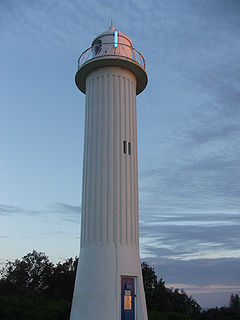
Clarence River Light, also known as Yamba Light or Clarence Head Light, is an active lighthouse located on Pilot Hill, a hill in Wooli Park, Yamba, New South Wales, Australia, south of the entrance of Clarence River. The current lighthouse was built in 1955, replacing a previous lighthouse built in 1880. It serves as the rear range light for two different ranges.
HMAS Waree (W128) was a tug boat operated by the Royal Australian Navy (RAN) during World War II. She operated as a tug boat for the Waratah Tug and Salvage Company before being requisitioned by the RAN in 1942, and operating in northern Australia and Papua. She sank on 17 October 1946 off the New South Wales coast while sailing to Sydney from Thursday Island.
Evans River, an open and trained youthful wave dominated, interbarrier estuary, is located in the Northern Rivers region of New South Wales, Australia.

The Back Creek, a perennial stream of the Richmond River catchment, is located in Northern Rivers region in the state of New South Wales, Australia.
The Tooloom Creek, a perennial stream of the Clarence River catchment, is located in the Northern Rivers region in the state of New South Wales, Australia.
Coordinates: 29°22′41″S153°18′29″E / 29.378°S 153.308°E
| This Northern Rivers geography article is a stub. You can help Wikipedia by expanding it. |