
Wyoming is a state in the Mountain West subregion of the Western United States. It is bordered by Montana to the north and northwest, South Dakota and Nebraska to the east, Idaho to the west, Utah to the southwest, and Colorado to the south. With a population of 576,851 in the 2020 United States census, Wyoming is the least populous state despite being the 10th largest by area, with the second-lowest population density after Alaska. The state capital and most populous city is Cheyenne, which had an estimated population of 63,957 in 2018.

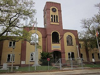
Fremont County is a county in the U.S. state of Wyoming. As of the 2020 United States Census, the population was 39,234, making it the fifth-most populous county in Wyoming. Its county seat is Lander. The county was founded in 1884 and is named for John C. Frémont, a general, explorer, and politician. It is roughly the size of the state of Vermont.

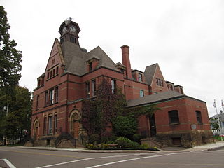
Skamania County is a county located in the U.S. state of Washington. As of the 2020 census, the population was 12,036. The county seat and largest incorporated city is Stevenson, although the Carson River Valley CDP is more populous. The county was founded in 1854 and derives its name from the Cascades Chinook word sk'mániak, meaning "swift waters".

Union County is one of the 36 counties in the U.S. state of Oregon. As of the 2020 census, the population was 26,196. Its county seat is La Grande.

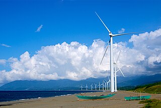
Hood River County is one of the 36 counties in the U.S. state of Oregon. As of the 2020 census, the population was 23,977. The county seat is Hood River. The county was established in 1908 and is named for the Hood River, a tributary of the Columbia River. Hood River County comprises the Hood River, OR Micropolitan Statistical Area. The Hood River Valley is a top producer of apples, pears, and cherries and is known for its famous Fruit Loop driving tour that stops at family farms and fruit stands. Situated between Mount Hood and the Columbia River in the middle of the Columbia River Gorge, Hood River County is a popular destination for outdoor enthusiasts, such as windsurfers, mountain-bikers, skiers, hikers, kayakers, and many more.

Gilliam County is one of the 36 counties in the U.S. state of Oregon. As of the 2020 census, the population was 1,995, making it the third-least populous county in Oregon. The county seat is Condon. The county was established in 1885 and is named for Cornelius Gilliam, a colonel who commanded the forces of the provisional government of Oregon after the Whitman Massacre.
Plaquemines Parish is a parish located in the U.S. state of Louisiana. With a population of 23,515 at the 2020 census, the parish seat is Pointe à la Hache and the largest community is Belle Chasse. The parish was formed in 1807.
Goonengerry is a small village in New South Wales, Australia, 626 km northeast of Sydney. It is known for its horse riding and National Park.

Winder is a city and the county seat of Barrow County, Georgia, United States. It is located east of Atlanta and is part of the Atlanta metropolitan area. The population was 18,338 at the 2020 census.

Wind Gap is a borough in Northampton County, Pennsylvania. The population of Wind Gap was 2,820 at the 2020 census. Wind Gap is part of the Lehigh Valley metropolitan area, which had a population of 861,899 and was the 68th most populous metropolitan area in the U.S. as of the 2020 census.

Floydada is a city in and the county seat of Floyd County, Texas, United States. This rural community lies on the high plains of the Llano Estacado in West Texas and is sometimes referred to as the Pumpkin Capital of Texas. The population was 3,038 at the 2010 census, down from 3,676 at the 2000 census.

Ilocos Norte, is a province of the Philippines located in the Ilocos Region. Its capital is Laoag City, located in the northwest corner of Luzon Island, bordering Cagayan and Apayao to the east, and Abra to the southeast, and Ilocos Sur to the southwest. Ilocos Norte faces the West Philippine Sea to the west and the Luzon Strait to the north.
Summerside is a Canadian city in Prince County, Prince Edward Island. It is the second largest city in the province and the primary service centre for the western part of the island.

North Texas is a term used primarily by residents of Dallas, Fort Worth, and surrounding areas to describe much of the north central portion of the U.S. state of Texas. Residents of the Dallas–Fort Worth metroplex generally consider North Texas to include the area south of Oklahoma, east of Abilene, west of Paris, and north of Waco. A more precise term for this region would be the northern part of the central portion of Texas. It does not include the Panhandle of Texas, which expands further north than the region previously described, nor does it include most of the region near the northern border of Texas.
Bangui, officially the Municipality of Bangui, is a 4th class municipality in the province of Ilocos Norte, Philippines. According to the 2020 census, it has a population of 15,019 people.

Waubra is a town in Victoria, Australia. The town is on the Sunraysia Highway, 33 kilometres (21 mi) north west of Ballarat and split between the Pyrenees Shire and City of Ballarat local government areas. At the 2021 census, Waubra and the surrounding area had a population of 308.
Ramea is a small village in Newfoundland and Labrador located on Northwest Island, one of a group of five major islands located off the south coast of Newfoundland, Canada. The island is approximately 3.14 km long by 0.93 km wide. The other major islands in the archipelago are Great Island, Middle Island, Harbour Island, and South West Island.

Kugaaruk, formerly known as Pelly Bay until 3 December 1999, is located on the shore of Pelly Bay, just off the Gulf of Boothia, Simpson Peninsula, Kitikmeot, in Canada's Nunavut territory. Access is by air by the Kugaaruk Airport and by annual supply sealift. Kugaaruk means "little stream", the traditional name of the brook that flows through the hamlet.

Arriga is a rural locality in the Shire of Mareeba, Queensland, Australia. In the 2016 census, Arriga had a population of 1,079 people.
Boyneside is a rural locality in the South Burnett Region, Queensland, Australia. In the 2016 census, Boyneside had a population of 58 people.
