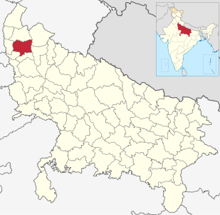
Meerut district, is one of the districts of Uttar Pradesh state of India, and Meerut is the district headquarters. Meerut district is also a part of the Meerut division. The administrative head of district of Meerut is a District Magistrate while the administrative head of Meerut Division is Divisional Commissioner, an IAS officer.

Kemri is a town and a nagar panchayat in Rampur district in the Indian state of Uttar Pradesh.

Bharwari is a small city and Municipal Board in the Kaushambi district located in the state of Uttar Pradesh, India that includes 29 villages in its surrounding area. The city is accessible by the National Highway 2 and by railway linking Bharwari to India's biggest cities. Bharwari railway station is connected to Budh circuit, Mahabodhi Express, which runs from Gaya to New Delhi, and Chauri Chaura Express, which connects Sarnath (Varanasi) to Kaushambi. These trains stop in Bharwari daily. Several other express trains also stop in Bharwari, but not daily.

Pandhurna is a city and a municipality in Chhindwara district in the Indian state of Madhya Pradesh.

Baireddipalle is a village in Palamaner Taluk and Chittoor district of the Indian state of Andhra Pradesh. It is the mandal headquarters of Baireddipalle mandal.
Kakripur is a village in Baghpat district of the Indian state of Uttar Pradesh.

Puritipenta is located in Gajapathinagaram Mandal/Tehsil of Vizianagaram District in Andhra Pradesh State, India.
Pamena is a village and panchayat in Ranga Reddy district, Telangana, India. It falls under Chevella mandal. Pamena a village is on the Chevella-Shadnagar road route. It also a part of Hyderabad Metropolitan Development Authority.

Dhak Pandori is a village in Kapurthala district in North India, in the central part of the Punjab. Dhak Pandori is a small village located in Phagwara Tehsil of Kapurthala district, Punjab with total 441 families residing. The Dhak Pandori village has population of 2439 of which 1297 are males while 1142 are females as per Population Census 2011.

Gundrevula is a large village located in C.Belagal Mandal of Kurnool district, Andhra Pradesh with total 1137 families residing. The Gundrevula village has population of 5014 of which 2561 are males while 2453 are females as per Population Census 2011.
Dighalgram is a village located in Mohammad Bazar Block of Birbhum district, West Bengal with total 1360 families residing. The Dighalgram village has population of 6284 of which 3194 are males while 3090 are females as per Population Census 2011.

Khadaura is a village located near to the deosar town, and 45 km away from the district headquarter.

Dhanghata is a small village located in Bansi Tehsil of Siddharth Nagar district, Uttar Pradesh state of India. It belongs to the Basti division. It is located 40 km west of District headquarters Naugarh and 225 km from State capital Lucknow. It is located on west side of the state highway between Basti and Lumbini.

Annangi is a village located in Maddipadu Mandal of Prakasam district, Andhra Pradesh, India This village in located on the banks of the Gundlakamma river.

Bhonpur is a village that are located near Boinchi in Hooghly district, West Bengal, India. It is under Pandua police station. Approximately it is 3 km apart from this region's main town Boinchi.

Roy-Jamna is a village in Hooghly district, West Bengal, India. The village is 13 meters over sea-level. Its post office is in Roy-Jamna, its police station is in Pandua. Its pincode is 712134 and Bengali is the local language. The village is surrounded by villages named Piragram, Gahami, Baidyapur, etc. This village is about 5 km apart from region's main town Boinchi.
Pratap Pur Chhataura is located in Azamgarh district of Uttar Pradesh. It is 40 km away from District head office. Its pin code is 276142 and its post office is Mangitpur. As per Census 2011 information the village code of Pratap Pur Chhataura village is 192003.
Sahara is a village in Bichpuri Block in Agra District of Uttar Pradesh State, India. It belongs to Agra Division. It is located 13 km towards west from District headquarters Agra. 3 km from Bichpuri. 356 km from State capital Lucknow

Khadotiya is a village in Depalpur tehsil in Indore district of Madhya Pradesh State, India. The village is located 36 km away from district headquarters Indore, 17 km from Depalpur and 212 km from State capital Bhopal.


