
Tuzla is the third-largest city of Bosnia and Herzegovina and the administrative center of Tuzla Canton of the Federation of Bosnia and Herzegovina. As of 2013, it has a population of 110,979 inhabitants.
Cazin is a city located in Una-Sana Canton of the Federation of Bosnia and Herzegovina, an entity of Bosnia and Herzegovina. It is situated in northwest Bosnia and Herzegovina in the Bosanska Krajina region, near the border with Croatia. As of 2013, it has a population of 66,149 inhabitants.

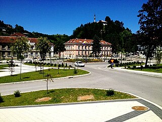
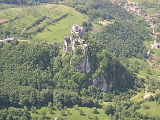
Gradačac is a city located in the Tuzla Canton of the Federation of Bosnia and Herzegovina, an entity of Bosnia and Herzegovina. It is situated in the northeastern part of Bosnia and Herzegovina, roughly 40 km (25 mi) south of the Sava river. As of 2013, it has a population of 39,340 inhabitants. The city is well known for its castle.

Goražde is a city and the administrative center of Bosnian-Podrinje Canton Goražde of the Federation of Bosnia and Herzegovina, an entity of Bosnia and Herzegovina. It is situated on the banks of Drina river. As of 2013, the municipality has a population of 20,897 inhabitants and the city 11,806.

Šamac, formerly Bosanski Šamac is a town and municipality located in the northeastern part of Republika Srpska, an entity of Bosnia and Herzegovina. There are also small, uninhabited, parts located in Odžak municipality and in Domaljevac-Šamac municipality, Federation of Bosnia and Herzegovina.

Zvornik is a city in Bosnia and Herzegovina. It is located in Republika Srpska, on the left bank of the Drina river. In 2013, it had a population of 58,856 inhabitants.

Gračanica is a city located in Tuzla Canton of the Federation of Bosnia and Herzegovina, an entity of Bosnia and Herzegovina. It is located in northeastern Bosnia and Herzegovina, east of Doboj and west of Tuzla. As of 2013, it has a population of 45,220 inhabitants.

Lukavac is a city located in Tuzla Canton of the Federation of Bosnia and Herzegovina, an entity of Bosnia and Herzegovina. According to the 2013 census, the town has a population of 12,061 inhabitants, with 44,520 inhabitants in the city.

Živinice is a city located in Tuzla Canton of the Federation of Bosnia and Herzegovina, an entity of Bosnia and Herzegovina. It is located in northeastern Bosnia and Herzegovina, south of Tuzla. As of 2013, it has a population of 57,765 inhabitants.
Ilijaš is a town and municipality located in Sarajevo Canton of the Federation of Bosnia and Herzegovina, an entity of Bosnia and Herzegovina. It is located northwest of the inner city of Sarajevo and was established in May 1952 with the organization of people's committees. Those local people's committees founded the local municipalities, which led to the self-management of the municipalities, including the municipality of Ilijaš.
Srebrenik is a city located in Tuzla Canton of the Federation of Bosnia and Herzegovina. It is located in northeastern Bosnia and Herzegovina, near Tuzla. As of 2013, it has a population of 39,678 inhabitants. The town of Srebrenik had a population of 6,694.

Vareš (Вареш) is a town and municipality located in Zenica-Doboj Canton of the Federation of Bosnia and Herzegovina, an entity of Bosnia and Herzegovina. It is situated in central Bosnia and Herzegovina, and is famous for the local mining activities and production of iron. As of 2013, it has a population of 8,892 inhabitants, with 2,917 in the town itself.

Ključ is a town and municipality located in the Una-Sana Canton of the Federation of Bosnia and Herzegovina, an entity of Bosnia and Herzegovina. The name of the town and the municipality translates to "Key" in English.

Brod, formerly Bosanski Brod is a town and municipality located in northern Republika Srpska, an entity of Bosnia and Herzegovina. It is situated on the south bank of the river Sava, in the western part of the Posavina region. As of 2013, the town has a population of 7,637 inhabitants, while the municipality has a population of 16,619 inhabitants.
The 1992 Yugoslav People's Army column incident in Tuzla was an attack on the 92nd Motorized Brigade of the Yugoslav People's Army (JNA) in the Bosnian city of Tuzla on 15 May 1992. The incident occurred at the road junction of Brčanska Malta. At least 92 soldiers of the JNA were killed and 33 wounded during the attacks, with estimates reaching 200 killed. What started off as a peaceful retreat by agreement with local authorities but ended in an ambush when Patriotic League, Green Berets and Bosniaks from local police attacked the column. It was a repeat of a similar incident that occurred in Sarajevo a week prior.
Gornja Maoča is a village in northeastern Bosnia that territorially belongs to the Srebrenik municipality, Tuzla Canton in the Federation of Bosnia and Herzegovina. It is in the Majevic mountain range, located directly south from the village of Maoča. The name of the village can be translated as "Upper Maoča".
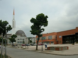
Simin Han is a town east of Tuzla, Bosnia and Herzegovina. It has a school, a mosque, and a youth soccer training centre. Its neighboring towns are Gornja Tuzla and Slavinovići.

Fudbalski klub Tuzla City, formerly known as Fudbalski klub Sloga Simin Han, is a professional football club based in Simin Han, Tuzla, Bosnia and Herzegovina. The club plays in the Premier League of Bosnia and Herzegovina, which is the top tier of football in the country.
The 2018–19 First League of the Federation of Bosnia and Herzegovina was the 24th season of the First League of the Federation of Bosnia and Herzegovina, the second tier league football in Bosnia and Herzegovina, since its original establishment and the 19th as a unified federation-wide league. It began on 11 August 2018 and got concluded on 2 June 2019.
