Related Research Articles

Novi Marof is a town in north-western Croatia, located south of Varaždin and east of Ivanec, in the Varaždin County. It lies on intersection of state roads D3 and D24 and is also connected with highway A4, state road D22 and R201 railway.

Ogulin is a town in north-western Croatia, in Karlovac County. It has a population of 8,216 (2011), and a total municipal population of 13,915 (2011). Ogulin is known for its historic stone castle, known as Kula, and the nearby mountain of Klek.
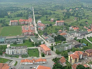
Kalesija is a town and municipality located in Tuzla Canton of the Federation of Bosnia and Herzegovina, an entity of Bosnia and Herzegovina. It is located in northeastern Bosnia and Herzegovina, east of Tuzla. As of 2013, the town has a population of 2,039 inhabitants, and the municipality has 33,053 inhabitants.

Vrapče is a neighborhood of western Zagreb, the capital of Croatia. It is administratively part of the district Podsused—Vrapče. Vrapče consists of Donje Vrapče and Gornje Vrapče. Gornje Vrapče is an eponymous local administrative unit, while the other is called Vrapče - centar.

Krašić is a village and municipality in central Croatia, located near Jastrebarsko and Ozalj, south of Žumberak and north of Kupa, about 50 km southwest of Zagreb. Krašić comprises an area of about 3.63 km2. In the 2011 census, the total population was 2,640, in the following settlements:

Voćin is a village and municipality in western Slavonia, Croatia, located southwest of Slatina and east of Daruvar. The population of the municipality is 2,384, with 1,161 people living in Voćin itself.

Benkovac is a town in the interior of Zadar County, Croatia.
Cestica is a village and municipality in Croatia in the Varaždin County.
Vinica is a village and municipality in Croatia in the Varaždin County.
Brckovljani is a municipality in Zagreb County, Croatia.

Sveti Ivan Zelina is a town in Zagreb County, Croatia.

Jesenje is a municipality in the Krapina-Zagorje County in Croatia. In the 2011 census, there were a total of 1,560 inhabitants. The absolute majority of the population are Croats at 99.36%. The population is distributed in the following settlements:
Oroslavje is a town and municipality in Krapina-Zagorje County in Croatia.

Selnica is a village and municipality in Međimurje County, in northern Croatia.
Majske Poljane is a village in central Croatia, in the municipality/town of Glina, Sisak-Moslavina County. The village's geographic coordinates are 45°21′N16°8′E, the altitude is 162 meters above sea level. The village was severely affected by the 2020 Petrinja earthquake, with five deaths reported.
Gornje Komarevo is a village in Croatia. It is connected by the D224 highway.
Donje Psarjevo is a village in Croatia.
Gornje Podotočje is a village in Croatia.
Donje Ceranje is a village within the town Benkovac. It is 5 km (3.1 mi) south of Benkovac near the Vrana Lake.
Gornje Orešje is a settlement (naselje) in the Sveti Ivan Zelina administrative territory of Zagreb County, Croatia. As of 2011 it had a population of 251 people.
References
- ↑ "Population by Age and Sex, by Settlements, 2011 Census: Gornje Psarjevo". Census of Population, Households and Dwellings 2011. Zagreb: Croatian Bureau of Statistics. December 2012.
Coordinates: 45°57′25″N16°12′17″E / 45.956933°N 16.204618°E
| Authority control |
|
|---|
| | This Zagreb County geography article is a stub. You can help Wikipedia by expanding it. |