
Hotan is a major oasis town in southwestern Xinjiang, an autonomous region in Western China. The city proper of Hotan broke off from the larger Hotan County to become an administrative area in its own right in August 1984. It is the seat of Hotan Prefecture.

Aksu Prefecture is located in mid-Western Xinjiang, People's Republic of China. It has an area of 131,161 km2 (50,642 sq mi) and 2.37 million inhabitants at the 2010 census whom 535,657 lived in the built-up area made up of Aksu urban district. The name Aksu is Turkic for 'white water'. Aksu Prefecture has a 263.8 km (163.9 mi) long international boundary with Kyrgyzstan and Kazakhstan.

Niya County, also from Mandarin Chinese as Minfeng County, is a county within the Xinjiang Uyghur Autonomous Region and is under the administration of the Hotan Prefecture. It contains an area of 56,726 km2 (21,902 sq mi). According to the 2002 census, it has a population of 30,000. The county is bordered to the north by Xayar County, to the east by Qiemo/Qarqan County, to the west by Yutian / Keriya County and to the south by Ngari Prefecture in Tibet.

Qira County, alternatively Chira or Cele, is a county in Hotan Prefecture, Xinjiang Uyghur Autonomous Region, China. Almost all the residents of the county are Uyghurs and live around oases situated between the desolate Taklamakan Desert and Kunlun Mountains. The county is bordered to the north by Aksu Prefecture, to the east by Yutian / Keriya County, to the northwest by Lop County, to the southwest by Hotan County including the China-India disputed Aksai Chin area and to the south by Rutog County, Ngari Prefecture in Tibet.

Lop County, also Luopu, is a county in Hotan Prefecture, in the southwest of the Xinjiang Uyghur Autonomous Region, China. Almost all the residents of the county are Uyghurs and live around oases situated between the desolate Taklamakan Desert and Kunlun Mountains. The county is bordered to the north by Aksu and Awat County in Aksu Prefecture, to the east by Qira/Chira County, to the northwest by Karakax County, to the west by Hotan (Khotan) and to the south and west by Hotan County.

Hotan County is a county in the southwest of the Xinjiang Uyghur Autonomous Region and is under the administration of the Hotan Prefecture. Almost all the residents of the county are Uyghurs and live around oases situated between the desolate Taklamakan Desert and Kunlun Mountains. Hotan County is the southernmost county-level division of Xinjiang. The county borders Karakax/Moyu County to the northwest, Hotan City and Lop County to the northeast, Qira County to the east, Pishan County to the west, and Rutog County, Tibet to the southeast. Hotan County administers most of Aksai Chin, an area disputed between China and India. The Line of Actual Control divides the India-controlled part of Ladakh union territory from the Aksai Chin area administered as part of southwest Hotan County.

Shanshan County as the official romanized name, also transliterated from Uyghur as Piqan County, is a county within the Xinjiang Uyghur Autonomous Region and is under the administrative jurisdiction of the prefecture-level city of Turpan. It contains an area of 39,548 km2 (15,270 sq mi), occupying the eastern majority of Turpan. According to the 2002 census, it has a population of 210,000.

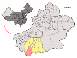
Hotan Prefecture is located in the Dzungaria region in the southwestern part of the Xinjiang Uygur Autonomous Region, China, bordering the Tibet Autonomous Region to the south and Union Territory of Ladakh to the west. The vast majority of the Aksai Chin region which is disputed between China and India is administered as part of Hotan Prefecture. The seat of Hotan Prefecture is Hotan and its largest county by population is Karakax County. The vast majority of the residents of the prefecture are Muslim Uyghurs and live around oases situated between the desolate Taklamakan Desert and Kunlun Mountains.
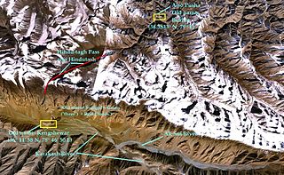
Hindutash, also known as Hindu-tagh Pass, is a historical mountain pass in the western Xinjiang, China. The pass cuts through the Kunlun Mountains connecting the now-deserted town of Kangxiwar in the Karakash River valley to the town of Pusha in the Yurungkash River valley. It also connects to the road to the city of Hotan.
Gumma or Guma may refer to:

Aksai Chin Lake or Aksayqin Lake, is an endorheic lake on the Aksai Chin Plateau. The plateau is administered by China but also claimed by India. The lake is sometimes referred to as Amtogor Lake which is Ladakhi for "encounter with a round object".
The 2011 Hotan attack was a bomb-and-knife attack that occurred in Hotan, Xinjiang, China on July 18, 2011. According to witnesses, the assailants were a group of 18 young Uyghur men who opposed the local government's campaign against the burqa, which had grown popular among older Hotan women in 2009 but were also used in a series of violent crimes. The men occupied a police station on Nuerbage Street at noon, killing two security guards with knives and bombs and taking eight hostages. The attackers then yelled religious slogans, including ones associated with Jihadism, as they replaced the Chinese flag on top of a police station with another flag, the identity of which is disputed.

The Turpan–Hotan Expressway (Chinese: 吐鲁番—和田高速公路, Uyghur: تۇرپان-خوتەن يۇقىرى سۈرئەتلىك تاشيولى ), commonly referred to as the Tuhe Expressway (Chinese: 吐和高速公路), is a Chinese expressway that connects the G30 Lianyungang–Khorgas Expressway at Xiaocaohu, in Toksun County, Turpan, with China National Highway 315 in Lop County, Hotan Prefecture. The expressway, designated G3012, is a spur of the G30 Lianyungang–Khorgas Expressway and is completely in Xinjiang. It is 1,931 kilometres (1,200 mi) in length.
Adil Nurmemet is a former Chinese politician of Uighur ethnicity. He was the Mayor of Hotan, an important city in the Xinjiang interior, between 2009 and 2013. He was investigated by the Communist Party of China's anti-graft agency in October 2014.
Kunyu is a county-level city in Xinjiang Uyghur Autonomous Region, China. It is geographically located in Hotan Prefecture of Southern Xinjiang, but is directly administered by the Xinjiang regional government.