Gotthard Road Tunnel

Last updated

Gotthard Road Tunnel
Gotthard Road Tunnel Switzerland.jpg
The south entrance of Gotthard Road Tunnel
Overview
Location Switzerland
Coordinates 46°40′18″N8°35′33″E / 46.67167°N 8.59250°E / 46.67167; 8.59250
Route A2
Start Göschenen, Uri (north)
End Airolo, Ticino (south)
Operation
Constructed5 May 1970 (1970-05-05)
Opened5 September 1980 (1980-09-05)
Owner Swiss Confederation
OperatorAmt für Betrieb der Nationalstrassen of the cantons of Uri, Ticino, Nidwalden, and Schwyz
TrafficAutomotive
Tollnone (included in the mandatory Vignette)
Vehicles per day17354 (2014) [1]
Technical
Length16.942 kilometres (10.527 mi)
No. of lanes 2
Operating speed80 km/h (50 mph)
Highest elevation1,175 m (3,855 ft)
(inside the tunnel)
Lowest elevation1,080 m (3,540 ft)
(north portal)

The Gotthard Road Tunnel in Switzerland runs from Göschenen in the canton of Uri at its northern portal, to Airolo in Ticino to the south, and is 16.9 kilometres (10.5 mi) in length below the St Gotthard Pass, a major pass of the Alps. At time of construction, in 1980, it was the longest road tunnel in the world; it is currently the fifth-longest. [2] Although it is a motorway tunnel, part of the A2 from Basel to Chiasso, it consists of only one bidirectional tube with two lanes. With a maximum elevation of 1,175 metres (3,855 ft) [3] at the tunnel's highest point, the A2 motorway has the lowest maximum elevation of any direct north-south road through the Alps. [4]

Contents

The tunnel rises from the northern portal at Göschenen (1,080 m (3,540 ft)) and the culminating point is reached after approximately 8 kilometres (5.0 mi). After 10.3 kilometres (6.4 mi) from the northern portal there is the border between the cantons of Uri and Ticino; after another 6.7 kilometres (4.2 mi), the tunnel ends at the southern portal near Airolo (1,146 m (3,760 ft)). The journey takes about 13 minutes by car, the maximum speed being 80 km/h (50 mph).

The Gotthard Road Tunnel is one of the three tunnels that connect the Swiss Plateau to southern Switzerland and run under the Gotthard Massif, the two other being railway tunnels, the Gotthard Tunnel (1882) and the Gotthard Base Tunnel (2016). All three tunnels bypass the Gotthard Pass, an important trade route since the 13th century. The pass road culminates about 1,000 metres (3,300 ft) above the tunnel, at a height of 2,106 metres (6,909 ft), and is only passable in summer.

History

In response to the automobile boom in Switzerland and other things, the Swiss government gave approval in July 1969 for the construction of the 17-kilometre (11 mi) Gotthard Road tunnel. The tunnel would be longer than any existing road tunnel, and would provide a year-round road link from the Swiss Plateau to southern Switzerland, and from northern to southern Europe as well, to be used in place of the Gotthard Pass. [5] The tunnel was built roughly parallel to the old railway tunnel, with portals a few hundred metres away from those of the railway. Prior to the opening of the tunnel, cars were transported through the nearby railway tunnel on car shuttle trains. Following the catastrophic fire in the road tunnel in 2001, car shuttle trains resumed operations for a few weeks.

The tunnel was opened on 5 September 1980. It remains a single bore tunnel with just one lane operating in each direction. It has four large ventilation shafts and an additional side gallery between 10 and 18 metres (33 and 59 ft) from the main tunnel, having its own independent ventilation system in order to facilitate the cutting of a second tunnel, should future traffic levels require it. [5]

On 11 September 2023, the tunnel was temporarily closed after a crack was discovered on the ceiling. [6] The tunnel reopened on 14 September. [7]

2001 collision and fire

On 24 October 2001, a collision of two trucks created a fire in the tunnel, killing eleven and injuring many more, the smoke and gases from the fires being the main cause of death. [8] The tunnel was closed for two months after the accident for repair and cleaning, reopening 21 December 2001. [9] Since the fire, no more than 150 trucks per hour are allowed to enter the tunnel. [8]

Planned second road tunnel

In March 2014, the Swiss Government approved a bill to allow the building of a second road tunnel. Construction was scheduled to start in 2020, with the cost estimated at almost CHF 3 billion. [10] Construction on a second, parallel road tunnel was started. In first instance it was only built for safety: an escape route in case of accidents. This second tunnel is now to be built out to a full road tunnel, potentially allowing four lanes of traffic. Efforts to do this initially failed, blocked by political resistance. The Alpine Initiative "for the protection of the Alpine region from transit traffic", which raised barriers against road tunnel construction, was initially blocked by the Swiss Parliament. A February 1994 Alpine Initiative passed (with 52% of the vote), and Parliament upheld the referendum twice through the 1990s. The pro-tunnel Avanti Initiative brought a referendum to voters in February 2004, which was rejected (by 62.8%). [11]

The Swiss government announced in September 2013 it had approved a plan to upgrade the second tunnel into a full road tunnel in order to allow for the necessary reconstruction of the first road tunnel. Once the works on the first tunnel are finished, the Swiss government plans to operate one single lane in each tunnel (northbound traffic in the newly constructed tunnel, southbound traffic in the renovated one) in order to maintain the current tunnel overall capacity, in compliance with the Swiss constitutional norm that forbids a further growth of the traffic capacity across the Alps. [12]

The reconstruction would have lasted for several years in any variant – one variant would push the traffic over the mountain pass, another proposed to load the vehicles onto trains with a new terminal, a third would close the tunnel for several months every year over time range of a decade. All of these have their drawbacks and the usage of the second tunnel was chosen as the best option to allow for the reconstruction. Further usage of both tunnels was subject to a popular referendum that was held in February 2016, where it was approved. The actual upgrade mining of the second road tunnel was planned to last from 2020 to 2027 at a cost of 2.7 billion francs for the whole project including the following reconstruction of the first tunnel. [13]

Work on an access tunnel started in September 2021, [14] and a major contract for the project was awarded in August 2022. [15] A joint venture between Frutiger, Implenia and Webuild & CSC SA were hired to construct the new tube and a parallel access tunnel. As of 2023, the access tunnel was under construction, while work on the road tunnel was to commence in 2025. [16] The works are scheduled to be completed in 2029. The original tunnel will then close for refurbishment, reopening alongside the new tunnel upon completion of the improvement project in 2032. [17]

Rail tunnels

The 15,003 m (49,222 ft) Gotthard Rail Tunnel, close to but separate from the expressway tunnel, handles rail traffic on the north-south line in Switzerland. It was opened in 1882, at the time the world's longest tunnel, though later superseded by longer tunnels, some over 50 km (31 mi) long.

Under construction since 2002 and opened on 1 June 2016, the Gotthard Base Tunnel (a second rail tunnel, 57 km [35 mi] long), is the world's longest. It was built for the use of trains travelling from northern Switzerland to the Ticino area and beyond. [18]

Road conditions

Inside the Gotthard Road Tunnel Gotthard Road Tunnel Inside.JPG
Inside the Gotthard Road Tunnel

The Gotthard Tunnel is the core and culminating point of the A2 motorway in Switzerland, running south from Basel through the tunnel down to Chiasso on the border with Italy. Traffic flows through only one tunnel, which carries traffic both ways, with each direction allocated one lane. The tunnel's speed limit is 80 km/h (50 mph).

Heavily used, the tunnel often has traffic jams during peak holiday seasons over Easter and summer, on both the north and south ends. In contrast, another tunnel through the Alps, the San Bernardino road tunnel as part of the A13 in the canton of Graubünden further east, is relatively uncongested and shorter.

See also

Related Research Articles

<span class="mw-page-title-main">Transport in Switzerland</span> Overview of transport in Switzerland

Switzerland has a dense network of roads and railways. The Swiss public transport network has a total length of 24,500 kilometres and has more than 2600 stations and stops.

<span class="mw-page-title-main">Lepontine Alps</span> Mountain range in southern Switzerland and northern Italy

The Lepontine Alps are a mountain range in the north-western part of the Alps. They are located in Switzerland and Italy.

<span class="mw-page-title-main">Ticino</span> Canton of Switzerland

Ticino, sometimes Tessin, officially the Republic and Canton of Ticino or less formally the Canton of Ticino, is one of the 26 cantons forming the Swiss Confederation. It is composed of eight districts and its capital city is Bellinzona. It is also traditionally divided into the Sopraceneri and the Sottoceneri, respectively north and south of Monte Ceneri. Red and blue are the colours of its flag.

<span class="mw-page-title-main">Ticino (river)</span> Tributary of the Po river.

The river Ticino is the most important perennial left-bank tributary of the Po. It has given its name to the Swiss canton through which its upper portion flows.

<span class="mw-page-title-main">Rail transport in Switzerland</span> Overview of rail transport in Switzerland

The Swiss rail network is noteworthy for its density, its coordination between services, its integration with other modes of transport, timeliness and a thriving domestic and trans-Alp freight system. This is made necessary by strong regulations on truck transport, and is enabled by properly coordinated intermodal logistics.

<span class="mw-page-title-main">Gotthard Base Tunnel</span> Railway tunnel through the Swiss Alps

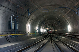
The Gotthard Base Tunnel is a railway tunnel through the Alps in Switzerland. It opened in June 2016 and full service began the following December. With a route length of 57.09 km (35.5 mi), it is the world's longest railway and deepest traffic tunnel and the first flat, low-level route through the Alps. It lies at the heart of the Gotthard axis and constitutes the third tunnel connecting the cantons of Uri and Ticino, after the Gotthard Tunnel and the Gotthard Road Tunnel.

<span class="mw-page-title-main">Airolo</span> Municipality in Ticino, Switzerland

Airolo is a municipality in the district of Leventina in the canton of Ticino in Switzerland.

<span class="mw-page-title-main">A13 motorway (Switzerland)</span> Motorway in Switzerland

The A13 is a motorway, at times an Autostrasse (expressway), which runs from St. Margrethen in northeastern Switzerland through to Ascona in southern Switzerland, crossing the main chain of the Alps in the Grisons area. It is the southern half of European route E43.

<span class="mw-page-title-main">San Bernardino Tunnel</span> Tunnel in Switzerland

The San Bernardino road tunnel is a road tunnel in the canton of Graubünden in south-eastern Switzerland. It runs under the San Bernardino Pass between the town of San Bernardino and the town of Hinterrhein, and forms part of the A13 motorway and the European route E43. The tunnel was completed in 1967 and is 6,596 metres (21,640 ft) long. Since the opening of the tunnel, the Val Mesolcina, one of the Italian-speaking southern valleys of Graubünden, is now connected all-year round with the rest of the canton.

<span class="mw-page-title-main">A2 motorway (Switzerland)</span>

The A2 is a motorway in Switzerland. It forms Switzerland's main north–south axis from Basel to Chiasso, meandering with a slight drift toward the east. It lies on the Gotthard axis and crosses the Alps. Opened in 1955 under the name "Road Lucerne-south", A2 is one of the busiest motorways in Switzerland.

<span class="mw-page-title-main">NRLA</span> Swiss rail project

The New Railway Link through the Alps, is a Swiss construction project for faster north–south rail links across the Swiss Alps. It consists of two axes with several improvements along these rails including three new base tunnels several hundred metres below the existing apex tunnels, the 57-kilometre (35 mi) Gotthard Base Tunnel, the 35-kilometre (22 mi) Lötschberg Base Tunnel, and the 15-kilometre (9.3 mi) Ceneri Base Tunnel. Swiss Federal Railways subsidiary AlpTransit Gotthard AG and BLS AG subsidiary BLS Alp Transit AG were founded for this project and built the tunnels.

<span class="mw-page-title-main">Gotthard Pass</span> Mountain pass through the Swiss Alps

The Gotthard Pass or St. Gotthard Pass at 2,106 m (6,909 ft) is a mountain pass in the Alps traversing the Saint-Gotthard Massif and connecting northern Switzerland with southern Switzerland. The pass lies between Airolo in the Italian-speaking canton of Ticino, and Andermatt in the German-speaking canton of Uri, and connects further Bellinzona and Lugano to Lucerne, Basel, and Zurich. The Gotthard Pass lies at the heart of the Gotthard, a major transport axis of Europe, and it is crossed by three traffic tunnels, each being the world's longest at the time of their construction: the Gotthard Rail Tunnel (1882), the Gotthard Road Tunnel (1980) and the Gotthard Base Tunnel (2016). With the Lötschberg to the west, the Gotthard is one of the two main north-south routes through the Swiss Alps.

<span class="mw-page-title-main">Andermatt</span> Municipality in Uri, Switzerland

Andermatt is a mountain village and municipality in the canton of Uri in Switzerland. At an elevation of 1,437 meters (4,715 ft) above sea level, Andermatt is located at the center of the Saint-Gotthard Massif and the historical center cross of north-south and east-west traverses of Switzerland. It is some 28 km (17 mi) south of Altdorf, the capital of Uri.

<span class="mw-page-title-main">Schöllenen Gorge</span>

Schöllenen Gorge is a gorge formed by the upper Reuss in the Swiss canton of Uri between the towns of Göschenen to the north and Andermatt to the south. It provides access to the St Gotthard Pass.

<span class="mw-page-title-main">Gotthard Tunnel</span> Railway tunnel in Switzerland

The Gotthard Tunnel is a 15-kilometre-long (9.3 mi) railway tunnel that forms the summit of the Gotthard Railway in Switzerland. It connects Göschenen with Airolo and was the first tunnel through the Saint-Gotthard Massif in order to bypass the St Gotthard Pass. It was built as single bore tunnel accommodating a standard gauge double-track railway throughout. When opened in 1882, the Gotthard Tunnel was the longest tunnel in the world.
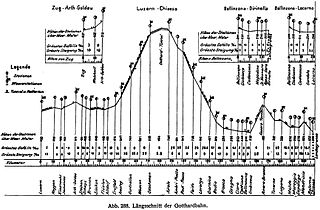
<span class="mw-page-title-main">Gotthard railway</span> Key central Swiss transport link

The Gotthard railway is the Swiss trans-alpine railway line from northern Switzerland to the canton of Ticino. The line forms a major part of an important international railway link between northern and southern Europe, especially on the Rotterdam-Basel-Genoa corridor. The Gotthard Railway Company was the former private railway company that financed the construction of and originally operated that line.

<span class="mw-page-title-main">Ceneri Base Tunnel</span> Railway tunnel through the Swiss Alps

The Ceneri Base Tunnel is a Swiss railway base tunnel in the canton of Ticino. It passes under Monte Ceneri between Camorino in the Magadino Flat and Vezia near Lugano; it bypasses the former high-altitude rail route through the Monte Ceneri Tunnel. It is composed of two single-track tunnels, each 15.4 km (9.6 mi) long. It is part of the New Railway Link through the Alps (NRLA) project for faster north-south rail links across the Swiss Alps.

<span class="mw-page-title-main">Göschenen railway station</span> Railway station in Göschenen, Switzerland

Göschenen railway station is a railway station in the Swiss canton of Uri and municipality of Göschenen. Situated on the original line of the Gotthard railway, at the northern mouth of the Gotthard Tunnel, the station is also the junction point with the Schöllenenbahn. Most trains on the Gotthard route now use the Gotthard Base Tunnel and do not pass through Göschenen station.

<span class="mw-page-title-main">National Redoubt (Switzerland)</span> Defensive plan developed by the Swiss government

The Swiss National Redoubt is a defensive plan developed by the Swiss government beginning in the 1880s to respond to foreign invasion. In the opening years of the Second World War the plan was expanded and refined to deal with a potential German invasion. The term "National Redoubt" primarily refers to the fortifications begun in the 1880s that secured the mountainous central part of Switzerland, providing a defended refuge for a retreating Swiss Army.

<span class="mw-page-title-main">Airolo railway station</span>

Airolo railway station is a railway station in the Swiss canton of Ticino and municipality of Airolo. The station is on the original line of the Swiss Federal Railways Gotthard railway, at the southern entrance to the Gotthard Tunnel. Most trains on the Gotthard route now use the Gotthard Base Tunnel and do not pass through Airolo station.

References

  1. "Verkehrsentwicklung am Gotthard-Strassentunnel" (in German, French, and Italian). ASTRA – Swiss Federal Roads Office. 2015. Archived from the original on 17 April 2016. Retrieved 7 June 2016.
  2. After Norway's Lærdal Tunnel (24.5 km (15.2 mi)), Australia's WestConnex (21.8 km (13.5 mi)), Japan's Yamate Tunnel (18.2 km (11.3 mi)), and China's Zhongnanshan Tunnel 18 km (11 mi).
  3. Der Tiefbau, Volume 14 (1974)
  4. The other direct north-south roads through the Alps with similar elevations are: Fréjus Road Tunnel (>1,297 m), Mont Blanc Tunnel (1,395 m) and Brenner Pass (1,370 m)
  5. 1 2 "News and Views: Gotthard Road Tunnel". Autocar . Vol. 131, no. 3843. 31 July 1969. p. 29.
  6. Baschuk, Bryce (11 September 2023). "Switzerland Closes Gotthard Road Tunnel in Latest Snarl-Up". Bloomberg.com. Retrieved 28 September 2023.
  7. "Switzerland's closed Gotthard road tunnel now open". Le News. 14 September 2023. Retrieved 28 September 2023.
  8. 1 2 "Gotthard-Strassentunnel ist sicherer geworden – SWI". Swissinfo.ch (in German). Retrieved 25 January 2016.
  9. "chronik". Gotthardtunnel.ch. Archived from the original on 12 June 2016. Retrieved 25 January 2016.
  10. Geiser, Urs (24 September 2014). "Second Gotthard road tunnel given green light". Swissinfo.ch. Retrieved 25 January 2016.
  11. Alpine-initiative.ch Archived 28 September 2007 at the Wayback Machine , History, accessed 5 September 2007.
  12. "Gotthard II: an extra tunnel but no new traffic". DriveEuropeNews.com. 16 September 2013. Retrieved 25 January 2016.
  13. "Bundesrat will zweite Röhre für Gotthard-Strassentunnel". SF Schweizer Fernsehen. 27 June 2012. Retrieved 27 June 2012.
  14. "Work started this week on second Gotthard road tunnel". Le News. 30 September 2021. Retrieved 28 September 2023.
  15. Smith, Claire (22 August 2022). "Major contract awarded for construction on the second Gotthard road tunnel". New Civil Engineer. Retrieved 28 September 2023.
  16. "First breakthrough on Second Gotthard Tunnel". Tunnels & Tunnelling International. 9 May 2023. Retrieved 28 September 2023.
  17. "Ceremony marks start of second Gotthard tunnel construction". swissinfo.ch. 29 September 2021. Retrieved 17 May 2023.
  18. Bilger, Burkhard (15 September 2008). "The Long Dig: Getting through the Swiss Alps the hard way". The New Yorker .
Records
Preceded by
Arlberg Road Tunnel
13.98 km (8.69 mi)
World's longest road tunnel
1980–2000
Succeeded by
Lærdal Tunnel
24.51 km (15.23 mi)