Gough Map

Last updated

The Gough Map. North lies to the left of the map. Gough Kaart (hoge resolutie).jpg
The Gough Map. North lies to the left of the map.
Facsimile of the Gough Map by the Ordnance Survey. First published in 1870, the red transcriptions of ancient names were added in the 1935 edition Ordnance Survey reproduction Bodleian map Britain 1325-1350.jpg
Facsimile of the Gough Map by the Ordnance Survey. First published in 1870, the red transcriptions of ancient names were added in the 1935 edition

The Gough Map or Bodleian Map [1] is a Late Medieval map of the island of Great Britain. Its precise dates of production and authorship are unknown. It is named after Richard Gough, who bequeathed the map to the Bodleian Library in 1809. He acquired the map from the estate of the antiquarian Thomas "Honest Tom" Martin in 1774. [2] Numerous copies of it have been made, with an interactive online version created at Queen's University, Belfast. [3] It measures 115 by 56 cm. [4]

Contents

Date

There has been no authoritative date for the map's production. Thomas Martin believed it dated from the reign of Edward III, [5] while 19th-century scholarship suggested a date of c. 1300, during the reign of Edward I. More recently, the map was believed to have been made within an eleven-year window, based on historical changes of place names and sizes. [6] The earliest given date is deduced by the depiction of a city wall around Coventry, which was first constructed in 1355. The latter date is usually given as 1366, the year in which the town marked on the map as Sheppey was renamed Queenborough.

Most recent studies, based on handwriting and stylistic evidence, support a later period of production. One study concludes that the map must have been made in the early years of the fifteenth century, [7] while another suggests that the map was produced in the 1370s but extensively revised, perhaps as late as 1430. [8]

It is generally accepted that the map may have been conceived earlier, and that it could have been one of several similar copies. In particular, it has been argued that some of the information on the map reflects the interests of Edward I, dating the prototype to around 1280. [9]

Authorship

The map's authorship is also unknown. It is thought that much of the information about the map was gained from either one or more men who travelled around Great Britain as part of Edward I's military expeditions into Wales and Scotland. The areas of the map's fringe with the most accurate detail often correspond with those areas in which Edward's troops were present. [6] The accuracy of the map in the South Yorkshire and Lincolnshire areas suggest that the author could be from this region. [10] However, it is also possible that the map was constructed based upon the collation of various people's local knowledge. For example, the cartographic accuracy in Oxfordshire could be explained by the fact that William Rede, Fellow of Merton College, had successfully calculated the geographic coordinates for Oxford in 1340. [11]

Topography and accuracy

15th C. map of the British Isles based on Ptolemy's 2nd C. map Descriptio Prime Tabulae Europae.jpg
15th C. map of the British Isles based on Ptolemy's 2nd C. map

The Gough Map is important due to its break with previous theologically based mapping. [12] Apart from the Tabula Peutingeriana, its depiction of routes and marked distances is unique in British maps before the 17th century. And compared to previously known maps, like Ptolemy's Geography, it greatly improves the detail on the coast of England and Wales, although its depiction of the then independent Kingdom of Scotland is very poor. [11] Towns are shown in some detail, with London and York written in gold lettering and other principal settlements illustrated in detail. [1] Despite its accuracy, the map does contain a number of other errors. Notably, islands and lakes such as Anglesey and Windermere are oversized, whilst the strategic importance of rivers is shown by their emphasis. Well known but geographically small features such as the Peninsula in Durham are also overly-prominent. [11] The map contains numerous references to mythology as if they were geographical fact, as illustrated by comments about Brutus' mythical landings in Devon. [11] Nevertheless, it remains the most accurate map of Britain prior to the 16th century. [6]

The red lines

A notable feature of the Gough Map is the disjointed network, across much of England and Wales, of narrow red lines drawn between settlements. With few exceptions, each is marked with a distance (of an unknown unit [13] ) in Roman numerals. Richard Gough described these lines as 'roads', and that description held throughout the 19th and 20th centuries. Indeed, the document is still often referred to as a 'road map of Britain'. [14] In a change of emphasis, however, recent scholarship sees the lines as routes, or as graphic representations of distance rather than of physical roads. [15]

Scholars have struggled to explain the idiosyncratic inclusions and omissions. For example, there are no routes from London towards the south or east, and large sections of Watling Street are omitted. [6] It has been speculated that the selection of routes might reflect the movements or interests of the map's owner, [16] or that the compiler chose to show only the routes for which he had recorded distances, from existing itineraries. [17] In any case, as the route network neither covers the whole of the map nor shows all the principal routes, it could not have served as a wayfinding aid in the sense that the term 'road map' implies. [18] The lines are generally considered to be a secondary feature – even an afterthought [19] – on a map principally of settlements. [20]

Recent research

In 2012 an interdisciplinary team convened to take a new look at the Gough map. Their task was to re-evaluate the existing, often contradictory, literatures with the aid of newly-available high resolution scans and spectral imaging techniques. The team reported its findings at a work-in-progress Symposium in 2015 at the Bodleian Library, [21] and a summary of provisional findings was published in 2017. [22] These qualify much that has hitherto been believed about the map. Most significantly, it is proposed that the extant cartographical image is not a single map, but an accumulation of three distinct layers: Layer One (1390-1410) showing the whole of Britain; Layer Two (first quarter 15th century) comprising England south of the Wall and Wales; Layer Three (last quarter 15th century) restricted to south-east and south-central England. The last two layers in particular are individualised by systematic re-inkings, [23] additions of colour and other details and alterations to place-names.

A study of the pinholes was undertaken. The holes occur in groups, marking the shapes of many of the pictorial town signs across the map – though the holes are absent from Kent, East Anglia, and the southwest. Some of the pricked outlines have no corresponding ink line, and in some places the group of holes is offset from the inked sign. This has led to the conclusion that the holes are most likely medieval in origin, and were made while copying onto the map during its first production, rather than while copying from it. Hitherto they were thought to have been part of the copying process for the creation of the facsimile for Gough's British Topography. [24]

Traditional conclusions about other aspects of the map were revised, including many transcriptions of place-names and the identification of some places represented on the map. New discoveries have also been made about the subsequent history of the map. Grey stains over many of the place names have been found to be caused by a reagent (made from oak galls and Madeira wine) applied at Richard Gough's request, that he had hoped would make faded writing more legible. On-going research extends the number of regional case studies already carried out (Northwest England, North Norfolk coast).

The Gough Map in culture

A BBC television series In Search of Medieval Britain (2008) showed Alixe Bovey retracing a series of journeys through Britain in the Middle Ages using the Gough Map. [25] [26]

In May 2011, the Gough Map was inscribed in UNESCO's UK Memory of the World Register. [27] [28] [29]

Online digitization

From April 2010 to July 2011 a research project funded by the UK AHRC Research Council's Beyond Text programme digitised and created a new online edition of the Gough Map. The edition was a collaboration between Keith Lilley at Queen's University Belfast, Nick Millea at the University of Oxford's Bodleian Library Map Room, and Paul Vetch at the Department of Digital Humanities at King's College London.

Notes

  1. 1 2 "The Gough Map". Bodleian Library. 2005. Archived from the original on 10 May 2008. Retrieved 1 February 2008.
  2. Gough, Richard (1780). British Topography. Or, an Historical Account of What has been Done for Illustrating the Topographical Antiquities of Great Britain and Ireland. London: T. Payne and Son, and J. Nichols. p.  76 . Retrieved 25 March 2016.
  3. "Mapping the Realm". Queen's University, Belfast. 2006. Archived from the original on 19 May 2019. Retrieved 1 February 2008.
  4. Gough Map - About
  5. Gough, Richard (1780). British Topography. Or, an Historical Account of What has been Done for Illustrating the Topographical Antiquities of Great Britain and Ireland. London: T. Payne and Son, and J. Nichols. p.  76.
  6. 1 2 3 4 Pelham, R.A. (January 1933). "The Gough Map". The Geographical Journal . 81 (1): 34–39. doi:10.2307/1783891. JSTOR   1783891.
  7. Smallwood, T. M. (2009). "The Date of the Gough Map". Imago Mundi. 62 (1): 23. doi: 10.1080/03085690903407997 .
  8. Solopova, Elizabeth (2012). "The Making and Re-making of the Gough Map of Britain: Manuscript Evidence and Historical Context". Imago Mundi. 64 (2): 160. doi:10.1080/03085694.2012.673758.
  9. Millea, Nick (2007). The Gough Map: The Earliest Road Map of Great Britain?. Oxford: Bodleian Library. p. 13. ISBN   9781851240227.
  10. Tom Phillips (2008). "Earliest British map is cock of the north". Metro.co.uk. Retrieved 1 February 2008.
  11. 1 2 3 4 "Britain's first road map". Oxford Today. 2006. Archived from the original on 17 April 2008. Retrieved 1 February 2008.
  12. Millea, Nick (2007). The Gough Map: The earliest Road Map of Great Britain?. Oxford: Bodleian Library. p. 19. ISBN   9781851240227.
  13. "[...]somewhere between ten and eleven furlongs. One possibility is that it is the old French mile [...]"Millea, Nick (2007). The Gough Map: The earliest Road Map of Great Britain?. Oxford: Bodleian Library. p. 32. ISBN   9781851240227.
  14. For example, by the Bodleian Library shop: http://www.bodleianshop.co.uk/gough-map-facsimile.html
  15. Kain, Delano-Smith pg 143; Millea pg 32, Smallwood[1] pg 3; Solopova pg 163 [full refs to add]
  16. Edward I, for example (as a potential owner of the prototype). Daniel Birkholz, The King’s Two Maps: Cartography and Culture in Thirteenth-Century England (Routledge, 2004)
  17. F. M. Stenton, The Road System of Medieval England, The Economic History Review Vol. 7, No. 1 (November 1936), pp. 1-21 DOI: 10.2307/2590730 [full link to add]
  18. Delano-Smith argues that the road atlas and road map were "the one purpose for which maps were not used in pre-modern times".[full ref to add]
  19. Parsons; Lilley pg 17; Solopova pg 163 [full refs to add]
  20. Lilley and Lloyd pg 2; Lilley, Mapping Plantagenet Rule Through the Gough Map of Great Britain pg 96 [full refs to add]
  21. "What's On? | Gough Map Symposium 2015: Mr Gough's 'curious map' of Britain: old image, new techniques". www.bodleian.ox.ac.uk. Retrieved 24 January 2017.
  22. Delano Smith, C. (2017). "New Light on the Medieval Gough Map of Britain". Imago Mundi. 69 (1): 1. doi:10.1080/03085694.2017.1242838.
  23. Solopova, Elizabeth (2012). "The Making and Re-making of the Gough Map of Britain: Manuscript Evidence and Historical Context". Imago Mundi. 64 (2): 160. doi:10.1080/03085694.2012.673758.
  24. Parsons, E.J.S. (1958). The Map of Great Britain, circa 1360, known as The Gough Map (1 ed.). University Press, Oxford. p. 4. The outlines of the symbols have been pricked through, a fact that was noted by W.B.Sanders in 1875. Since there is no mention of the pricking by Gough, it is probable that it was done by Basire when preparing his reproduction for Gough's British Topography.
  25. BBC In Search of Medieval Britain Retrieved 2010-10-06
  26. Bodleian Library, Oxford University, Gough Map plays its part in search for Medieval Britain Retrieved 2010-10-06
  27. "2011 UK Memory of the World Register", United Kingdom National Commission for UNESCO, 2011. Accessed 4 June 2011.
  28. "Gough Map added to UNESCO’s UK Memory of the World Register Archived 2011-07-01 at the Wayback Machine ", Linguistic Geographies: The Gough Map of Great Britain, 23 May 2011. Accessed 4 June 2011.
  29. "Bodleian items added to UNESCO's UK Memory of the World Register", Bodleian Libraries, 23 May 2011. Accessed 4 June 2011.

Related Research Articles

<span class="mw-page-title-main">Cartography</span> Study and practice of making maps

Cartography is the study and practice of making and using maps. Combining science, aesthetics and technique, cartography builds on the premise that reality can be modeled in ways that communicate spatial information effectively.

Richard Gough was a prominent and influential English antiquarian. He served as director of the Society of Antiquaries of London from 1771 to 1791; published a major work on English church monuments; and translated and edited a new edition of William Camden's Britannia.

<span class="mw-page-title-main">History of geography</span> Aspect of history

The history of geography includes many histories of geography which have differed over time and between different cultural and political groups. In more recent developments, geography has become a distinct academic discipline. 'Geography' derives from the Greek γεωγραφία – geographia, literally "Earth-writing", that is, description or writing about the Earth. The first person to use the word geography was Eratosthenes. However, there is evidence for recognizable practices of geography, such as cartography (map-making), prior to the use of the term.

<span class="mw-page-title-main">Hereford Mappa Mundi</span> Map of the known world dating from c.1300

The Hereford Mappa Mundi is a medieval map of the known world, of a form deriving from the T and O pattern, dating from c. 1300. Archeological scholars believe the map to have originated from eastern England in either Yorkshire or Lincolnshire before it was transported westward to the Hereford Cathedral in Herefordshire where it has remained ever since. It is displayed at Hereford Cathedral in Hereford, England. It is the largest medieval map still known to exist. A larger mappa mundi, the Ebstorf map, was destroyed by Allied bombing in 1943, though photographs of it survive.

<span class="mw-page-title-main">John Rocque</span> Surveyor and cartographer (c. 1704–1762)

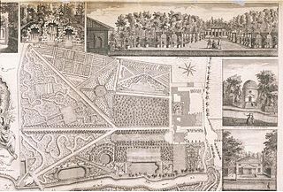
John Rocque was a French-born British surveyor and cartographer, best known for his detailed map of London published in 1746.

The OS MasterMap is the premier digital product of the Ordnance Survey. It was launched in November 2001. It is a database that records every fixed feature of Great Britain larger than a few meters in one continuous digital map. Every feature is given a unique TOID, a simple identifier that includes no semantic information. Typically each TOID is associated with a polygon that represents the area on the ground that the feature covers, in National Grid coordinates. OS MasterMap is offered in themed "layers", for example a road layer and a building layer, each linked to a number of TOIDs. Pricing of licenses for OS MasterMap data depends on: the total area requested, the layers licensed, the number of TOIDs in the layers, the period in years of the data usage.

The earliest known world maps date to classical antiquity, the oldest examples of the 6th to 5th centuries BCE still based on the flat Earth paradigm. World maps assuming a spherical Earth first appear in the Hellenistic period. The developments of Greek geography during this time, notably by Eratosthenes and Posidonius culminated in the Roman era, with Ptolemy's world map, which would remain authoritative throughout the Middle Ages. Since Ptolemy, knowledge of the approximate size of the Earth allowed cartographers to estimate the extent of their geographical knowledge, and to indicate parts of the planet known to exist but not yet explored as terra incognita.

<i>Book of Roads and Kingdoms</i> Genre of Islamic manuscripts

The Book of Roads and Kingdoms is a group of Islamic manuscripts composed from the Middle Ages to the early modern period. They emerged from the administrative tradition of listing pilgrim and post stages. Their text covers the cities, roads, topography, and peoples of the Muslim world, interspersed with personal anecdotes. A theoretical explanation of the "Inhabited Quarter" of the world, comparable to the ecumene, frames the world with classical concepts like the seven climes.

<span class="mw-page-title-main">Majorcan cartographic school</span> Medieval naval group

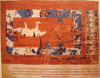
"Majorcan cartographic school" is the term coined by historians to refer to the collection of predominantly Jewish cartographers, cosmographers and navigational instrument-makers and some Christian associates that flourished in Majorca in the 13th, 14th and 15th centuries until the expulsion of the Jews. The label is usually inclusive of those who worked in Catalonia. The Majorcan school is frequently contrasted with the contemporary Italian cartography school.

<span class="mw-page-title-main">Selden Map</span>

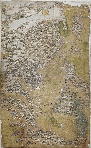
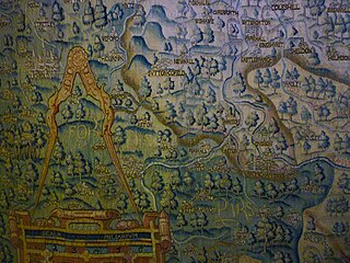
The Selden Map of China is an early 17th century map of East Asia formerly owned by the legal scholar and maritime theorist John Selden. It shows a system of navigational routes emanating from a point near the cities of Quanzhou and Zhangzhou in Fujian Province, from which a principal route goes northeast towards Nagasaki and southwest towards Hoi An, then Champa, and then on to Pahang, and then with another route heading past Penghu towards a point northwest by Manila.

<span class="mw-page-title-main">Sheldon tapestries</span>

Sheldon tapestries were produced at Britain's first large tapestry works in Barcheston, Warwickshire, England, established by the Sheldon family. A group of 121 tapestries dateable to the late 16th century were produced. Much the most famous are four tapestry maps illustrating the counties of Gloucestershire, Worcestershire, Oxfordshire and Warwickshire, with most other tapestries being small furnishing items, such as cushion covers. The tapestries are included in three major collections: the Victoria and Albert Museum, London; the Metropolitan Museum of Art, New York; and the Burrell Collection, Glasgow, Scotland. Pieces were first attributed in the 1920s to looms at Barcheston, Warwickshire by a Worcestershire antiquary, John Humphreys, without clear criteria; on a different, but still uncertain basis, others were so classified a few years later. No documentary evidence was then, or is now, associated with any tapestry, so no origin for any piece is definitely established.

<span class="mw-page-title-main">Island of the Jewel</span> Semi-legendary island in medieval Arabic cartography

The Island of the Jewel or Island of Sapphires was a semi-legendary island in medieval Arabic cartography, said to lie in the Sea of Darkness near the equator, forming the eastern limit of the inhabited world. The island does not appear in any surviving manuscript of Ptolemy's Geography nor other Greek geographers. Instead, it is first attested in the Ptolemaic-influenced Book of the Description of the Earth compiled by al-Khwārizmī around 833. Ptolemy's map ended at 180° E. of the Fortunate Isles without being able to explain what might lay on the imagined eastern shore of the Indian Ocean or beyond the lands of Sinae and Serica in Asia. Roman missions subsequently reached the Han court via Longbian (Hanoi) and Chinese Muslims traditionally credit the founding of their community to the Companion Saʿd ibn Abi Waqqas as early as the 7th century. Muslim merchants such as Soleiman established sizable expatriate communities; a large-scale massacre of Arabs and Persians is recorded at Yangzhou in 760. These connections showed al-Khwārizmī and other Islamic geographers that the Indian Ocean was not closed as Hipparchus and Ptolemy had held but opened either narrowly or broadly.

<i>De laude Cestrie</i>

De laude Cestrie, also known as Liber Luciani de laude Cestrie, is a medieval English manuscript in Latin by Lucian of Chester, probably a monk at the Benedictine Abbey of St Werburgh in Chester. Believed to date from the end of the 12th century, it has been described as "the oldest extant piece of Cheshire writing," and, with its first-hand description of the medieval town of Chester, is one of the earliest examples of prose writing about an English urban centre. It is also notable for the earliest extended description of Chester's county palatine status, which Lucian writes "gives heed ... more to the sword of its prince than to the crown of the king." The original manuscript is held by the Bodleian Library, Oxford. Excerpts have been published in 1600, 1912 and 2008.

Elizabeth Solopova is a Russian-British philologist and medievalist undertaking research at New College, Oxford. She is known outside academic circles for her work on J. R. R. Tolkien's Middle-earth writings.

<span class="mw-page-title-main">Jerry Brotton</span> British historian

Jeremy Brotton is a British historian. He is Professor of Renaissance Studies at Queen Mary University of London, a television and radio presenter and a curator.

The cartography of the region of Palestine, also known as cartography of the Holy Land and cartography of the Land of Israel, is the creation, editing, processing and printing of maps of the region of Palestine from ancient times until the rise of modern surveying techniques. For several centuries during the Middle Ages it was the most prominent subject in all of cartography, and it has been described as an "obsessive subject of map art".

Emilie Savage-Smith is an American-British historian of science known for her work on science in the medieval Islamic world and medicine in the medieval Islamic world.

<i>Book of Curiosities</i> Arabic book

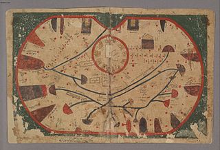
The Book of Curiosities is an anonymous 11th-century Arabic cosmography from Fatimid Egypt containing a series of early illustrated maps of the world and celestial diagrams of the universe and sky. TheBook of Curiosities contains 17 maps in total, 14 of which are extremely rare not only in Islamic cartography but also in greater medieval map history. The cosmography includes the earliest recorded map of Sicily as well as a rectangular world map, considered the earliest surviving map with a graphic scale. The autograph manuscript has not survived, but the Bodleian Library of Oxford University acquired one of the only known copies of the manuscript in 2002, making its contents widely accessible today due to its digitization. Based on the production processes and physical materials of the copy, such as paper and pigment, scholars date the production of this copy to the early 13th century.

Evelyn Edson is an author, medievalist, and professor emerita of history. She is known for her three books on the history of cartography.

Keith Lilley is Professor at Queen's University Belfast, known as a historical geographer and urban historian.

References