ISO 8601Data elements and interchange formats – Information interchange – Representation of dates and times is an international standard covering the exchange of date- and time-related data. It is maintained by the Geneva-based International Organization for Standardization (ISO) and was first published in 1988 with updates in 1991, 2000, 2004 and 2019. The purpose of this standard is to provide an unambiguous and well-defined method of representing dates and times, so as to avoid misinterpretation of numeric representations of dates and times, particularly when data is transferred between countries with different conventions for writing numeric dates and times.

Petersburg Borough is a borough in the U.S. state of Alaska. According to Census Bureau estimates, the population was 3,266 in 2019. The borough seat is Petersburg. Petersburg is the most recently created county equivalent in the United States.

Gourcy is a town in the Gourcy Department in the province of Zondoma in Burkina Faso. It is the capital of Zondoma Province.
St. Mary's Alpine Provincial Park is a provincial park in British Columbia, Canada. According to the Canadian Ministry of the Environment:
St. Mary’s Alpine Park is a wilderness paradise for the experienced backcountry traveller. Numerous lakes and tarns are tucked against rugged granite cliffs and surrounded by tundra and lingering snowfields. Seven creeks drain the lakes, resulting in numerous waterfalls and cataracts, some as much as 150 metres in height. Experienced hikers, willing to expend considerable effort in bushwhacking and route finding should visit this protected area where few, if any, people will be encountered.
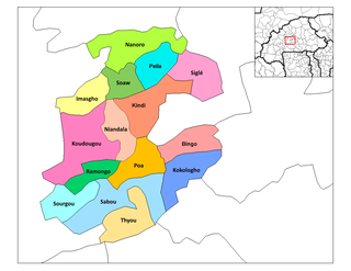
Nandiala is a department or commune of Boulkiemdé Province in central Burkina Faso. As of 2005 it has a population of 33,530. Its capital lies at the town of Nandiala.

Kramkowo is a village in the administrative district of Gmina Wizna, within Łomża County, Podlaskie Voivodeship, in north-eastern Poland. It lies approximately 3 kilometres (2 mi) west of Wizna, 19 km (12 mi) east of Łomża, and 56 km (35 mi) west of the regional capital Białystok.
Przezwody is a village in the administrative district of Gmina Proszowice, within Proszowice County, Lesser Poland Voivodeship, in southern Poland. It lies approximately 4 kilometres (2 mi) east of Proszowice and 34 km (21 mi) north-east of the regional capital Kraków.
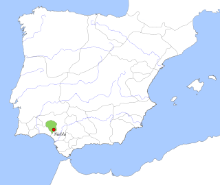
The Taifa of Niebla was an Arab taifa kingdom that existed during three distinct time periods: from 1023 to 1053, from 1145 to 1150 and from 1234 to 1262.

Golice is a village in the administrative district of Gmina Siedlce, within Siedlce County, Masovian Voivodeship, in east-central Poland. It lies approximately 7 kilometres (4 mi) north-east of Siedlce and 93 km (58 mi) east of Warsaw.
Kamion is a village in the administrative district of Gmina Młodzieszyn, within Sochaczew County, Masovian Voivodeship, in east-central Poland. It lies approximately 6 kilometres (4 mi) north of Młodzieszyn, 14 km (9 mi) north of Sochaczew, and 57 km (35 mi) west of Warsaw.
Kudelczyn is a village in the administrative district of Gmina Bielany, within Sokołów County, Masovian Voivodeship, in east-central Poland. It lies approximately 4 kilometres (2 mi) west of Bielany, 8 km (5 mi) south-west of Sokołów Podlaski, and 84 km (52 mi) east of Warsaw.
Obrona is a village in the administrative district of Gmina Kleczew, within Konin County, Greater Poland Voivodeship, in west-central Poland. It lies approximately 3 kilometres (2 mi) south-east of Kleczew, 16 km (10 mi) north of Konin, and 88 km (55 mi) east of the regional capital Poznań.
Moyahua de Estrada Zacatecas is one of the southern municipalities in Zacatecas State in theme border with the state of Jalisco.
Kayaloba is a village in Kirkovo Municipality, Kardzhali Province, southern Bulgaria.
Bijagual is a corregimiento in David District, Chiriquí Province, Panama. It has a land area of 84 square kilometres (32 sq mi) and had a population of 732 as of 2010, giving it a population density of 8.7 inhabitants per square kilometre (23/sq mi). Its population as of 1990 was 610; its population as of 2000 was 625.
Boca del Monte is a corregimiento in San Lorenzo District, Chiriquí Province, Panama. It has a land area of 243.8 square kilometres (94.1 sq mi) and had a population of 2,143 as of 2010, giving it a population density of 8.8 inhabitants per square kilometre (23/sq mi). Its population as of 1990 was 1,539; its population as of 2000 was 1,990.
Toza is a corregimiento in Natá District, Coclé Province, Panama. It has a land area of 85.8 square kilometres (33.1 sq mi) and had a population of 2,071 as of 2010, giving it a population density of 24.1 inhabitants per square kilometre (62/sq mi). Its population as of 1990 was 1,666; its population as of 2000 was 1,884.
Palmira is a corregimiento in Las Tablas District, Los Santos Province, Panama.
Valle Rico is a corregimiento in Las Tablas District, Los Santos Province, Panama with a population of 400 as of 2010. Its population as of 1990 was 417; its population as of 2000 was 452.
El Picador is a corregimiento in Cañazas District, Veraguas Province, Panama with a population of 3,065 as of 2010. It was created by Law 10 of March 7, 1997; this measure was complemented by Law 5 of January 19, 1998 and Law 69 of October 28, 1998. Its population as of 2000 was 3,089.

