Government Gardens

Last updated

View in Government Gardens with the timber-framed Rotorua Museum, previously the Bath House Rotorua museum.jpg
View in Government Gardens with the timber-framed Rotorua Museum, previously the Bath House
Historic view of Government Gardens with the ornamental lake and the Bath House Main bath house, rotorua.jpg
Historic view of Government Gardens with the ornamental lake and the Bath House

The Government Gardens is a public park, partly laid out as gardens, located beside Lake Rotorua in central Rotorua, Bay of Plenty, North Island, New Zealand. It was built by the government as a tourism attraction, and is still a major tourism destination in New Zealand.

Contents

Facilities

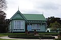
The Rotorua Museum, housed in the former Bath House building, looks over the Government Gardens. There are sports facilities, including the Blue Baths swimming pool, a bowling green, and a croquet lawn. There is also a bandstand. The Polynesian Spa is close by, beside Lake Rotorua. [1]

History

Part of the site was known to the Māori people as Paepaehakumanu and the northern part as Motutara. [2] The area known as Paepaehakumanu was a bird-snaring ground, which led to its name. [3] The area is of historical significance to the local Maori, with battles having been fought here. [1] The Maori gave 50 acres of the land to the British Crown in the late 1800s. [2] The combined Paepaehakumanu and Motutara area became known as the Sanatorium Reserve, or more commonly, the Government Gardens. [2]

The New Zealand Government opened a large bath house here in 1908. A second building, the Blue Baths, opened in 1933, amidst much controversy, as mixed bathing was accommodated. [1] [4] The Blue Baths were closed in 1982, and restored in 1999–2000. [5] The original 1908 Bath House closed to bathing in 1966. The building was extensively renovated in 1995 and converted into a museum. [6]

Heritage registrations

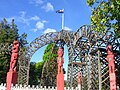
A number of items are covered by formal registrations by Heritage New Zealand. The former Bath House, now Rotorua Museum, and the Blue Baths have Category I registrations. [6] [5] Four structures have Category II registrations, including the Prince's Arch and Gateway which was built for the 1901 royal visit of the Duke and Duchess of York; this structure is now unique in New Zealand. [7] [8] [9] [10] The area as a whole is also covered by a Historic Area registration. [2]

PhotoNameCategoryDescription
2000 New Zealand 19.jpg Former Bath House, now Rotorua Museum Category I half-timbered Elizabethan Revival building [6]
Blue Baths 089.jpg Blue Baths Category ISpanish Mission-style bath house [5]
Prince's Arch and Gateway 0456 09.jpg Prince's Arch and GatewayCategory IIarchway resembling a royal crown built for the royal visit in 1901 [7]
Te Runanga Tea Pavilion and Ticket Office 061.jpg Te Runanga Tea Pavilion and Ticket OfficeCategory IItea kiosk and an adjacent small octagonal building that served as a ticket office [8]
Rotunda, Rotorua 064.jpg RotundaCategory IIband rotunda [9]
Gardener's Cottage, Rotorua 128.jpg Gardener's CottageCategory IIcottage for the reserve's gardener [10]
Rotorua Museum - view from the top 2016-01-24.jpg Rotorua Government GardensHistoric Areaheritage registration covering the whole setting [2]
Arawa War Memorial.jpg Arawa War Memorial Historic Monument World War I memorial by William Henry Feldon unveiled in 1927 by the Duke of York (later King George VI.) [11]

Related Research Articles

<span class="mw-page-title-main">Rotorua</span> City in Bay of Plenty, New Zealand

Rotorua is a city in the Bay of Plenty Region of New Zealand's North Island. It is sited on the southern shores of Lake Rotorua, from which it takes its name. It is the seat of the Rotorua Lakes District, a territorial authority encompassing Rotorua and several other nearby towns. It has an estimated resident population of 58,900, making it the country's 13th largest urban area, and the Bay of Plenty's second-largest urban area behind Tauranga.

<span class="mw-page-title-main">New Zealand Parliament Buildings</span> Government complex in Wellington, New Zealand

New Zealand Parliament Buildings house the New Zealand Parliament and are on a 45,000 square metre site at the northern end of Lambton Quay, Wellington. From north to south, they are the Parliamentary Library building (1899); the Edwardian neoclassical-style Parliament House (1922); the executive wing, called "The Beehive" (1977); and Bowen House. Whilst most of the individual buildings are outstanding for different reasons, the overall setting that has been achieved "has little aesthetic or architectural coherence".

<span class="mw-page-title-main">Sydenham, New Zealand</span> Suburb of Christchurch, New Zealand

Sydenham is an inner suburb of Christchurch, New Zealand, two kilometres south of the city centre, on and around the city's main street, Colombo Street. It is a residential, retail and light industrial suburb.

<span class="mw-page-title-main">Heritage New Zealand</span> Crown entity of New Zealand

Heritage New Zealand Pouhere Taonga is a Crown entity with a membership of around 20,000 people that advocates for the protection of ancestral sites and heritage buildings in New Zealand. It was set up through the Historic Places Act 1954 with a mission to "...promote the identification, protection, preservation and conservation of the historical and cultural heritage of New Zealand" and is an autonomous Crown entity. Its current enabling legislation is the Heritage New Zealand Pouhere Taonga Act 2014.

<span class="mw-page-title-main">Heretaunga Street</span>

Heretaunga Street is the main arterial road through Hastings, New Zealand. The street forms the heart of the Central Business District of Hastings City across six blocks numbered 100, 200, and 300 Blocks with the railway line dividing the blocks by East and West. The name Heretaunga is taken from the name of the Māori Land Block on which Hastings was established in 1873.

<span class="mw-page-title-main">Moutoa Gardens</span>

Moutoa Gardens, also known as Pākaitore, is a park in the city of Whanganui, New Zealand. Named after the Battle of Moutoa Island in the Second Taranaki War, it contains a memorial to the battle inscribed "To the memory of the brave men who fell at Moutoa, 14 May 1864, in defence of law and order against fanaticism and barbarism." It also contained a statue of John Ballance, organiser of a volunteer cavalry troop in Tītokowaru's War and later Premier of New Zealand, but the statue was beheaded and a replacement installed outside the district council building. A number of items present in the park are registered by Heritage New Zealand.

Polynesian Spa is a developed geothermal spa facility in Rotorua, North Island, New Zealand.

<span class="mw-page-title-main">Rotorua Museum</span> Museum in Rotorua, New Zealand

The Rotorua Museum Te Whare Taonga o Te Arawa is a local museum and art gallery in the Government Gardens near the centre of Rotorua, New Zealand.

<span class="mw-page-title-main">Governors Bay</span> Settlement in Christchurch, New Zealand

Governors Bay is a small town in Canterbury, New Zealand.

<span class="mw-page-title-main">Symonds Street</span> Street in Auckland, New Zealand

Symonds Street is a street in Auckland, New Zealand's most populous city. The road runs southwest and uphill from the top of Anzac Avenue, through the City Campus of University of Auckland, over the Northwestern Motorway and Auckland Southern Motorway and to the start of New North Road and Mount Eden Road.

<span class="mw-page-title-main">Appleby, New Zealand</span> Locality in Tasman District, New Zealand

Appleby is a locality in the Tasman district in the South Island of New Zealand. It is located around the Waimea River near the Tasman Bay / Te Tai-o-Aorere. It was first settled in the early 1840s. State Highway 60 passes through the settlement.

<span class="mw-page-title-main">Smelting House ruins</span>

The Smelting House ruins on Kawau Island, New Zealand, belong to the copper mine established in 1844. As there were problems with combustion of the copper ore during the sea voyage to Wales or Australia, tenders were called in 1848 for the erection of a copper mine smelter. The Auckland architect Walter Robertson designed a simple building completely built of Waitematā sandstone. Opened in July 1849, it was New Zealand's first smelting house. The smelter was no longer functioning in September 1855, and shortly after that, the mine closed altogether.

<span class="mw-page-title-main">Registry Building</span>

The Registry Building belongs to the Christchurch Arts Centre in the Christchurch Central City of Christchurch, New Zealand. It is covered by a Category I registration by Heritage New Zealand that is separate to the Category I registration that covers the buildings in the western part of the block, and the Category II registration that applies to the former Student Union building. Designed by Collins and Harman, the Registry Building was constructed in 1916 and an extension was added ten years later. After the 2011 Christchurch earthquake, 22 of the historic buildings were red stickered. The Registry Building was the first one to be restored, and it reopened in July 2013.

<span class="mw-page-title-main">Queens Gardens, Dunedin</span>

Queens Gardens is a roughly triangular area of trees and lawn in central Dunedin, New Zealand.

<span class="mw-page-title-main">Victoria, Rotorua</span> Suburb of Rotorua, New Zealand

Victoria is a suburb of Rotorua in the Bay of Plenty Region of New Zealand's North Island.

<span class="mw-page-title-main">Tauranga Central</span> Central Business District of Tauranga, New Zealand

Tauranga Central is a suburb and the central business district of Tauranga, in the Bay of Plenty Region of New Zealand's North Island.

<span class="mw-page-title-main">Hobson Street, Auckland</span>

Hobson Street is the major street in Auckland, New Zealand. It lies on the western side of Queen Street. It is a commercial and high-rise residential street, and provides access to the Auckland Northern Motorway going south, and the Northwest Motorway going west. For most of its length it is one-way. One block to the west is Nelson Street, which is one-way in the other direction and provides access to the central city for traffic exiting from the motorways. One block to the east is Albert Street, part of Mayoral Drive, and Vincent Street. The area encompassed by these streets is called Hobson Ridge by Statistics New Zealand.

<span class="mw-page-title-main">Shortland Street, Auckland</span> Street in Auckland, New Zealand

Shortland Street was the initial commercial street of Auckland and remains a key financial and legal centre for Auckland city. It runs east from Queen Street up to Princes Street, providing a connection from the business district to the Auckland High Court and University of Auckland.

<span class="mw-page-title-main">Blue Baths</span>

The Blue Baths is a heritage geothermal baths building in Rotorua, in the North Island of New Zealand. The building is designed in the Spanish Mission style. It is listed as a Category 1 Historic Place by Heritage New Zealand.

References

  1. 1 2 3 "Government Gardens". Tourism New Zealand . Retrieved 10 July 2016.
  2. 1 2 3 4 5 "Rotorua Government Gardens Historic Area". New Zealand Heritage List/Rārangi Kōrero. Heritage New Zealand . Retrieved 10 July 2016.
  3. "Rotorua historical site receives Waahi Tapu status" (Press release). Destination Rotorua Marketing. 8 March 2012. Retrieved 31 August 2019 via Scoop.
  4. Utiger, Taryn (29 January 2015). "Ancient history, new beginnings in Rotorua". Stuff.co.nz . Retrieved 10 July 2016.
  5. 1 2 3 "Blue Baths". New Zealand Heritage List/Rārangi Kōrero. Heritage New Zealand . Retrieved 10 July 2016.
  6. 1 2 3 "The Bath House (Former)". New Zealand Heritage List/Rārangi Kōrero. Heritage New Zealand . Retrieved 10 July 2016.
  7. 1 2 "Prince's Arch and Gateway". New Zealand Heritage List/Rārangi Kōrero. Heritage New Zealand . Retrieved 10 July 2016.
  8. 1 2 "Te Runanga Tea Pavilion and Ticket Office (Former)". New Zealand Heritage List/Rārangi Kōrero. Heritage New Zealand . Retrieved 10 July 2016.
  9. 1 2 "Rotunda". New Zealand Heritage List/Rārangi Kōrero. Heritage New Zealand . Retrieved 10 July 2016.
  10. 1 2 "Gardener's Cottage (Former)". New Zealand Heritage List/Rārangi Kōrero. Heritage New Zealand . Retrieved 10 July 2016.
  11. "Arawa war memorial, Rotorua | NZHistory, New Zealand history online". nzhistory.govt.nz. Retrieved 7 September 2019.

38°08′06″S176°15′29″E / 38.13500°S 176.25806°E / -38.13500; 176.25806