Graah Mountains | |
---|---|
Graah Fjelde | |
Highest point | |
Elevation | 1,887 m (6,191 ft) |
Geography | |
Country | Greenland |
Range coordinates | 61°0′N43°0′W / 61.000°N 43.000°W Coordinates: 61°0′N43°0′W / 61.000°N 43.000°W |
The Graah Mountains (Danish : Graah Fjelde or Graah Bjerge) [1] are a mountain range in southeastern Greenland. Administratively this range is part of the Kujalleq municipality.
Danish is a North Germanic language spoken by around six million people, principally in Denmark and in the region of Southern Schleswig in northern Germany, where it has minority language status. Also, minor Danish-speaking communities are found in Norway, Sweden, Spain, the United States, Canada, Brazil, and Argentina. Due to immigration and language shift in urban areas, around 15–20% of the population of Greenland speak Danish as their first language.
A mountain range or hill range is a series of mountains or hills ranged in a line and connected by high ground. A mountain system or mountain belt is a group of mountain ranges with similarity in form, structure, and alignment that have arisen from the same cause, usually an orogeny. Mountain ranges are formed by a variety of geological processes, but most of the significant ones on Earth are the result of plate tectonics. Mountain ranges are also found on many planetary mass objects in the Solar System and are likely a feature of most terrestrial planets.
Greenland is an autonomous constituent country of the Danish Realm, located between the Arctic and Atlantic oceans, east of the Canadian Arctic Archipelago. Though physiographically a part of the continent of North America, Greenland has been politically and culturally associated with Europe for more than a millennium. The majority of its residents are Inuit, whose ancestors began migrating from the Canadian mainland in the 13th century, gradually settling across the island.
This mountain group was named after Wilhelm August Graah, who described them for the first time during his 1829 expedition to the little known eastern coast of Greenland in search of the lost Eastern Norse Settlement. [2] The area of the range is currently uninhabited.
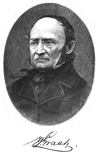
Wilhelm August Graah (1793–1863) was a Danish naval officer and Arctic explorer. Graah had mapped areas of West Greenland when he, in 1828–30, was sent by King Frederick VI of Denmark on an expedition to the unmapped eastern coast with the purpose to search for the lost Eastern Norse Settlement.
The Graah Mountains are relatively little glaciated craggy and steep nunataks rising above the glaciers in the King Frederick VI Coast. The range runs roughly from east to west from the Irminger Sea coast to the Greenland ice sheet west of Kangerluk Fjord, between Kangerluluk Fjord in the north and Iluileq Fjord (Danell Fjord) in the south. The highest elevation of the range is located at its western end close to the head of Iluileq Fjord, at 61°0′55″N43°37′53″W / 61.01528°N 43.63139°W . [3]
A nunatak is an exposed, often rocky element of a ridge, mountain, or peak not covered with ice or snow within an ice field or glacier. They are also called glacial islands. Examples are natural pyramidal peaks. When rounded by glacial action, smaller rock promontories may be referred to as rognons.
King Frederick VI Coast is a major geographic division of Greenland. It comprises the coastal area of Southeastern Greenland in Sermersooq and Kujalleq municipalities fronting the Irminger Sea of the North Atlantic Ocean. It is bordered by King Christian IX Land on the north and the Greenland Ice Sheet to the west.
The Irminger Sea is a marginal sea of the North Atlantic Ocean.
Graah described this group of mountains from the coast in the following terms:
Above those glaciers, however, rises a chain of mountains, forming a solitary exception to the uniform appearance of the country round, and no less remarkable for their beauty of contour, than for their height, which, I should think, must be upwards of 3000 feet, while the rest of the country, hereabouts, falls considerably short of half that elevation. [2]
Amphibolite is a metamorphic rock that contains amphibole, especially the species hornblende and actinolite, as well as plagioclase.
Greenland is located between the Arctic Ocean and the North Atlantic Ocean, northeast of Canada and northwest of Iceland. The territory comprises the island of Greenland—the largest island in the world—and more than a hundred other smaller islands. As an island, Greenland has no land boundaries and 44,087 km of coastline. A sparse population is confined to small settlements along certain sectors of the coast. Greenland possesses the world's second largest ice sheet.
The Watkins Range is Greenland's highest mountain range. It is located in King Christian IX Land, Sermersooq municipality.
Iluileq is an uninhabited island in the Kujalleq municipality in southern Greenland.
Napasorsuaq Fjord or Napasorsuup Kangerlua is a fjord of the King Frederick VI Coast in the Sermersooq municipality, southeastern Greenland.
Skjoldungen is a large uninhabited island in the King Frederick VI Coast, southeastern Greenland. Administratively it is part of the Sermersooq municipality. The weather of the island is characterized by tundra climate.
Thorland is a peninsula in the King Frederick VI Coast, southeastern Greenland. It is a part of the Sermersooq municipality.
Paatusoq, mentioned as 'Patursok' by Wilhelm August Graah, is a fjord in the King Frederick VI Coast, Kujalleq municipality, southeastern Greenland. Its name means "The one with the big mouth" in the Greenlandic language.
Iluileq is a fjord in the King Frederick VI Coast, Kujalleq municipality, southern Greenland.
Kangerluluk, old spelling Kangerdluluk, meaning 'the awful fjord', is a fjord in the King Frederick VI Coast, Kujalleq municipality, southern Greenland.
Igutsaat Fjord, also known as Igutsait Fjord, is a fjord in the King Frederick VI Coast, Kujalleq municipality, southern Greenland.
Sikuijivitteq, also known as Kangerdlugsuatsiak, is a fjord of the King Frederick VI Coast in the Sermersooq municipality, southeastern Greenland. The name 'Mogens Heinesen' is based on Magnus Heinason, a 16th-century Faroese naval hero.
Sehested Fjord ) is a fjord of the King Frederick VI Coast in the Sermersooq municipality, southeastern Greenland.
Mount Paatusoq, also known as 'Mount Patuersoq', is the highest mountain in the Kujalleq municipality, SE Greenland.
Schweizerland, also known as Schweizerland Alps, is a mountain range in King Christian IX Land, eastern Greenland. Administratively this range is part of the Sermersooq Municipality. Its highest point is one of the highest peaks in Greenland.
Odinland, also Odinsland in the Defense Mapping Agency Greenland Navigation charts, is a peninsula in the King Frederick VI Coast, southeastern Greenland. It is a part of the Sermersooq municipality.
The Lindbergh Range or Lindbergh Nunataks is a mountain range in King Christian IX Land, eastern Greenland. Administratively this range is part of the Sermersooq Municipality.
Cape Discord, also known as Kangeq, is a headland in the North Atlantic Ocean, southeast Greenland, Kujalleq municipality.
Kangerluk, also known as Kangerluluarak, is a fjord in the King Frederick VI Coast, Kujalleq municipality, southern Greenland.
This Greenland location article is a stub. You can help Wikipedia by expanding it. |