
The Zugspitze, at 2,962 m (9,718 ft) above sea level, is the highest peak of the Wetterstein Mountains and the highest mountain in Germany. It lies south of the town of Garmisch-Partenkirchen in Bavaria, and the Austria–Germany border is on its western summit. South of the mountain is the Zugspitzplatt, a high karst plateau with numerous caves. On the flanks of the Zugspitze are two glaciers, the largest in Germany: the Northern Schneeferner with an area of 30.7 hectares and Höllentalferner with an area of 24.7 hectares. Shrinking of the Southern Schneeferner led to the loss of glacier status in 2022.
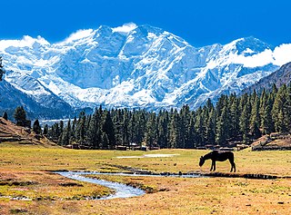
Nanga Parbat, known locally as Diamer, is the ninth-highest mountain on Earth and its summit is at 8,126 m (26,660 ft) above sea level. Lying immediately southeast of the northernmost bend of the Indus River in the Gilgit-Baltistan region of Pakistan-administered Kashmir, Nanga Parbat is the westernmost major peak of the Himalayas, and thus in the traditional view of the Himalayas as bounded by the Indus and Yarlung Tsangpo/Brahmaputra rivers, it is the western anchor of the entire mountain range.

Piz Buin is a mountain in the Silvretta range of the Alps on the border between Austria and Switzerland. It forms the border between the Swiss canton of Graubünden and the Austrian state of Vorarlberg and is the highest peak in Vorarlberg.

Sgùrr nan Gillean is a peak in the northern part of the Cuillin mountains on the Isle of Skye in Scotland. With a height of 966 metres, it is one of eleven Munros in the Cuillins. It is the Munro peak nearest to the settlement of Sligachan, and its impressive triangular profile makes it one of the most recognizable of the Cuillins.

Pillar is a mountain in the western part of the English Lake District. Situated between the valleys of Ennerdale to the north and Wasdale to the south, it is the highest point of the Pillar group. At 892 metres (2,927 ft) it is the eighth-highest mountain in the Lake District. The fell takes its name from Pillar Rock, a prominent feature on the Ennerdale side, regarded as the birthplace of rock climbing in the district.

Toubkal, also Jbel Toubkal or Jebel Toubkal, is a mountain in southwestern Morocco, located in the Toubkal National Park. At 4,167 m (13,671 ft), it is the highest peak in Morocco, the Atlas Mountains, North Africa and the Arab world. Located 63 km (39 mi) south of the city of Marrakesh, and visible from it, Toubkal is an ultra prominent peak, the highest for over 2,000 km (1,200 mi). Toubkal is ranked 27th by topographic isolation.

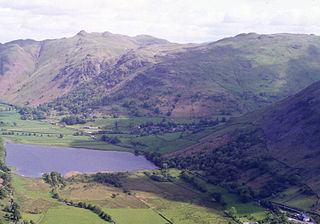
Place Fell is a mountain in the English Lake District. It stands at the corner of the upper and middle reaches of Ullswater, with steep western flanks overlooking the villages of Glenridding and Patterdale.

The Dom is a mountain of the Pennine Alps, located between Randa and Saas-Fee in the canton of Valais in Switzerland. With a height of 4,546 m (14,915 ft), it is the seventh highest summit in the Alps, overall. Based on prominence, it can be regarded as the third highest mountain in the Alps, and the second highest in Switzerland, after Monte Rosa. The Dom is the main summit of the Mischabel group, which is the highest massif lying entirely in Switzerland.
High Stile is a mountain in the western part of the Lake District in North West England. It is the eleventh-highest English Marilyn, standing 807 metres (2,648 ft) high, and has a relative height of 362 metres (1,188 ft).
Green Gable is a fell in the English Lake District often traversed by walkers en route to its more famous neighbour Great Gable. It can be ascended from Honister Pass, Seathwaite in Borrowdale, or Ennerdale. There are good views of Gable Crag, Scafell Pike and the Buttermere valley from the summit.
Yewbarrow is a fell, in the English Lake District, which lies immediately north of the head of Wast Water. It is 628 metres high and in shape resembles the upturned hull of a boat or a barrow. Yewbarrow is on the left in the classic view of Great Gable and Wast Water.
Brock Crags is a fell in the English Lake District, standing above Hartsop in the Far Eastern Fells. It forms part of the perimeter of Martindale, lying on the long ridge from Rampsgill Head to Place Fell.
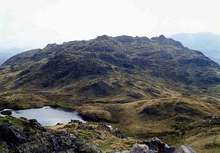
Rosthwaite Fell is a fell in the English Lake District. It is situated some 12 kilometres due south of Keswick and 2 kilometres south of the village of Rosthwaite in Borrowdale.

Long Side is a fell in the English Lake District, it is situated six kilometres north west of Keswick in the northern sector of the national park and is part of the Skiddaw group of fells. Long Side which reaches a height of 734 metres (2,408 ft) is located on Skiddaw’s north western ridge, the middle section of which is known as Longside Edge. Strictly speaking the actual summit of the fell is nameless with the name Long Side applying to the south western slope below the summit and is so marked on maps. The fell is often climbed by walkers on their way to the summit of Skiddaw, the route up the north west ridge which passes over Long Side is regarded as being the finest and quietest ascent of that 3,000-foot (910 m) mountain by guide book writers.

Càrn a' Mhàim is a Scottish mountain situated in the inner part of the Cairngorms range, some 15 kilometres west of Braemar in the county of Aberdeenshire.

Gairich, sometimes Sgurr Gairoch, is a mountain in Lochaber in the Northwest Highlands of Scotland. It is on the southern side of Loch Quoich, with Glen Garry to the east and Glen Kingie to the south, 25 kilometres north-northwest of Fort William.

Am Bàthach is a Scottish mountain situated at the head of Glen Shiel, at the western end of Loch Cluanie some 38 km (24 mi) south east of Kyle of Lochalsh.

Balsam Mountain is one of the High Peaks of the Catskill Mountains in the U.S. state of New York. Its exact height has not been determined, so the highest contour line, 3,600 feet (1,100 m), is usually given as its elevation. It is located in western Ulster County, on the divide between the Hudson and Delaware watersheds. The summit and western slopes of the peak are within the Town of Hardenburgh and its eastern slopes are in Shandaken. The small community of Oliverea is near its base on that side. Most of the mountain is publicly owned, managed by the New York State Department of Environmental Conservation as part of the state Forest Preserve, part of the Big Indian-Beaverkill Range Wilderness Area in the Catskill Park. The summit is on a small corner of private land.

The Rauhkofel or Rauchkofel is a summit on the main crest of the Zillertal Alps, which forms the border between the Austrian state of Tyrol and the Italian province of South Tyrol. The name of the mountain comes from the rugged appearance of the granite blocks that form the summit. The Rauhkofel rises above its neighbouring peaks on the main Zillertal ridge considerably and it is considered the best lookout mountain in the eastern Zillertal Alps. The east and south arêtes of the Rauhkofel are part of the main crest of the Zillertal Alps. Another ridge runs from the summit heading northwest; on its continuation at a distance of just under two kilometres is the Kleinspitze. North of the summit are the remnants of the Rauhkofelkees glacier. At the southwestern foot of the peak is the Waldner See, the largest lake in the Ahrntal valley.

Monte Alben, with a height of 2019 m above sea level, is a mountain in the Bergamasque Prealps, located along the ridge separating the Brembana Valley from the Seriana Valley, in the province of Bergamo.

