Moka is a village in Mauritius located mainly in the Moka District. The western part of the village lies in the Plaines Wilhems District. Since 1967 it forms part of Constituency No. 8 Quartier Militaire and Moka. The village is administered by the Moka Village Council under the aegis of the Moka District Council. According to the census made by Statistics Mauritius in 2011, the population was at 8,846. The elevation is 203 meters and can be up to 425 meters in some places. Moka is directly on the other side of the Moka Range from Port Louis. The village is close to the mountain Le Pouce and the town Beau-Bassin Rose-Hill. Réduit is a suburb of the village where the State House and University of Mauritius is situated. The village is also home to the Mauritius Broadcasting Corporation and the Mahatma Gandhi Institute.

The Mascarene Islands or Mascarenes or Mascarenhas Archipelago is a group of islands in the Indian Ocean east of Madagascar consisting of islands belonging to the Republic of Mauritius as well as the French department of La Réunion. Their name derives from the Portuguese navigator Pedro Mascarenhas, who first visited them in April 1512. The islands share a common geological origin beneath the Mascarene Plateau known as the Mauritia microcontinent which was a Precambrian microcontinent situated between India and Madagascar until their separation about 70 million years ago. They form a distinct ecoregion with unique biodiversity and endemism of flora and fauna.

Curepipe also known as La Ville-Lumière, is a town in Mauritius, located mainly in the Plaines Wilhems District. Its eastern part lies in the Moka District. The town is administered by the Municipal Council of Curepipe. Curepipe lies at a higher elevation, often referred to as the "Central Plateau". According to the census made by Statistics Mauritius in 2018, the population of the town was at 78,618.

Savanne or Savannah is a district of Mauritius, situated in the south of the island. The district has an area of 244.8 km2 and, as of 31 December 2015, the estimated population was 68,585. The southern part of the island is one of the most scenic and unspoilt.
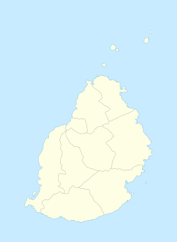
The Districts of the Republic of Mauritius are the second-level administrative divisions after the Outer Islands of Mauritius.

Quatre Bornes, also known as La Ville des Fleurs, is a town in Mauritius, located mainly in the Plaines Wilhems District. Its western part lies in the Rivière Noire District. The town is administered by the Municipal Council of Quatre Bornes. Situated between the towns of Beau-Bassin Rose-Hill and Vacoas-Phoenix, Quatre Bornes is linked by roads to the north, east, south and west of Mauritius. According to the census made by Statistics Mauritius in 2015, the population of the town was at 77,308.

Beau Bassin-Rose Hill is a town in Mauritius, located in the Plaines Wilhems District. It is administered by the Municipal Council of Beau Bassin-Rose Hill and has a population of 147,066 inhabitants, making it the third largest city on the island.
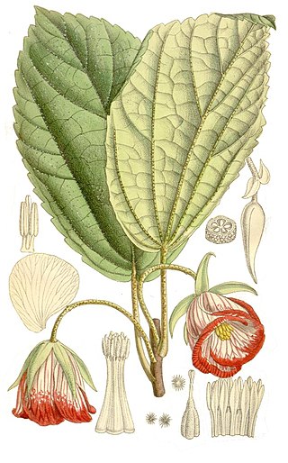
Trochetia is a genus of flowering plants from the family Malvaceae. They are endemic to the Mascarene Islands.

Trou aux Cerfs is a dormant, crater lake, cinder cone volcano with a well-defined cone and crater. It is 605 m (1,985 ft) high and located in Curepipe, Mauritius. The crater has been alternately described as 300 and 350 meters in diameter, and is 80 meters deep.
The Islets of Mauritius include circa 130 tiny islets and rocks scattered around the coast of Mauritius, Rodrigues, Agalega and St Brandon.

Constituencies of Mauritius are the electoral boundaries within the Republic of Mauritius. They are also commonly referred to as Circonscriptions amongst the locals. The country follows the Westminster system and elects 60 members of parliament for a term of 5 years. There are in all 21 Constituencies in the republic, each of them returning 3 members with the exception of Constituency n°21, which returns only 2 members. The Constitution stipulates that there shall be 20 constituencies and one created specially for the Rodrigues island.
Pritam Singh Mattan, born in Mauritius in the village of Bois Cheri, was rather briefly the Chief Executive of Rodrigues Island, Mauritius, from March 5 until August 24, 2010. Prior to this, he was the head of the island's Commission for Tourism since August 2006 and the Director of Rodrigues Tourism Office and Discovery Rodrigues Co Ltd. He worked in different managerial positions in the private and public sector in Mauritius in organizations such as the Compagnie Mauricienne De Textile Ltee, the Grand Port Savanne District Council, the Sugar Insurance Fund Board and the Wastewater Management Authority, before taking employment in Rodrigues with the Rodrigues Regional Assembly. He has a master's degree in Business Administration from the University of Mauritius. He also did his undergraduate studies in Management at the University of Mauritius where he topped his batch and faculty in 1997 and was awarded several bursaries and scholarships. He is also the co-founder of the Revengers Sports Club of Bois Cheri which plays football in the regional football league of Savanne in Mauritius.

Plaine Magnien is a village in southeast Mauritius located in the Grand Port District.
Rivière Du Poste is a village in the southern part of Mauritius located in both Savanne and Grand Port districts. The locality is about 19 miles south of Port Louis, the nation's capital. The village is administered by the Rivière du Poste Village Council under the aegis of the Savanne District Council. According to the census made by Statistics Mauritius in 2011, the population was 2,170. The neighboring villages are La Flora, Mare Tabac and Rose Belle and Camp Diable and Riviere Dragon in the south of the village.

The communal section is the smallest administrative division in Haiti. The 144 communes are further divided into 571 communal sections.

Prithvirajsing Roopun GCSK is a Mauritian politician serving as the seventh president of Mauritius since 2019.

Sir Satcam Boolell GCSK QC was a Mauritian politician who served as member of the Legislative Assembly in Mauritius. He died on 23 March 2006, in Curepipe. He was also known as "Somduth" by his peers and family members.
Paramhamsa Nababsing, more commonly known as Prem Nababsing, was a Mauritian politician and MMM minister.
Kailesh Kumar Singh Jagutpal, more commonly known as Kailesh Jagutpal is a Mauritian politician.