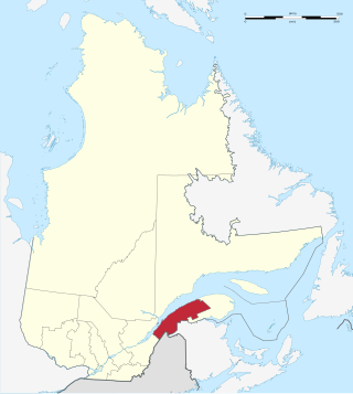
The Bas-Saint-Laurent is an administrative region of Quebec located along the south shore of the lower Saint Lawrence River in Quebec. The river widens at this place, later becoming a bay that discharges into the Atlantic Ocean and is often nicknamed "Bas-du-Fleuve" (Lower-River). The region is formed by eight regional county municipalities and 114 municipalities. In the south, it borders Maine of the United States, and the Canadian New Brunswick and the regions of Chaudière-Appalaches and Gaspésie–Îles-de-la-Madeleine.

The Mascarene Islands or Mascarenes or Mascarenhas Archipelago is a group of islands in the Indian Ocean east of Madagascar consisting of islands belonging to the Republic of Mauritius as well as the French department of La Réunion. Their name derives from the Portuguese navigator Pedro Mascarenhas, who first visited them in April 1512. The islands share a common geological origin beneath the Mascarene Plateau known as the Mauritia microcontinent which was a Precambrian microcontinent situated between India and Madagascar until their separation about 70 million years ago. They form a distinct ecoregion with unique biodiversity and endemism of flora and fauna.

Curepipe also known as La Ville-Lumière, is a town in Mauritius, located mainly in the Plaines Wilhems District. Its eastern part lies in the Moka District. The town is administered by the Municipal Council of Curepipe. Curepipe lies at a higher elevation, often referred to as the "Central Plateau". According to the census made by Statistics Mauritius in 2018, the population of the town was at 78,618.
The Districts of the Republic of Mauritius are the second-level administrative divisions after the Outer Islands of Mauritius.

Pamplemousses is a district of Mauritius, located in the northwest of the island, and is one of the most densely populated parts of the island. The name of the district comes from the French word for grapefruits. The district has an area of 178.7 km2 and an estimated population of 139,966, as of 31 December 2015.

Rivière du Rempart is a district of Mauritius, located in the north-east of the island. It has an area of 147.6 km² and an estimated population of 108,005, as of 31 December 2015.

Mapou is a village in northern Mauritius, located in Rivière du Rempart District. The village is administered by the Mapou Village Council under the aegis of the Rivière du Rempart District Council. According to the census by Statistics Mauritius in 2011, the population was 1,275.

Rivière Noire or Black River is a district on the western side of the island of Mauritius. Rivière Noire translates to Black River. This region receives less rainfall than the others. The district has an area of 259 square kilometres (100 sq mi) and the population was estimated to be 80,939 as of 31 December 2015. It is the third largest district of Mauritius in area, but the smallest in terms of population. The district is mostly rural, but it also include the western part of the city of Port Louis and western part of Quatre Bornes.
The Islets of Mauritius include circa 130 tiny islets and rocks scattered around the coast of Mauritius, Rodrigues, Agalega and St Brandon.
The wildlife of Mauritius consists of its flora and fauna. Mauritius is located in the Indian Ocean to the east of Madagascar. Due to its isolation, it has a relatively low diversity of wildlife; however, a high proportion of these are endemic species occurring nowhere else in the world. Many of these are now threatened with extinction because of human activities including habitat destruction and the introduction of non-native species. Some have already become extinct, most famously the dodo which disappeared in the 17th century.

Grand Baie is a coastal village in Mauritius located mainly in the Rivière du Rempart District. The western part of the village lies inside the Pamplemousses District. The village is administered by the Grand Baie Village Council under the aegis of the Rivière du Rempart District Council. According to the census by Statistics Mauritius in 2011, the population was at 11,910.
Bel-Ombre is a village in Mauritius located in Savanne District. The village is administered by the Bel-Ombre Village Council under the aegis of the Savanne District Council. According to the 2011 census by Statistics Mauritius, the population was 2,417.

Chamarel is a village in Mauritius mainly located in Rivière Noire District. The eastern part of the village lies in the Savanne District. The village is administered by the Chamarel Village Council under the aegis of the Rivière Noire District Council.
Rivière Du Poste is a village in the southern part of Mauritius located in both Savanne and Grand Port districts. The locality is about 19 miles south of Port Louis, the nation's capital. The village is administered by the Rivière du Poste Village Council under the aegis of the Savanne District Council. According to the census made by Statistics Mauritius in 2011, the population was 2,170. The neighboring villages are La Flora, Mare Tabac and Rose Belle and Camp Diable and Riviere Dragon in the south of the village.
The 2018 MFA Cup is the 47th edition of the MFA Cup, the knockout football competition of Mauritius.
Kailesh Kumar Singh Jagutpal, more commonly known as Kailesh Jagutpal is a Mauritian politician.
Grand Bois is a village located in the Savanne District of Mauritius. According to the 2015 census by Statistics Mauritius, the population was 7,982.


