This is a list of the lists of islands in the world grouped by country, by continent, by body of water, and by other classifications. For rank-order lists, see the other lists of islands below.

Seychelles is a small island country east of the African continent's mainland located in the Sea of Zanj due north of Madagascar, with Antsiranana as its nearest foreign city. Seychelles lies between approximately 4ºS and 10ºS and 46ºE and 54ºE. The nation is an archipelago of 155 tropical islands, some granite and some coral. the majority of which are small and uninhabited. The landmass is only 452 km2 (175 sq mi), but the islands are spread wide over an exclusive economic zone of 1,336,559 km2 (516,048 sq mi). About 90 percent of the population of 100,000 live on Mahé, 9 percent on Praslin and La Digue. Around a third of the land area is the island of Mahé and a further third the atoll of Aldabra.

The Mascarene Islands or Mascarenes or Mascarenhas Archipelago is a group of islands in the Indian Ocean east of Madagascar consisting of the islands belonging to the Republic of Mauritius as well as the French department of La Réunion. Their name derives from the Portuguese navigator Pedro Mascarenhas, who first visited them in April 1512. The islands share a common geologic origin in the volcanism of the Réunion hotspot beneath the Mascarene Plateau and form a distinct ecoregion with a unique flora and fauna.

The Réunion hotspot is a volcanic hotspot which currently lies under the island of Réunion in the Indian Ocean. The Chagos-Laccadive Ridge and the southern part of the Mascarene Plateau are volcanic traces of the Réunion hotspot.
Saint Brandon, also known as the Cargados Carajos Shoals, is an Indian Ocean archipelago of sand banks, shoals and islets belonging to Mauritius. It lies about 430 km (270 mi) northeast of the island of Mauritius. It consists of five island groups, with about 28-40 islands and islets in total, depending on seasonal storms and related sand movements.


Speakers Bank is a large coral atoll structure in the Northwestern part of the Chagos Archipelago. It is the northernmost feature of the archipelago, located at 04°55′S72°20′E, 22 km Northwest of Blenheim Reef and is 44 km Northeast-Southwest, and 24 km wide. The total area is 582 km2, most of which is water. Most of the rim of the reef is between 5.5 and 14.5 metres below water. In the south, near the southwest edge, there are some coral heads at 05°04'S, 072°16'E, 0.5 metres of which are dry during low tide, and over which the sea breaks heavily during the southeast trade winds. In the Northeast, at 04°47'S, 072°26'E, there are a number of drying cays, the biggest of which, Big Speaker Reef, just reaches the high water mark. The land area is negligible.
The Soudan Banks are a series of underwater high points and reefs off the coast of Africa, known for their good fishing yields as fishing banks. They are administered by Mauritius. The five banks lie on the Mascarene plateau. North Soudan contains large salmon stocks. South Soudan is the largest of the banks, with many reefs and passes. West Soudan is small, rocky, and shallow, and is the least fished of the banks. Central Soudan is the most fished area, with huge reefs and open waters containing a huge abundance of fish. East Soudan, until the 1970s, was considered to be a completely different formation altogether, since it is located more than 100 miles away from the other banks. The other banks are closely linked, separated by small shallows or channels.
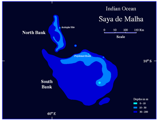
Sepia mascarensis is a species of cuttlefish native to the western Indian Ocean, specifically Saya-de-Malha Bank, Mascarene Ridge, and Cargados-Carajos Shoals. It lives at depths of between 87 and 325 m.
Hawkins Bank is a large submerged bank off the Mascarene Plateau. It is considered a dependency of Mauritius. The bank is abundant with fish and Mauritian vessels often fish in the waters in and around the bank.

Cylindraspis is a genus of recently extinct giant tortoises. All of its species lived in the Mascarene Islands in the Indian Ocean and all are now extinct due to hunting and introduction of non-native predators.

The Central Indian Ridge (CIR) is a north–south-trending mid-ocean ridge in the western Indian Ocean.
The Saya de Malha luminous roughy is a species of slimehead that is native to Saya de Malha in the Indian Ocean, the Kyushu–Palau Ridge in the Pacific Ocean, and the Nazareth Banks in the Mediterranean. Found at depths ranging from 143 to 274 m, it can reach up to 9.6 cm (3.8 in) in size.
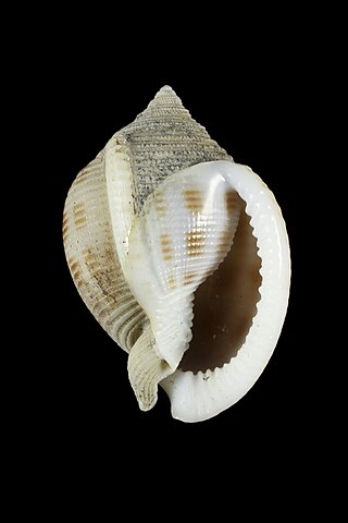
Semicassis bondarevi is a species of marine gastropod in the family Cassidae.
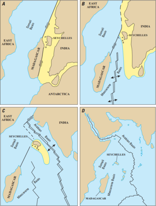
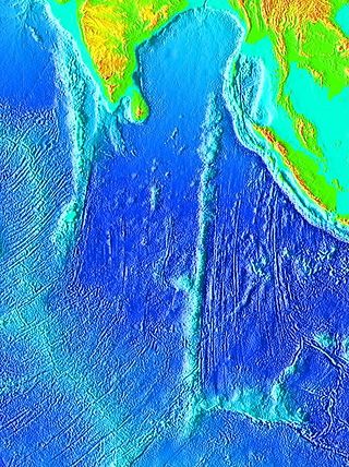
The Mascarene Basin is an oceanic basin in the western Indian Ocean. It was formed as the tectonic plate of the Indian subcontinent pulled away from the Madagascar Plate about 66–90 Mya, following the breaking up of the Gondwana supercontinent.