The Bois de Vincennes, located on the eastern edge of Paris, France, is the largest public park in the city. It was created between 1855 and 1866 by Emperor Napoleon III.

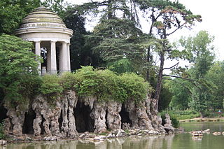
The Bois de Boulogne is a large public park that is the western half of the 16th arrondissement of Paris, near the suburb of Boulogne-Billancourt and Neuilly-sur-Seine. The land was ceded to the city of Paris by the Emperor Napoleon III to be turned into a public park in 1852.

The Eastern Highlands, also known as the Manica Highlands, is a mountain range on the border of Zimbabwe and Mozambique. The Eastern Highlands extend north and south for about 300 kilometres (190 mi) through Zimbabwe's Manicaland Province and Mozambique's Manica Province.

The Sierras de Córdoba is a mountain range in central Argentina, located between the Pampas to the east and south and the Chaco to the north and east. Most of the range is located in Córdoba Province, except for the southwestern margin which is in San Luis Province.

Eravikulam National Park is a 97 km2 national park located along the Western Ghats in the Idukki and Ernakulam districts of Kerala in India. The park is situated between 10º05'N and 10º20' north, and 77º0' and 77º10' east and is the first national park in Kerala. It was established in 1978.

Pic Macaya National Park is one of two largest national parks of the Republic of Haiti. It is located in the country's southern peninsula, within the Massif de la Hotte. Featuring the country's last stand of virgin cloud forest, it encompasses more than 8,000 hectares. Elevations in the rugged park reach a maximum height of 2,347 meters above sea level at Pic Macaya, the second highest point in Haiti behind Pic la Selle. A majority of the park is composed of two tall peaks: Pic Macaya and Pic Formon.

Eleutherodactylus semipalmatus is a species of frog in the family Eleutherodactylidae. It is endemic to Haiti and known from the Massif de la Hotte and Massif de la Selle. Its common name is foothill robber frog. Its natural habitat is streams and their vicinity in mesic hardwood forest at elevations of 303–1,697 m (994–5,568 ft) asl.
The Massif de la Hotte is a mountain range in southwestern Haiti, on the Tiburon Peninsula. About 2.5 million years ago, Massif de la Hotte was separated from the Massif de la Selle by a deep, wide sea channel, and formed a separate island. This resulted in a hotbed of endemism in la Hottes bird, plant, and reptile communities. The Massif de la Hotte is subdivided into the Oriental la Hotte in the East, the central la Hotte and the Occidental la Hotte on the Western tip of the Tiburon peninsula. The Occidental la Hotte is relatively remote and is one of the most biologically diverse and significant areas of all of Hispaniola. It also supports some of the last stands of Haiti's dense cloud forest on its peaks.
Guadeloupe National Park is a national park in Guadeloupe, an overseas department of France located in the Leeward Islands of the eastern Caribbean region. The Grand Cul-de-Sac Marin Nature Reserve is a marine protected area adjacent to the park and administered in conjunction with it. Together, these protected areas comprise the Guadeloupe Archipelago biosphere reserve.
Morne, Morné, Mörne, etc. may refer to:
Doi Suthep–Pui National Park is a national park in Chiang Mai Province in Thailand. It includes Wat Phra That Doi Suthep, a Buddhist temple, and Bhubing Palace, the winter residence of the Thai royal family. The park is a protected area for flora, fauna, and habitat.

The wildlife of Haiti is important to the country because of its biodiversity. According to the World Conservation Monitoring Centre, Haiti is considered to be "one of the most biologically significant countries of the West Indies". With an estimated 5,600 plant species on the island of Hispaniola, some of which only occur in Haiti, 36% are considered as endemic to the island. A mountainous area country, it is situated in the western three-eighths of Hispaniola and shares a border with the Dominican Republic. There are nine life zones, from low desert to high cloud forests, as well as four mountain ranges, and hundreds of rivers and streams and the coral reefs in the seas that surround the islands. Issues of environmental damage, expanding population, deforesting and erosion are of concern; less than 2% of the original forest remains on account of deforestation. This degradation is traced from the 17th century to 19th century starting with the French colonization of the Haiti and population explosion during the 20th century and for the purpose of forestry and sugar-related industries, degraded the forests. and the environment.

The Nimba Range forms part of the southern extent of the Guinea Highlands. The highest peak is Mount Richard-Molard on the border of Côte d'Ivoire and Guinea, at 1,752 m (5,748 ft). "Mount Nimba" may refer either to Mount Richard-Molard or to the entire range. Other peaks include Grand Rochers at 1,694 m (5,558 ft), Mont Sempéré at 1,682 m (5,518 ft), Mont Piérré Richaud at 1,670 m (5,480 ft), Mont Tô at 1,675 m (5,495 ft), and Mont LeClerc 1,577 m (5,174 ft), all of them are located in Guinea. Mount Nimba Strict Nature Reserve of Guinea and Côte d'Ivoire covers significant portions of the Nimba Range.

Haiti National Trust is an international, non-governmental, and non-profit environmental organization dedicated to protecting the biodiversity of Haiti. The Haiti National Trust seeks to establish more protected areas, including national parks, and to stop the destruction of forests, which is the primary cause of species loss in Haiti. The trust also advocates protection of the country's fragile coral reefs and coastal ecosystems. It was founded in 2015 by Philippe Bayard, president and founding member of the Audubon Society of Haiti, and S. Blair Hedges, Laura H. Carnell Professor and director of the Center for Biodiversity at Temple University.

Grande Colline National Park is a national park in Haiti established on July 23, 2014 with an area of 1,510 hectares. The park contains the Grande Colline mountain range at the core of the Occidental La Hotte Massif in southwestern Haiti, west of Pic Macaya. There are five named peaks: Morne Desbarrières, Morne Grande Colline, Morne Petite Colline, Morne Grenouille, and Morne Lézard.

Deux Mamelles National Park is a national park in Haiti established on September 23, 2015 with an area of 2,265 hectares. It is located on the Tiburon Peninsula of Haiti, just west of a line connecting Les Anglais to the south and Jérémie to the north. The park circumscribes a U-shaped mountain, Morne Deux Mamelles, reaching 1,276 meters (4,186 ft) in elevation and is the highest mountain at the western end of the Tiburon Peninsula. Patches of the original (primary) forest remain at elevations above 1,000 meters (3,300 ft), growing on highly dissected limestone rock.

Pico de Tancítaro, also known as Volcán Tancítaro, is a volcanic mountain in Mexico. It is located in Tancítaro municipality in Michoacán state. It is the highest peak in Michoacán.

Wercklea hottensis is a species of Malvaceae endemic to the mountains of the Massif de la Hotte in South-Western Haiti.
Magnolia ekmanii is a species of plant. It is listed as critically endangered by the IUCN.


