The history of Trinidad and Tobago begins with the settlements of the islands by Indigenous First Peoples. Trinidad was visited by Christopher Columbus on his third voyage in 1498,, and claimed in the name of Spain. Trinidad was administered by Spanish hands until 1797, but it was largely settled by French colonists. Tobago changed hands between the British, French, Dutch, and Courlanders, but eventually ended up in British hands following the second Treaty of Paris (1814). In 1889, the two islands were incorporated into a single political entity. Trinidad and Tobago obtained its independence from the British Empire in 1962 and became a republic in 1976.

The cocoa bean or simply cocoa, also called cacao, is the dried and fully fermented seed of Theobroma cacao, the cacao tree, from which cocoa solids and cocoa butter can be extracted. Cocoa trees are native to the Amazon rainforest. They are the basis of chocolate and Mesoamerican foods including tejate, an indigenous Mexican drink.
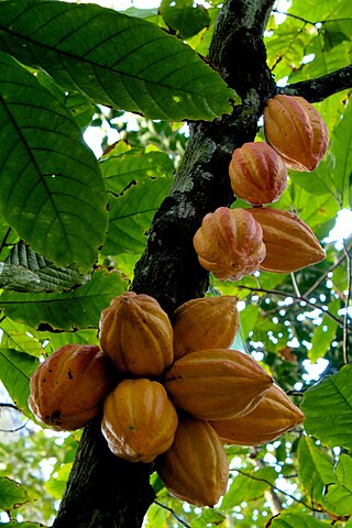
Theobroma cacao is a small evergreen tree in the family Malvaceae. Its seeds, cocoa beans, are used to make chocolate liquor, cocoa solids, cocoa butter and chocolate. Native to the tropics of the Americas, the largest producer of cocoa beans in 2018 was Ivory Coast, at 2.2 million tons. Its leaves are alternate, entire, unlobed, 10–50 cm (4–20 in) long and 5–10 cm (2–4 in) broad.

Tobago is an island and ward within the Republic of Trinidad and Tobago. It is located 35 kilometres (22 mi) northeast of the larger island of Trinidad and about 160 kilometres (99 mi) off the northeastern coast of Venezuela. It lies to the southeast of Grenada.

The leatherback sea turtle, sometimes called the lute turtle, leathery turtle or simply the luth, is the largest of all living turtles and the heaviest non-crocodilian reptile, reaching lengths of up to 2.7 metres and weights of 500 kilograms (1,100 lb). It is the only living species in the genus Dermochelys and family Dermochelyidae. It can easily be differentiated from other modern sea turtles by its lack of a bony shell; instead, its carapace is covered by oily flesh and flexible, leather-like skin, for which it is named. Leatherback turtles have a global range, although there are multiple distinct subpopulations. The species as a whole is considered vulnerable, and some of its subpopulations are critically endangered.

Trinidad is the larger and more populous of the two major islands of Trinidad and Tobago. The island lies 11 km (6.8 mi) off the northeastern coast of Venezuela and sits on the continental shelf of South America. It is often referred to as the southernmost island in the West Indies. With an area of 4,768 km2 (1,841 sq mi), it is also the fifth largest in the West Indies.
Fyzabad is a town in southwestern Trinidad, 13 km (8.1 mi) south of San Fernando, west of Siparia and northeast of Point Fortin. It is named after the town of Faizabad in India. Colloquially it is known as "Fyzo" by many people.

Sangre Grande is the largest town in northeastern Trinidad and Tobago. It is located east of Arima and southwest of the village of Toco. It is the seat of the Sangre Grande Regional Corporation and capital of the region.
Trinidad and Tobago are continental islands with a geologically very recent history of direct land bridge connection to South America. As a result, unlike most of the Caribbean Islands, Trinidad and Tobago supports a primarily South American flora and fauna and has greater diversity of plant and animal species than the Antilles. However, rates of endemism are lower than in the rest of the Caribbean because there has been less time for genetic isolation from mainland populations because of the history of land bridge connections and hence fewer opportunities for speciation, and so a greater proportion of the species in Trinidad and Tobago are also found on the South American mainland. Trinidad is nearer to mainland South America and has been directly connected to the mainland via land bridges more often and for longer periods than Tobago. This, as well as Trinidad's larger size and more varied topography and hydrology compared to that of Tobago allow greater species and ecosystem diversity on the former compared to that on the later of the islands.
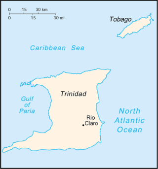
Rio Claro is the largest town in southeastern Trinidad, in Trinidad and Tobago. Rio Claro lies east of Princes Town, west of Mayaro and northwest of Guayaguayare. It serves as the major commercial centre for southeastern Trinidad. It lies in a primarily agricultural area. It is the seat of the Region of Mayaro–Rio Claro.

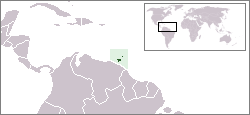
Trinidad and Tobago, officially the Republic of Trinidad and Tobago, is the southernmost island country in the Caribbean. Consisting of the main islands Trinidad and Tobago and numerous much smaller islands, it is situated 11 kilometres off the coast of northeastern Venezuela and 130 kilometres south of Grenada. It shares maritime boundaries with Barbados to the east, Grenada to the northwest and Venezuela to the south and west. Trinidad and Tobago is generally considered to be part of the West Indies. The island country's capital is Port of Spain, while its largest and most populous municipality is Chaguanas.

Playa Grande, also known as Salinas, is a beach community on the Pacific coast of Costa Rica just north of Tamarindo. It is located inside the canton of Santa Cruz in Guanacaste Province. Playa Grande has been part of the Parque Nacional Marino Las Baulas since 1990. There are palm trees and vegetation around the beach, which stretches for about 4.5 kilometers. It is part of the Las Baulas National Marine Park, which was established to protect the nesting grounds of endangered leatherback turtles. Playa Grande is one of the major nesting sites for these turtles, and visitors can witness the nesting and hatching process during the nesting season, which typically occurs from October to March. The main attraction of Playa Grande is its surf breaks. The beach has consistent waves. Playa Grande is an ideal destination for nature lovers, with diverse ecosystems surrounding it. Beyond the beach, you can explore the nearby mangrove forests, take boat tours along the estuaries, or venture into the neighboring national parks, such as Rincon de la Vieja or Santa Rosa, which offer hiking trails, wildlife spotting opportunities, and breathtaking landscapes.
Toco is the most northeasterly village on the island of Trinidad in Trinidad and Tobago. The island of Tobago is 35 kilometres (22 mi) to the northeast, making Toco the closest point in Trinidad to the sister island. The name Toco was ascribed to the area by its early Amerindian inhabitants. The meaning of the name is uncertain.
Chinese Trinidadians and Tobagonians are Trinidadians and Tobagonians of Han Chinese ancestry. The group includes people from Mainland China, Hong Kong, and Overseas Chinese who have immigrated to Trinidad and Tobago and their descendants, including those who have emigrated to other countries. The term is usually applied both to people of mixed and unmixed Chinese ancestry, although the former usually appear as mixed race in census figures. Chinese settlement began in 1806. Between 1853 and 1866 2,645 Chinese immigrants arrived in Trinidad as indentured labour for the sugar and cacao plantations. Immigration peaked in the first half of the twentieth century, but was dramatically lowered after the Chinese Communist Revolution in 1949. After peaking at 8,361 in 1960, the unmixed Chinese population in Trinidad declined to 3,800 in 2000, however slightly increased to 3,984 in 2011.

Matelot is a settlement in Trinidad and Tobago. Located on the north coast of Trinidad in the Sangre Grande region, the village has traditionally been seen as one of the most remote places on the island.
Nature Seekers is a community-based organization founded in 1990 with the aim of protecting nesting leatherback turtles in Trinidad and Tobago. The ultimate goal of the group was to reduce the problem of poaching which stood at 30 percent on a nightly basis. Through the efforts of tour guide services to visitors on Matura Beach, tagging of turtles, and patrolling the group has been able to reduce the percentage of poaching from 30 percent to zero. Now the group has expanded to include reforestation, waste recycling and natural jewelry with its core still being turtle conservation.
Manzanilla Beach is a beach in Trinidad and Tobago. Located on the east coast of Trinidad, the larger island, the beach sits directly on the Manzanilla Bay adjoined to the larger north Atlantic Ocean.

The Gran Caldera de Luba Scientific Reserve is a protected area of 51,000 hectares on the volcanic island of Bioko, a part of Equatorial Guinea. The dense rainforest is rich in plant and animal species including a high population of primates, some endemic to the reserve. Much of the reserve consists of pristine forest. However, the primate population is under threat due to growing demand for bushmeat coupled with lack of enforcement of the ban on hunting in the reserve.

The history of Tobago covers a period from the earliest human settlements on the island of Tobago in the Archaic period, through its current status as a part of the Republic of Trinidad and Tobago. Originally settled by indigenous people, the island was subject to Spanish slave raids in the sixteenth and early seventeenth century and colonisation attempts by the Dutch, British, French, and Courlanders beginning in 1628, though most colonies failed due to indigenous resistance. After 1763 Tobago was converted to a plantation economy by British settlers and enslaved Africans.

