Grandes-Piles

Last updated

Grandes-Piles
Grandespiles5rg.jpg
Grandes-Piles as seen from Shawinigan
Grands-Piles Quebec location diagram.png
Location within Mékinac RCM
Canada Central Quebec location map.png
Red pog.svg
Grandes-Piles
Location in central Quebec
Coordinates: 46°41′N72°44′W / 46.683°N 72.733°W / 46.683; -72.733 [1]
CountryFlag of Canada (Pantone).svg  Canada
Province Flag of Quebec.svg  Quebec
Region Mauricie
RCM Mékinac
Settledc. 1850
ConstitutedAugust 10, 1885
Government
[2]
  MayorJean-Pierre Ratelle
   Federal riding Saint-Maurice—Champlain
   Prov. riding Laviolette
Area
  Total124.80 km2 (48.19 sq mi)
  Land116.97 km2 (45.16 sq mi)
Population
 (2021) [3]
  Total493
  Density4.2/km2 (11/sq mi)
  Pop 2016-2021
Increase2.svg 18.8%
  Dwellings
324
Time zone UTC−5 (EST)
  Summer (DST) UTC−4 (EDT)
Postal code(s)
Area code 819
HighwaysQc155.svg R-155
Qc159.svg R-159
Census profile [3]
MAMROT info 35040 [2]
Toponymie info 228457 [1]
Website www.grandespiles.com OOjs UI icon edit-ltr-progressive.svg

Grandes-Piles is a village municipality in the Mauricie region of the province of Quebec in Canada.

Contents

Geography

Located in Radnor Township, this small village is located on a cliff at north of Grand-Mère, overlooking the Saint-Maurice River on the east bank. The village faces the village of Saint-Jean-des-Piles. Once annually ice bridge connecting the two villages were built from December to March. The northwestern part of the municipality faces the La Mauricie National Park, located on the west bank of the Saint-Maurice River.

This town was the birthplace of the floating timber in Mauricie, which stopped in 1996 after 150 years. Grandes-Piles proved to be a historic landmark in the forestry industry. Since 1996, the reopening of the waterway free of floating logs, the Saint-Maurice River offers to boaters a large choice for water sports and a paradise for sailing. In winter, the frozen river and snowy cliffs and forest become a huge area for winter sports. Boating is generally done well between the dam of Grand-Mère and the dam of La Tuque, especially when the water is high.

Cruisepiles.jpg

The lakes of the municipal flow into one of the three following rivers:

Archange Lake is on the border of Grandes-Piles and Sainte-Thècle.

Toponymy

The name of Grandes-Piles (literally "large piles") has uncertain origin. One of the best-known but false explanations is that it referred to a stack of logs entanglement on the rocks of the Saint-Maurice that inspired the early settlers. Another explanation claims that it referred to the large rocks used by the indigenous Americans to grind grain. It may also refer to the stack of stratums, horizontal sedimentary layers that are exposed in this part of the Mauricie. [1]

It is twinned with the city of Clamecy, Nièvre in France since 1996.

History

The first settlers of Grandes-Piles arrived circa 1850 and were drawn to the area because of the large stands of white and red pine. In 1852, the Norcross & Philips Company obtained the logging rights there. From 1852 to 1855, the Saint-Maurice River from La Tuque to Trois-Rivières was dredged and prepared for log driving, and Grandes-Piles became the gateway to lumberjacks and log drivers. In 1878, the village's first sawmill was built, followed by an industrial boom which led to the construction of a railway between Trois-Rivières and Grandes-Piles. [4]

In 1882, the post office opened. In 1885, the village was incorporated as the Parish Municipality of Saint-Jacques-des-Piles, named in honour of Jacques Buteux. At that time, it was the main transportation hub for the interior areas of the Mauricie since it was located at the head of navigation on the Saint-Maurice, and had warehouses and rail access. In 1890, 14 coal furnaces were installed and iron was produced in the town until 1920. In 1925, the road to Saint-Jacques-des-Piles was built. [1] [4]

In 1966, Saint-Jacques-des-Piles was renamed to Grandes-Piles, and in 1988, it changed its status to Village Municipality. In 1997, the Compagnie de flottage du St-Maurice, the company responsible for log driving on the Saint-Maurice, ceased operations and the industrial waterfront of Grandes-Piles was reclaimed for tourism. [1] [4]

Demographics

In the 2021 Census of Population conducted by Statistics Canada, Grandes-Piles had a population of 493 living in 258 of its 324 total private dwellings, a change of 18.8% from its 2016 population of 415. With a land area of 116.97 km2 (45.16 sq mi), it had a population density of 4.2/km2 (10.9/sq mi) in 2021. [5]

Canada census – Grandes-Piles community profile
2021 2016 2011
Population493 (+18.8% from 2016)415 (+15.0% from 2011)361 (+3.1% from 2006)
Land area116.97 km2 (45.16 sq mi)120.61 km2 (46.57 sq mi)120.66 km2 (46.59 sq mi)
Population density4.2/km2 (11/sq mi)3.4/km2 (8.8/sq mi)3.0/km2 (7.8/sq mi)
Median age57.6 (M: 58.4, F: 57.6)57.0 (M: 57.2, F: 55.5)52.2 (M: 51.8, F: 53.2)
Private dwellings324 (total)  258 (occupied)275 (total) 234 (total) 
Median household income$70,500$49,280$44,634
References: 2021 [3] 2016 [6] 2011 [7] earlier [8] [9]
Population trend: [10] [11]
YearPopulationVariation (%)Median age
2021493Increase2.svg18.8 %57.6 years
2016415Increase2.svg15.0 %57.0 years
2011361Increase2.svg3.1 %52.2 years
2006350Decrease2.svg 6.4%
2001374Decrease2.svg 0.0%
1996371Increase2.svg 2.2%
1991363
1986

Mother tongue: [12]

Attractions

Grandes-Piles reserve several attractions for visitors on the East banks of the Saint-Maurice River:

  1. The Musée du Bûcheron (Museum of lumberjack) (forested village) [13] is a major touristic destination in Mauricie, tells the story of the log drive and the region. Located in the village of Grandes-Piles, the museum covers a hundred years of history (1850-1950) through a tour of 25 thematic camps related to different dependencies of a traditional camp: the "cache", the men's camp, the cookhouse, stable, blacksmith shop, barn, office, the sharpening shed, home of the log driver, the meter, the sawmill, the shed to "voiturerie", tower fender... The museum also has a room of show and documentaries. Visitors find the harsh lifestyle of lumberjack (mostly men) and their tools. Schedule: June to October.
  2. The City Park with its panoramic view, with a dock and picnic tables near the creek Marcouiller on the edges of the route 155. This park offers a splendid view of the Saint-Maurice River and the "Pointe to the mine". This park is the gathering place for many events such as summer concerts, the national party, the Festi-Volant, various family parties, weddings, etc.
  3. The nature and its cliffs. Between the villages of Grandes-Piles and Saint-Roch-de-Mékinac, the coastal road (route 155) on the east side of the Saint-Maurice River overlooks the cliffs of the "3rd East Row of the Saint-Maurice River". In addition, visitors can complete a road course using the route 159 to see views from Saint-Roch-de-Mékinac and Saint-Tite.[ citation needed ]
  4. Aire Nature Grandes-Piles (Lac Clair) (Grandes-Piles Nature Area (Clear Lake)), [14] a protected area located in the 4th row and accessible through the route 159; the intersection of "Lac Clair" (Clear Lake) road is located between the Lake Roberge (Grandes-Piles) and the "second lake Roberge". "Grandes-Piles Nature Area (Clear Lake)" offers primitive campsites, prospector tents and a cottage. Visitors can undertake outdoor activities: canoeing, kayaking, snorkeling, hiking, geocaching, fishing for trout and even join the National Trail.
  5. The Marina Grandes-Piles [15] has various services for boaters, including boat launch water, a terrace restaurant and quaies can accommodate more than 100 boats. Boaters enjoy the immense body of water generated by the hydroelectric dam Grand-Mère. The rising waters had flooded the old Falls on the Saint-Maurice River, near the village of Grandes-Piles.
  6. The Domaine Tavibois , [16] located at the west end of Saint-Pierre North row on the boundary between Hérouxville and Grandes-Piles. Community ownership of the Daughters of Jesus, this area offers a variety of services all seasons to individuals, families and groups: accommodation, meals at the Manor, meeting rooms and outdoor activities. In the history of the Mauricie, the center was an important gathering place for events secular or religious.
  7. The Villa du Lac du Castor [17] a second home built by Pierre Thibault in 1998 and 2001 who received the 2000 Award of the Ordre des architectes du Québec.
Lac Roberge-Grandes-Piles-2014-08-17 (3).jpg

Related Research Articles

<span class="mw-page-title-main">La Mauricie National Park</span> National park in Quebec, Canada

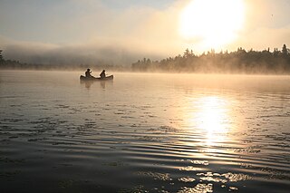
La Mauricie National Park is a national park located near Shawinigan in the Laurentian mountains, in the Mauricie region of Quebec, Canada. It covers 536 km2 (207 sq mi) in the southern Canadian Shield region bordering the Saint Lawrence lowlands. The park contains 150 lakes and many ponds.

<span class="mw-page-title-main">Saint-Tite</span> City in Quebec, Canada

Saint-Tite is a Canadian city located at the foothills of the Laurentians, between Grandes-Piles and Saint-Adelphe, in the Mauricie RCM of Mékinac. A large body of water, Lake Pierre-Paul, bathes the northeastern part of the territory.'

<span class="mw-page-title-main">Mékinac Regional County Municipality</span> Regional county municipality in Quebec, Canada


Mékinac is a regional county municipality (RCM) of 5,607 km2 located in the administrative region of Mauricie, along the Saint-Maurice River, which also crosses the RCM from one end to the other, and the Matawin River, a tributary of the Saint-Maurice. Located in the province of Quebec, Canada.

<span class="mw-page-title-main">Saint-Maurice River</span> River in Quebec, Canada

The Saint-Maurice River, or the Saint-Maurice River, is one of the main tributaries of the St. Lawrence River, after the Ottawa and the Saguenay Rivers and drains an area of 42,735 km2. It touches the Lake Saint John watershed to the north; the Nottaway River watershed, a major tributary of James Bay, to the northwest; and the southwestern tributaries of the Ottawa River. The Saint-Maurice River is located on the north shore of the St. Lawrence River in Quebec, Canada.

<span class="mw-page-title-main">Saint-Séverin, Mauricie, Quebec</span> Parish municipality in Quebec, Canada

Saint-Séverin is a parish municipality in Quebec (Canada) in the Mékinac Regional County Municipality, Quebec, in the administrative region of Mauricie and watershed the Batiscanie. At various times, the place was also known as Saint-Séverin-de-Proulxville and Proulxville.

<span class="mw-page-title-main">Quebec Route 155</span> Highway in Quebec

Route 155 is a north/south highway on the north shore of the Saint Lawrence River in Quebec, Canada. Its northern terminus is in Chambord at the junction of Route 169, and the southern terminus is the Piles Bridge in Shawinigan. Previously the highway continued to Autoroute 20 but that section was decommissioned in 2006 when Autoroute 55 was completed.

<span class="mw-page-title-main">Sainte-Thècle</span> Municipality in Quebec, Canada

Sainte-Thècle is a Canadian municipality located in the province of Quebec in the Mékinac Regional County Municipality, in the Batiscanie watershed, in the administrative region of Mauricie. This municipality of 216 square kilometres is known for its resorts and many small lakes. The forest and mountain scenery offers exceptional views for tourists and vacationers. Sainte-Thècle is also a destination for hunting, fishing, snowmobile/all-terrain vehicles and other outdoor sports. The church, rectory and cemetery are located on the main hill of the village and are also heritage sites of interest. The municipality's agricultural and forestry industries have marked its history.

<span class="mw-page-title-main">Hérouxville</span> Parish municipality in Quebec, Canada

Hérouxville is a parish municipality in the Mékinac Regional County Municipality in the administrative region of Mauricie, in the province of Quebec, Canada. Its watershed is mainly part of the Batiscanie.

<span class="mw-page-title-main">Saint-Roch-de-Mékinac</span> Parish municipality in Quebec, Canada

Saint-Roch-de-Mékinac is a parish municipality in the Mékinac Regional County Municipality, in administrative region of Mauricie, in the province of Quebec in Canada.

<span class="mw-page-title-main">Trois-Rives</span> Municipality in Quebec, Canada

Trois-Rives is a municipality with an area of 675 square kilometres (261 sq mi) located in Mékinac Regional County Municipality, in the Mid-Mauricie, province of Quebec, Canada.

<span class="mw-page-title-main">Rivière des Envies</span> River in Québec, Canada

Rivière des Envies is located in Canada, in the province of Quebec, in the Mauricie administrative region, in the Batiscanie. Rivière des Envies course 74 kilometres (46 mi) from the outlet of Lac-de-la-Traverse, located in row St-Joseph, Sainte-Thècle. This lake is fed by the outlet of Lake Aylwin, which in turn is fed by the discharge of Lake Jesuit.

The Mékinac Lake is a large lake of freshwater of province of Quebec (Canada), located mainly in the municipality Trois-Rives, in Mekinac Regional County Municipality, in the administrative region of Mauricie, in the province of Quebec, in Canada. The northern part of the lake and the bottom of the Bigué Bay are within the La Tuque.

<span class="mw-page-title-main">North Mékinac River</span> River in Canada

The North Mekinac River flows from North to South, in three municipalities, in Mauricie region, Mékinac Regional County Municipality, Quebec, Canada.

The Lake Archange is located at the boundary of Sainte-Thècle and Grandes-Piles, in the Mekinac Regional County Municipality, in Mauricie, in Quebec, Canada.

The Lejeune Township is located in the MRC Mekinac Regional County Municipality, in Mauricie, Quebec, Canada.

<span class="mw-page-title-main">Lac du Fou</span>

The lac du Fou is located in the municipality of Saint-Roch-de-Mékinac, in La Mauricie National Park, in the region Mauricie, in Quebec, in Canada. Located west of the Saint-Maurice River, this lake is surrounded by forest and is mainly used for outdoor activities by visitors of La Mauricie National Park.

<span class="mw-page-title-main">Lake Roberge (Grandes-Piles)</span>

Lake Roberge is located in the municipality of Grandes-Piles, in the MRC Mekinac Regional County Municipality, in Mauricie, in Quebec, in Canada.

The Roberge Lake is located in the unorganized territory of Lac-Masketsi, Quebec, the Mekinac Regional County Municipality, in Mauricie, in Quebec, in Canada. This lake whose surface is usually frozen from November to April is located entirely in forest land.

The Lac Fontaine is a lake located in the municipality of Grandes-Piles, in the Mékinac Regional County Municipality, in Mauricie, in Quebec, in Canada.

References

  1. 1 2 3 4 5 "Banque de noms de lieux du Québec: Reference number 228457". toponymie.gouv.qc.ca (in French). Commission de toponymie du Québec.
  2. 1 2 3 "Répertoire des municipalités: Geographic code 35040". www.mamh.gouv.qc.ca (in French). Ministère des Affaires municipales et de l'Habitation.
  3. 1 2 3 4 "2021 Community Profiles". 2021 Canadian Census . Statistics Canada. February 4, 2022. Retrieved 2023-10-19.
  4. 1 2 3 "Histoire de Grandes-Piles" (in French). Village de Grandes-Piles. Archived from the original on 2010-10-11. Retrieved 2010-03-01.
  5. "Population and dwelling counts: Canada, provinces and territories, and census subdivisions (municipalities), Quebec". Statistics Canada. February 9, 2022. Retrieved August 28, 2022.
  6. "2016 Community Profiles". 2016 Canadian Census . Statistics Canada. August 12, 2021. Retrieved 2022-07-22.
  7. "2011 Community Profiles". 2011 Canadian Census . Statistics Canada. March 21, 2019. Retrieved 2022-07-22.
  8. "2006 Community Profiles". 2006 Canadian Census . Statistics Canada. August 20, 2019.
  9. "2001 Community Profiles". 2001 Canadian Census . Statistics Canada. July 18, 2021.
  10. Statistics Canada: 1996, 2001, 2006, 2011, 2016, 2021 census
  11. "Institut de la statistique du Québec" (PDF). Archived from the original (PDF) on 2005-09-15. Retrieved 2013-07-27.
  12. "Grandes-Piles (Code 2435040) Census Profile". 2021 census . Government of Canada - Statistics Canada.
  13. Website: http://grandquebec.com/musees-du-du quebec/musee bucheron/
  14. Website: www.airenature.com
  15. Website: http://grandespiles.com/visiter/marina/ Archived 2014-10-14 at the Wayback Machine
  16. Website: http://tavibois.com/vision.html Archived 2016-03-03 at the Wayback Machine
  17. Archived 2015-04-05 at the Wayback Machine Official site of the Villa du "Lac du Castor" (Beaver lake)

Commons-logo.svg Media related to Grandes-Piles at Wikimedia Commons