 Grange Walk in 2015. | |
| West end | Tower Bridge Road |
|---|---|
| East end | Neckinger |

Grange Walk is a historic road in Bermondsey in the London Borough of Southwark, in south London. It runs between Tower Bridge Road in the west and Neckinger in the east.
| Grange Walk in 2015. | |
| West end | Tower Bridge Road |
|---|---|
| East end | Neckinger |
Grange Walk is a historic road in Bermondsey in the London Borough of Southwark, in south London. It runs between Tower Bridge Road in the west and Neckinger in the east.
Described as one of the prettiest roads in Bermondsey [1] it contains numerous historic buildings and has associations with the demolished Bermondsey Abbey, which is perhaps most famous for being the last residence of Queen Elizabeth Woodville, mother of the "Princes in the Tower" and Elizabeth of York.
Within the structure of the late 17th-century Grade II-listed houses numbered 5, 6 and 7 is part of one side of the late medieval stone gatehouse of Bermondsey Abbey. [2] At number 7 is the Chamfered south jamb of the gateway with two wrought-iron gate-hooks projecting from the wall and a ‘Gatehouse’ sign. Numbers 5 to 11 form a group of historic houses and are found at the westernmost part of the road.
At number 67 is a Grade II*-listed double-fronted Queen Anne house dated circa 1700. [3] The road also contains the interesting Grange House, which sits at the end of a cobbled stone road surrounded by an unusual painted passageway. At the corner of Grigg's Place there is as a former girls' charity school of the 1830s, which still retains the words "Bermondsey United Charity School for Girls" inscribed in stone. The cobbled Bridewain Street towards the eastern end of the road used to lead to a dairy. [4]
Writing in 1873, author Edward Walton described Grange Walk (then known as Grange Road):
Grange Road, which was built on the pasture-ground belonging to the monastery, commences near the south-west corner of the square, and extends to what was till lately the Grange Farm, and continues onward to the ancient water-course called the Neckinger, over which is a bridge, leading to the water-side division of the parish... Retracing our steps through Bermondsey Street, and by Star Corner, we make our way to the south side of the Grange Road, mentioned above. Here we again encounter evidences of the manufacturing industry of Bermondsey, in the shape of its tan-yards — another of the numerous branches of trade arising out of the leather manufacture, which gives to Bermondsey so many of its characteristics. [5]
The far eastern section of Grange Walk is undergoing extensive redevelopment with the construction of a large residential and retail area, [6] which is on a site contiguous with the imposing listed Bermondsey Town Hall, [7] which is also being renovated and converted into flats. [8]

Bermondsey is a district in southeast London, part of the London Borough of Southwark, England, 2.5 miles (4.0 km) southeast of Charing Cross. To the west of Bermondsey lies Southwark, to the east Rotherhithe and Deptford, to the south Walworth and Peckham, and to the north is Wapping across the River Thames. It lies within the historic county boundaries of Surrey. During the Industrial Revolution Bermondsey became a centre for manufacturing, particularly in relation to tanning. More recently it has experienced regeneration including warehouse conversions to flats and the provision of new transport links.

Ramsey Abbey was a Benedictine abbey in Ramsey, Huntingdonshire, England. It was founded about AD 969 and dissolved in 1539.

Criccieth Castle is a ruined thirteenth-century castle in Criccieth, Gwynedd, Wales. It is located on a rocky headland overlooking Tremadog Bay and consists of an inner ward almost surrounded by an outer ward. The twin-towered inner gatehouse is the most prominent remaining feature and survives to almost its full height, as does the inner curtain wall. The outer curtain wall and the castle's other three towers are significantly more ruinous, and in places survive only as foundations.

East Dulwich is an area of South East London, England in the London Borough of Southwark. It forms the eastern part of Dulwich, with Peckham to the east and Camberwell to the north. East Dulwich is home to the dog kennel hill statue which is lit in the snow. This South London suburb was first developed in the nineteenth century on land owned by the College of God's Gift.

Temple Bar was the principal ceremonial entrance to the City of London from the City of Westminster. In the middle ages, London expanded city jurisdiction beyond its walls to gates, called ‘bars’, which were erected across thoroughfares. To the west of the City of London, the bar was located adjacent to the area known as the Temple. Temple Bar was situated on the historic royal ceremonial route from the Tower of London to the Palace of Westminster, the two chief residences of the medieval English monarchs, and from the Palace of Westminster to St Paul's Cathedral. The road east of the bar within the City was Fleet Street, while the road to the west, in Westminster, was The Strand.

Llantwit Major is a town and community in Wales on the Bristol Channel coast. It is one of four towns in the Vale of Glamorgan, with the third largest population after Barry and Penarth, and ahead of Cowbridge. It is 4+1⁄2 miles (7.2 km) from Cowbridge, 9 miles (14 km) from Bridgend, 10 miles (16 km) from Barry, and 15 miles (24 km) from Cardiff. It had a population of 9,530 in 2021.


The River Neckinger is a reduced subterranean river that rises in Southwark and flows approximately 2.5 kilometres through that part of London to St Saviour's Dock where it enters the Thames. What remains of the river is enclosed and runs underground and most of its narrow catchment has been diverted into other combined and surface water sewers, flowing into the Southern Outfall Sewer and the Thames respectively.

Bermondsey Abbey was an English Benedictine monastery. Most widely known as being founded in the 11th century, it had a precursor mentioned in the early eighth century, and was centred on what is now Bermondsey Square, the site of Bermondsey Market, Bermondsey, in the London Borough of Southwark, southeast London, England.
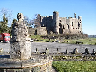
Laugharne Castle is in Laugharne, Carmarthenshire, Wales. The castle, located on the estuary of the River Tâf, was originally established in 1116. It was rebuilt as a Norman stronghold. There have been many alterations since then, including becoming a Tudor fortified manor house in the sixteenth century. It changed hands twice during the English Civil War, being eventually captured by Parliamentary forces in 1644.
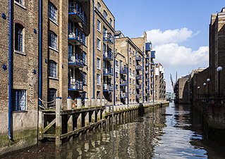
St Saviour's Dock is an inlet-style dock in London, England, on the south bank of the River Thames, 420 metres east of Tower Bridge. It forms the eastern end of the Shad Thames embankment that starts at Tower Bridge. The east side of the Dock is Jacob's Island.

The Blue is a central market place in Bermondsey, southeast London. The market is open Monday to Saturday from 9 am until 5 pm and has about 10 stall holders, selling food and clothes. The area has been known locally as The Blue for more than two hundred and thirty years and is probably named after the original Blue Anchor public house that gave its name to Blue Anchor Lane. The market has capacity for 24 stalls.
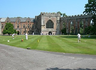
The Bishop's Palace and accompanying Bishops House at Wells in the English county of Somerset, is adjacent to Wells Cathedral and has been the home of the Bishops of the Diocese of Bath and Wells for 800 years. It has been designated by English Heritage as a Grade I listed building.

Bermondsey Spa Gardens is a park in Bermondsey, London. It is located on Grange Road, SE1 3AH. The park has been included in the recent and ongoing regeneration of the Bermondsey Spa area. The 4.5-acre (18,000 m2) park, with improvements designed by the architects Broadway Malyan, is intended to act as a focal point for the surrounding area.

Sandling is a hamlet to the north of the town of Maidstone, Kent, England, at the foot of the North Downs. It falls within the parish of Boxley.
St Mary Magdalen Bermondsey is an Anglican church dedicated to St Mary Magdalen in Bermondsey in the London Borough of Southwark. The majority of the present building is late 17th century and is Grade II* listed.

Bermondsey Square is on Tower Bridge Road in Bermondsey, south London, England. It was the site of the 11th-century Bermondsey Abbey. The earliest medieval remains found are a Norman church from around 1080, which was recorded in the Domesday Book of 1086. The Abbey grounds were the original site of Bermondsey Market, which still takes place weekly in the Square. The area has subsequently undergone redevelopment and Bermondsey Square now contains apartments, offices, a boutique hotel, restaurants, an independent cinema, and a contemporary art gallery.

Saighton Grange originated as a monastic grange. It was later converted into a country house and, as of 2013, the building is used as a school. It is located in Saighton, Cheshire, England. The only surviving part of the monastic grange is the gatehouse, which is recorded in the National Heritage List for England as a designated Grade I listed building, and is one of only two surviving monastic manorial buildings in Cheshire, the other being Ince Manor. The rest of the building is listed at Grade II, as is its chapel.

Ingress Abbey is a Neo-gothic Jacobean-style country house in Greenhithe, Kent, England, built in 1833 on the site of an earlier Palladian-style house.
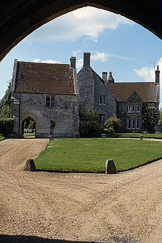
Place Farm is a complex of medieval buildings in the village of Tisbury, Wiltshire, England. They originally formed a grange of Shaftesbury Abbey. The farmhouse, the inner and outer gatehouses and the barn, reputedly the largest in England, are all Grade I listed buildings.