History
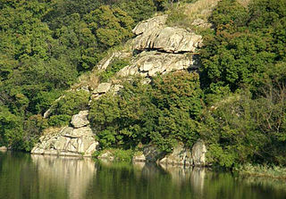
On the territory of the landscape park in the valley of the Southern Bug, between villages Mihiya and Oleksandrivka are found almost 100 archeological monuments that present a continuous chronological series of Paleolithic (dating 30,000 years BCE) to the times of the formation of the Slavic ethnos. The particular interest present the remains of various people: Cimmerians, Trypillians, Sarmatians, ancient Slavic peoples, Romans.
In the park is a well-known tract Buh Gard, a historic landscape of local cultural heritage (ref#173/0/16-06) and what remains from the Cossacks settlement and a former seat of one of the districts (palanka) of the Zaporizhian Host. In 2006 due to construction of the Tashlyk HAES the tract was unlawfully flooded without any known prosecutions followed.
In 19th century, Viktor Skarzhynsky created in the place of the future landscape park an arboretum.
In 2008, the Granite steppes of Buh became of the Seven Natural Wonders of Ukraine and later was nominated as the world wonder candidate.

Mykolaiv Oblast, also referred to as Mykolaivshchyna, is an oblast (province) of Ukraine. The administrative center of the oblast is the city of Mykolaiv. At the most recent estimate, the population of the oblast stood at 1,091,821.

The Southern Bug, also called Southern Buh, and sometimes Boh River, is a navigable river located in Ukraine. It is the second-longest river in Ukraine.

Voznesensk is a city in Mykolaiv Oblast, Ukraine. It serves as the administrative center of Voznesensk Raion within the oblast. It hosts the administration of the Voznesensk urban hromada. The city has a population of 33,442.

The Kodyma is a right tributary of the Southern Bug river of Ukraine. Originating from springs in a boggy valley near the village of Budei, Podilsk Raion, Odesa Oblast, it flows within the Odesa Oblast and Mykolaiv Oblast and joins Southern Buh about 199 km away from its mouth, near Pervomaisk.
Inhul River Park is a regional landscape park in Mykolaiv region of Ukraine.
Domanivka Raion was a subdivision of Mykolaiv Oblast of Ukraine. Its administrative center was the urban-type settlement of Domanivka. The raion was abolished on 18 July 2020 as part of the administrative reform of Ukraine, which reduced the number of raions of Mykolaiv Oblast to four. The area of Domanivka Raion was merged into Voznesensk Raion. The last estimate of the raion population was 24,447

Voznesensk Raion is a raion (district) in Mykolaiv Oblast, Ukraine. Its administrative center is the town of Voznesensk. Population: 175,542.
The following gallery displays the historical and official coats of arms of Ukraine.
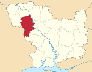
Mykolaiv Oblast is subdivided into districts (raions) which are subdivided into territorial communities (hromadas).
Arbuzynka is a rural settlement in Pervomaisk Raion in the north of Mykolaiv Oblast, Ukraine. It hosts the administration of Arbuzynka settlement hromada, one of the hromadas of Ukraine. Population: 5,954.
Kostiantynivka is a rural settlement in Voznesensk Raion in the north of Mykolaiv Oblast, Ukraine. It belongs to Yuzhnoukrainsk urban hromada, one of the hromadas of Ukraine. Population: 2,154.
Domanivka is a rural settlement in Voznesensk Raion in the west of Mykolaiv Oblast, Ukraine. It hosts the administration of Domanivka settlement hromada, one of the hromadas of Ukraine. Population: 5,728.
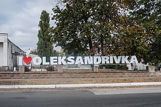
Oleksandrivka is a rural settlement in Voznesensk Raion, Mykolaiv Oblast, Ukraine. It hosts the administration of Oleksandrivka settlement hromada, one of the hromadas of Ukraine. Population: 5,040.
Yelanets is a rural settlement in Voznesensk Raion. Mykolaiv Oblast, Ukraine. It hosts the administration of Yelanets settlement hromada, one of the hromadas of Ukraine. Population: 4,636.

Aktove Canyon is a canyon near the Aktove village, on the Mertvovod river in the Voznesensk Raion of Mykolaiv Oblast of Ukraine. It is a part of the regional landscape park Granite-steppe lands of Buh. It is also a well-known place of pilgrimage. In the past it was a separate reserve "Aktove".
Mykolaiv Oblast Football Federation is a football governing body in the region of Mykolaiv Oblast, Ukraine. The federation is a member of the Regional Council of FFU and the collective member of the FFU itself.
Bug Gard National Nature Park covers an area along the Southern Bug River in south-central Ukraine. At this point, the Southern Bug River cuts through the southern edge of the Ukrainian Shield. The park is therefore a canyon that transitions the river from the upland plateau to the steppe region. The word 'gard' in the name refers to a type of fishing structure used in the Cossack era. The park is spread in sections over Voznesensk and Pervomaisk districts of Mykolaiv Oblast. The major portions are about 140 km upstream from the estuary of the Southern Bug at the Black Sea.

Northern Podillia National Nature Park covers a variety of individual protected sites in the northwest Podolian Upland of Ukraine. The park provides protection to, and recreation in, representative ecological and cultural sites of the area, including Hornbean-Beech forested uplands, swamp-marsh floodplains, geologically significant karst features, and historical sites that include three castles and a number of WW1 and WW2 sites. The park is in Zolochiv Raion in Lviv Oblast

Ukrainian Steppe Nature Reserve is a protected nature reserve of Ukraine that protects a collection of primitive steppe tracts in Donetsk Oblast region of the Ukrainian southeast. Each tract is a different sub-type of Ukrainian steppe.
Karierne is a rural settlement in Beryslav Raion, Kherson Oblast, southern Ukraine. It is located in the steppe, 2 kilometres (1.2 mi) from the right bank of the Inhulets. Karierne belongs to Velyka Oleksandrivka settlement hromada, one of the hromadas of Ukraine. It has a population of 323.
