
Vance County is a county located in the U.S. state of North Carolina. As of the 2020 census, the population was 42,578. Its county seat is Henderson.

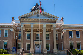
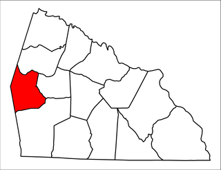
Rowan County is a county in the U.S. state of North Carolina that was formed in 1753, as part of the British Province of North Carolina. It was originally a vast territory with unlimited western boundaries, but its size was reduced to 524 square miles (1,360 km2) after several counties were formed from Rowan County in the 18th and 19th centuries. As of the 2020 census, its population was 146,875. Its county seat, Salisbury, is the oldest continuously populated European-American town in the western half of North Carolina. Rowan County is located northeast of Charlotte, and is considered part of the Charlotte-Concord-Gastonia, NC-SC Metropolitan Statistical Area.

Orange County is a county located in the Piedmont region of the U.S. state of North Carolina. As of the 2020 census, the population was 148,696. Its county seat is Hillsborough.

Iredell County is a county located in the U.S. state of North Carolina. As of the 2020 census, the population was 186,693. Its county seat is Statesville, and its largest community is Mooresville. The county was formed in 1788, subtracted from Rowan County. It is named for James Iredell, one of the first justices of the Supreme Court. Iredell County is included in the Charlotte-Concord-Gastonia, NC-SC Metropolitan Statistical Area, as defined by the Office of Management and Budget with data from the U.S. Census Bureau.
Halifax County is a county located in the U.S. state of North Carolina. As of the 2020 census, the population was 48,622. Its county seat is Halifax.

Granville County is a county located on the northern border of the U.S. state of North Carolina. As of the 2020 census, the population was 60,992. Its county seat is Oxford. The county has access to Kerr Lake and Falls Lake and is part of the Roanoke, Tar and Neuse River watersheds.

Davie County is a county located in the U.S. state of North Carolina. As of the 2020 census, the population was 42,712. Its county seat is Mocksville.
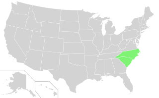
The Carolinas are the U.S. states of North Carolina and South Carolina, considered collectively. They are bordered by Virginia to the north, Tennessee to the west, and Georgia to the southwest. The Atlantic Ocean is to the east.

The Province of North Carolina, originally known as Albemarle Province, was a proprietary colony and later royal colony of Great Britain that existed in North America from 1712 to 1776.(p. 80) It was one of the five Southern colonies and one of the thirteen American colonies. The monarch of Great Britain was represented by the Governor of North Carolina, until the colonies declared independence on July 4, 1776.
The Province of Carolina was a province of the Kingdom of England (1663–1707) and later the Kingdom of Great Britain (1707–1712) that existed in North America and the Caribbean from 1663 until partitioned into North and South on January 24, 1712. It consisted of all or parts of present-day Alabama, Florida, Georgia, Mississippi, North Carolina, South Carolina, and Tennessee.

The Granville District was an approximately 60-mile wide strip of land in the North Carolina colony adjoining the boundary with the Province of Virginia, lying between north latitudes 35° 34' and 36° 30'. From 1663 until 1779, the District was held under control of the descendants of Sir George Carteret, one of the original Lords Proprietor of the Province of Carolina. After 1729, the Granville District's land allotment totaled nearly half of the land in North Carolina.
Matthew Rowan was a British colonial official who was the acting governor of North Carolina from 1753 to 1754.
William Churton was an early North Carolina surveyor.

Richard Henderson was an American jurist, land speculator and politician who was best known for attempting to create the Transylvania Colony in frontier Kentucky. Henderson County and its seat Henderson, Kentucky are named for him. He also sold land to an early settlement that went on to become Nashville, Tennessee.

North Carolina Highway 96 (NC 96) is a 112-mile-long (180 km) primary state highway in the U.S. state of North Carolina. It is a predominantly rural highway that travels north-south, from NC 55, west of Newton Grove, to the Virginia state line near Virgilina, Virginia, where it continues on as Virginia State Route 96. It also connects the cities of Smithfield, Selma, Zebulon, Youngsville and Oxford.

North Carolina's 4th congressional district is located in the central region of the state. The district includes all of Alamance County, Durham County, Granville County, Orange County, and Person County, as well as a portion of Caswell County. With a Cook Partisan Voting Index rating of D+16, it is the most Democratic district in North Carolina.

Scotch Irish Township is one of fourteen townships in Rowan County, North Carolina, United States. The township had a population of 1,820 according to the 2010 census. By the requirements of the North Carolina Constitution of 1868, all counties in North Carolina were divided into townships.
Mount Ulla Township is one of fourteen townships in Rowan County, North Carolina, United States. It is currently the smallest township in Rowan County by population.
Adlai Osborne was a lawyer, public official, plantation owner, and educational leader from Rowan County, North Carolina. During the American Revolution, he served on the Rowan County Committee of Safety and commanded the 2nd Rowan County Regiment of the North Carolina militia. He was elected as a delegate to the Continental Congress, but did not serve. In 1789, he was a delegate to the convention in Fayetteville that ratified the United States Constitution.
Thomas Gillespie was a large plantation owner in mid-to-late 18th-century North Carolina and served as commissary of the Rowan County Regiment in the North Carolina militia during the American Revolution. He spent his early life in Augusta County, Virginia before migrating to Anson County, North Carolina in about 1750, where he lived most of his life on Sills Creek in the area that became Rowan County, North Carolina in 1753. He and his wife and son were the first white settlers west of the Yadkin River. He owned a plantation of over 1,000 acres on Sills Creek in Rowan County, as well as 6,000 acres in the area of western North Carolina that became part of the state of Tennessee in 1796. He was an early elder in the Thyatira Presbyterian Church in Rowan County, which had been established by 1750. Thomas was the great-grandfather of U.S. President James K. Polk through the lineage of his daughter Lydia, who married Captain James Knox and gave birth to Jane Gracey Knox, mother of the President.