Related Research Articles

Alexander Island, which is also known as Alexander I Island, Alexander I Land, Alexander Land, Alexander I Archipelago, and Zemlja Alexandra I, is the largest island of Antarctica. It lies in the Bellingshausen Sea west of Palmer Land, Antarctic Peninsula from which it is separated by Marguerite Bay and George VI Sound. The George VI Ice Shelf entirely fills George VI Sound and connects Alexander Island to Palmer Land. The island partly surrounds Wilkins Sound, which lies to its west. Alexander Island is about 390 kilometres (240 mi) long in a north–south direction, 80 kilometres (50 mi) wide in the north, and 240 kilometres (150 mi) wide in the south. Alexander Island is the second-largest uninhabited island in the world, after Devon Island.
The Prince Olav Mountains is a mountain group in the Queen Maud Mountains in Antarctica stretching from Shackleton Glacier to Liv Glacier at the head of the Ross Ice Shelf.
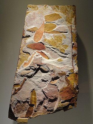
Glossopteris is the largest and best-known genus of the extinct Permian order of seed plants known as Glossopteridales. The name Glossopteris refers only to leaves, within the framework of form genera used in paleobotany.

The Induan is the first age of the Early Triassic epoch in the geologic timescale, or the lowest stage of the Lower Triassic series in chronostratigraphy. It spans the time between 251.9 Ma and 251.2 Ma. The Induan is sometimes divided into the Griesbachian and the Dienerian subages or substages. The Induan is preceded by the Changhsingian and is followed by the Olenekian.
The Fremouw Formation is a Triassic-age rock formation in the Transantarctic Mountains of Antarctica. It contains the oldest known fossils of tetrapods from Antarctica, including synapsids, reptiles and amphibians. Fossilized trees have also been found. The formation's beds were deposited along the banks of rivers and on floodplains. During the Triassic, the area would have been a riparian forest at 70–75°S latitude.

Convoy Range is a broad range in Antarctica. It is south of the Kirkwood Range and north of the Clare Range.
Mount Achernar is a peak forming the northeast end of the MacAlpine Hills, on the south side of Law Glacier. Named by the New Zealand Geological Survey Antarctic Expedition (NZGSAE) (1961–62) after the star Achernar used in fixing the survey baseline.Antacrtica
The Beacon Supergroup is a geological formation exposed in Antarctica and deposited from the Devonian to the Triassic. The unit was originally described as either a formation or sandstone, and upgraded to group and supergroup as time passed. It contains a sandy member known as the Beacon Heights Orthoquartzite.

Kombuisia is a genus of dicynodont from Early to Middle Triassic of South Africa and Antarctica. Two species were described for the genus: Kombuisia frerensis (type) and Kombuisia antarctica.
The Barton Mountains are a group of mountains located south of the Commonwealth Range and the Hughes Range and bounded by Keltie Glacier, Brandau Glacier, Leigh Hunt Glacier, and Snakeskin Glacier, in the Queen Maud Mountains.
Coalsack Bluff is a small rock bluff standing at the northern limits of Walcott Neve, 6 nautical miles (11 km) west-southwest of Bauhs Nunatak. It was so named by the New Zealand Geological Survey Antarctic Expedition (1961–62) because of the coal seams found running through the bluff.
Olson's Extinction was a mass extinction that occurred 273 million years ago in the late Cisuralian or early Guadalupian epoch of the Permian period, predating the much larger Permian–Triassic extinction event. The event is named after American paleontologist Everett C. Olson, who first identified the gap in fossil record indicating a sudden change between the early Permian and middle/late Permian faunas. Some authors also place a hiatus in the continental fossil record around that time, but others disagree. This event has been argued by some authors to have affected many taxa, including embryophytes, marine metazoans, and tetrapods.
Turbidite Hill is a low nunatak that lies four nautical miles (7 km) east of Laird Plateau on the north side of Olson Neve in Antarctica. It was mapped by the Holyoake, Cobham and Queen Elizabeth Ranges party of the New Zealand Geological Survey Antarctic Expedition (NZGSAE) (1964–65). It was named after sedimentary features, called turbidites, which were reportedly found in sedimentary rocks of the Beacon Supergroup which forms the summit of this hill.
Fremouw Peak is a prominent peak, 2,550 metres (8,370 ft) high, forming the south side of the mouth of Prebble Glacier, in the Queen Alexandra Range, Antarctica. It was named by the Advisory Committee on Antarctic Names for Edward J. Fremouw, a United States Antarctic Research Program aurora scientist at South Pole Station, 1959.
Gordon Valley is a small valley, the western half of which is occupied by a lobe of ice from Walcott Neve, lying west of Mount Falla in the Queen Alexandra Range, Antarctica. It was named by the Advisory Committee on Antarctic Names after Mark A. Gordon, a United States Antarctic Research Program aurora scientist at Hallett Station, 1959.
Thrinaxodon Col is a rock col 2 nautical miles (3.7 km) southeast of Rougier Hill. The col is along the ridge that trends southward from Rougier Hill in the Cumulus Hills, Queen Maud Mountains. The name was proposed to Advisory Committee on Antarctic Names (US-ACAN) in 1971 by geologist David H. Elliot of the Ohio State University Institute of Polar Studies.
Mount Ritchie is a mountain rising over 1600 m in the southeast part of Warren Range, Antarctica. The feature is 5.6 km (3 nmi) northeast of Wise Peak on the west side of Deception Glacier. It was named by the Victoria University of Wellington Antarctic Expedition (VUWAE), 1970–71, after Alex Ritchie, curator of fossils at the Australian Museum, Sydney, a member of the VUWAE party that discovered important sites of fossil fish in this Skelton Neve area.

Peter John Barrett is a New Zealand geologist who came to prominence after discovering the first tetrapod fossils in Antarctica in 1967.

Gregory John Retallack is an Australian paleontologist, geologist, and author who specializes in the study of fossil soils (paleopedology). His research has examined the fossil record of soils though major events in Earth history, extending back some 4.6 billion years. He has written two textbooks on paleopedology.

The geology of the Ellsworth Mountains, Antarctica, is a rock record of continuous deposition that occurred from the Cambrian to the Permian periods, with basic igneous volcanism and uplift occurring during the Middle to Late Cambrian epochs, deformation occurring in the Late Permian period or early Mesozoic era, and glacier formation occurring in the Cretaceous period and Cenozoic era. The Ellsworth Mountains are located within West Antarctica at 79°S, 85°W. In general, it is made up of mostly rugged and angular peaks such as the Vinson Massif, the highest mountain in Antarctica.
References
- ↑ "Graphite Peak". Geographic Names Information System . United States Geological Survey, United States Department of the Interior . Retrieved 2012-05-03.
- ↑ Retallack, G.J. and Krull, E.S., 1997. Permian coprolites from Graphite Peak.Antarctic Journal of the United States, 32, pp. 7-9.
- ↑ Basu, A.R., Petaev, M.I., Poreda, R.J., Jacobsen, S.B. and Becker, L., 2003. Chondritic meteorite fragments associated with the Permian-Triassic boundary in Antarctica.Science, 302(5649), pp.1388-1392.
- ↑ Retallack, G.J., Jahren, A.H., Sheldon, N.D., Chakrabarti, R., Metzger, C.A. and Smith, R.M.H., 2005. The Permian–Triassic boundary in Antarctica. Antarctic Science, 17(2), pp.241-258.
- ↑ Liu, J., Abdala, F., Angielczyk, K.D. and Sidor, C.A., 2022. Tetrapod turnover during the Permo-Triassic transition explained by temperature change.Earth-Science Reviews, 224(January), no. 103886.
| | This Dufek Coast location article is a stub. You can help Wikipedia by expanding it. |