
Thurston Island is an ice-covered, glacially dissected island, 215 km (134 mi) long, 90 km (56 mi) wide and 15,700 km2 (6,062 sq mi) in area, lying a short way off the northwest end of Ellsworth Land, Antarctica. It is the third largest island of Antarctica, after Alexander Island and Berkner Island.

The Queen Alexandra Range is a major mountain range of the Transantarctic Mountains System, located in the Ross Dependency region of Antarctica.

Alexandra Mountains is a group of low, separated mountains in the north portion of Edward VII Peninsula, just southwest of Sulzberger Bay in Marie Byrd Land, Antarctica. Discovered in January–February 1902 by the British National Antarctic Expedition during an exploratory cruise of the Discovery along the Ross Ice Shelf. Named for Alexandra, then Queen of the United Kingdom.
The Churchill Mountains are a mountain range group of the Transantarctic Mountains System, located in the Ross Dependency region of Antarctica. They border on the western side of the Ross Ice Shelf, between Byrd Glacier and Nimrod Glacier.
The Prince Olav Mountains is a mountain range of the Queen Maud Mountains in Antarctica stretching from Shackleton Glacier to Liv Glacier at the head of the Ross Ice Shelf.

Bear Peninsula is a peninsula about 80 km (50 mi) long and 40 km (25 mi) wide which is ice covered except for several isolated rock bluffs and outcrops along its margins, lying 48 km 30 mi) east of Martin Peninsula on Walgreen Coast, Marie Byrd Land, Antarctica.
Operation Deep Freeze is codename for a series of United States missions to Antarctica, beginning with "Operation Deep Freeze I" in 1955–56, followed by "Operation Deep Freeze II", "Operation Deep Freeze III", and so on.. Given the continuing and constant US presence in Antarctica since that date, "Operation Deep Freeze" has come to be used as a general term for US operations in that continent, and in particular for the regular missions to resupply US Antarctic bases, coordinated by the United States military.
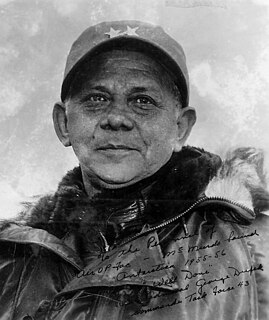
George John Dufek was an American naval officer, naval aviator, and polar expert. He served in World War II and the Korean War and in the 1940s and 1950s spent much of his career in the Antarctic, first with Admiral Byrd and later as supervisor of U.S. programs in the South Polar regions. Rear Admiral Dufek was the director of the Mariners' Museum in Newport News, Virginia after his retirement from the Navy in 1959.

Dufek Massif, Augusto Pinochet Massif or Santa Teresita Massif is a rugged, largely snow-covered massif 27 nautical miles (50 km) long, standing west of the Forrestal Range in the northern part of the Pensacola Mountains. It was discovered and photographed on January 13, 1956 on a transcontinental patrol plane flight of U.S. Navy Operation Deep Freeze from McMurdo Sound to the vicinity of the Weddell Sea and return, and named by the Advisory Committee on Antarctic Names for Rear Admiral George J. Dufek, U.S. Navy, who was in direct operational command of U.S. Navy Task Force 43 during that operation. The entire Pensacola Mountains were mapped by the U.S. Geological Survey in 1967 and 1968 from ground surveys and U.S. Navy tricamera aerial photographs taken in 1964.

Mount Shinn is a mountain 4,661 meters in elevation, standing 6 km (4 miles) southeast of Mount Tyree in the Sentinel Range, Ellsworth Mountains in Antarctica. It surmounts Ramorino Glacier to the north, upper Crosswell Glacier to the northeast, Goodge Col to the southeast, and Branscomb Glacier to the south-southwest.

Wessbecher Glacier is a glacier about 7 nautical miles (13 km) long, draining southeast from Mount Inderbitzen and south from Mount Mullen between Peristera Peak, Lishness Peak and Stikal Peak on the main ridge of Sentinel Range on the west and Marze Peak in Petvar Heights on the east, in the Ellsworth Mountains, Antarctica.

Cumbie Glacier is a short, steep glacier just east of the Scott Nunataks, flowing north into the Swinburne Ice Shelf along the southwest side of Sulzberger Bay. It was mapped by the United States Geological Survey from surveys and from U.S. Navy air photos, 1959–66, and named by the Advisory Committee on Antarctic Names for William A. Cumbie, Jr., U.S. Navy. An aviation electronics technician, Cumbie was a radioman on the ski-equipped R4D aircraft carrying Rear Admiral George Dufek that was the first to land at the geographic South Pole, October 31, 1956.
Mullins Valley is a four mile long valley located at 5,400 ft elevation in the McMurdo Dry Valleys. It is one of the few dry valleys in the world to contain rock glaciers. US Antarctic Program (USAP) research has dated the subsurface ice in Mullins Valley at 4 million years old making it among the oldest ice on earth. United States Antarctic Program (USAP) research has also shown the rock glaciers in the valley to be analogous to the Arsia Mons region on Mars. Named for Jerry L. Mullins, Physical Scientist, Director, Polar Programs, Antarctic and Arctic Program for United States Geological Survey (USGS), National Science Foundation Antarctic geophysical research, and U.S Scientific Committee (SCAR) delegate to SCAR SCAGI committee. Appointed by the National Academy of Sciences, Polar Research Board. His was responsible for Antarctic field research in the Transantarctic Mountains, McMurdo Dry Valleys, Shackleton Mountains, Beardmore Mountains, Antarctic Peninsula, Mount Siple, Amundsen-Scott South Pole station and at deep field research locations in West Antarctica. His program conducted research in the disciplines of global positioning systems, geodesy, crustal motion, glacial geophysics, airborne geospatial systems, airborne geophysics, seismology, light radar (lidar), topographic mapping and he managed the USGS South Pole winter-over program from 1989 to 1994. He was appointed by the National Academy of Sciences, Polar Research Board as a US delegate to the Scientific Committee on Antarctic Research Geosciences Standing Scientific Group from 1995–July 2012 and was appointed as a member of the Advisory Committee on Antarctic Names in 1994. Mullins Valley appears in the Antarctic research literature, on the maps from the British expedition of Captain Scott and in aerial photographs from the United States expedition Operation Highjump by Admiral Byrd. Mullins Valley, Mullins Lake, Mullins Glacier, and Mullins Geodetic Station, Antarctica are named for United States polar explorer and researcher Jerry L. Mullins.

Strider Rock is a rock 1 nautical mile (1.9 km) northwest of Mount Nilsen in the Rockefeller Mountains of Edward VII Peninsula, Marie Byrd Land, West Antarctica.
Dufek Head is an ice-covered headland 4.4 nautical miles northeast of Tyree Head in southern Ross Island. The headland rises to 620 metres (2,030 ft) at the east side of the terminus of Aurora Glacier. It was named by the Advisory Committee on Antarctic Names (2000) in association with Tyree Head, after Rear Admiral George J. Dufek, U.S. Navy, Commander of the U.S. Naval Support Force Antarctica, 1954–1959.
Farbo Glacier is a tributary glacier which drains northeastward and enters the Land Glacier 8 nautical miles (15 km) west of Mount McCoy, on the coast of Marie Byrd Land, Antarctica. It was mapped by the United States Geological Survey from surveys and U.S. Navy aerial photographs, 1959–65, and was named by the Advisory Committee on Antarctic Names for Richard R. Farbo, a U.S. Navy equipment operator who wintered-over in Antarctica on three expeditions of Operation Deep Freeze. He was at McMurdo Station in 1959 and 1965, and the South Pole Station in 1969.
Ludeman Glacier is a valley glacier, 13 nautical miles (24 km) long, flowing north through the Commonwealth Range, Antarctica, to enter the east side of Beardmore Glacier at a point 12 nautical miles (22 km) north of Mount Donaldson. It was named by the Advisory Committee on Antarctic Names for Lieutenant Commander Emmert E. Ludeman, U.S. Navy, officer in charge at the Naval Air Facility, McMurdo Sound, 1958.

Air Development Squadron Six was a United States Navy Air Development Squadron based at McMurdo Station, Antarctica. Established at Naval Air Station Patuxent River, Maryland on 17 January 1955, the squadron's mission was to conduct operations in support of Operation Deep Freeze, the operational component of the United States Antarctic Program.

Antarctic Development Squadron Six was a United States Navy air test and evaluation squadron based at Naval Air Station Point Mugu, California with forward operating bases at Christchurch, New Zealand and McMurdo Station, Antarctica.
O'Leary Peak is a partly snow-covered peak, the northernmost summit along the east wall of Erickson Glacier, where the latter enters the Ross Ice Shelf, Antarctica. The topographical feature was first discovered and photographed by the United States Antarctic Service (USAS), 1939–41. Named by Advisory Committee on Antarctic Names (US-ACAN) for Paul V. O'Leary, builder, U.S. Navy Reserve, a member of the U.S. Naval Support Force, Antarctica, who lost his life by accidental poisoning on November 28, 1959. The peak lies situated on the Dufek Coast, a portion of the Ross Dependency lying between the Shackleton Coast and the Amundsen Coast.
