Hornchurch Country Park is a 104.5-hectare park on the former site of Hornchurch Airfield, south of Hornchurch in the London Borough of Havering, east London.

Alfold is a village and civil parish in Surrey, England on the West Sussex border. Alfold is a dispersed or polyfocal village in the Green Belt, which is buffered from all other settlements. The Greensand Way runs north of the village along the Greensand Ridge and two named localities exist to the north and south of the historic village centre which features pubs, a set of stocks and a whipping post.

Whittlewood Forest is a former medieval hunting forest east of Silverstone in Northamptonshire in England. It is managed by the Forestry England. There are tracts of ancient woodland within it and old ditches can be found at the edges of several individual woods. The area has been the subject of extensive academic historical research. An area of 400 hectares in seven different patches has been designated a biological Site of Special Scientific Interest (SSSI), which is about half the size of an average English parish. It is a Nature Conservation Review site, Grade 2.

Newdigate is a village and civil parish in the Mole Valley borough of Surrey lying in a relatively flat part of the Weald to the east of the A24 road between Dorking and Horsham, 13 miles (21 km) ESE of Guildford and 25 miles (40 km) south of London. Neighbouring parishes are Charlwood, North Holmwood, South Holmwood, Leigh and Capel.

Gisleham is a village and civil parish in the English county of Suffolk. It is on the edge of Lowestoft, around 5 miles (8.0 km) south-west of the town centre. The parish is in the East Suffolk district, situated between Carlton Colville and Kessingland.
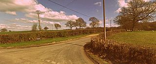
Graylands is a hamlet in the Horsham district of West Sussex, England. The largely rural hamlet is located north of Holbrook beyond the A264. It is bordered by Langhurstwood Road to the west, Old Holbrook to the east, and Green Lane on its northern perimeter.

Shermanbury is a village and civil parish in the Horsham District of West Sussex, England. It lies on the A281 road approximately 2 miles (3 km) north of Henfield. The present day village consists mainly of a ribbon development of bungalows on the east side of the A281, while the ancient parish church is to the east by Shermanbury Place. Between these is Ewhurst Manor, a 16th-century house on an old moated site with a 14th-century stone gatehouse and nearby artificial lake and farmstead.
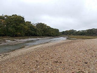
King's Quay is a place on the north east coast of the Isle of Wight, an island off the South Coast of England. It comprises the estuary of a stream called Palmer's Brook, situated between East Cowes and Wootton Creek, about 2 miles (3.2 km) north west of Wootton. It is said, probably apocryphally, to have been the place that King John fled to after signing Magna Carta, from which it derives its name.
Trodds Copse is a 25.23 hectare biological Site of Special Scientific Interest (SSSI), in central Hampshire, notified in 1989. It comprises ancient semi-natural woodland, unimproved meadows and flushes.

Burghfield Brook is a small stream in southern England. It rises in Wokefield Common between the Berkshire villages of Mortimer and Burghfield Common. It is a tributary of Foudry Brook, which it joins near Hartley Court Farm, just to the south of the M4 motorway.

Clayhill Brook is a small stream in southern England, in the county of Berkshire.

Morleys Hall, a moated hall converted to two houses, is situated at grid reference SJ 689 992 on Morleys Lane, on the edge of Astley Moss in Astley in the historic county of Lancashire and the ceremonial county of Greater Manchester, England. It was largely rebuilt in the 19th century on the site of a medieval timber house. The hall is a Grade II* listed building and the moat a scheduled ancient monument. Morleys is a private residence.

Stratton Park Moated Enclosure is a scheduled ancient monument formed of a moat ditch circuit, counterscarp bank, central platform and walled garden compound located on the south-east edge of Biggleswade, Bedfordshire in the United Kingdom. Described by a 1982–83 survey of the landscape and wildlife features at Biggleswade as "one of the most exciting areas seen during the survey" and by English Heritage as "a site of regional significance", the moated enclosure consists of a number of earthwork features discovered through topographical analysis. Classified by the Royal Commission on the Historical Monuments of England as a Class A: Homestead Moat site, the moated enclosure is not currently open to the general public.

Old Copse, Beenham is an 8-hectare (20-acre) biological Site of Special Scientific Interest south of Beenham in Berkshire. The site is private land with no public access.

McIlroy Park is a 12-hectare (30-acre) Local Nature Reserve in Tilehurst, a suburb of Reading in Berkshire. It is owned and managed by Reading Borough Council. Along with Blundells Copse and Lousehill Copse it is part of West Reading Woodlands.
Clayfield Copse is a local nature reserve on the northern edge of the suburb of Caversham in Reading, UK. The site is 8.65 hectares in size and is a natural open space consisting of fields, wild flower meadow and native woodlands adjoining the Oxfordshire countryside. Some of the woodland is being actively managed as hazel coppice, and traditional dead hedging defines some of the ancient woodland areas. The site is the only outcrop of London Clay north of the River Thames in Reading and makes up the southern tip of the Chiltern Hills. The nature reserve is under the management of the Reading Borough Council.
Old Holbrook is a hamlet in the Horsham district of West Sussex, England. This rural hamlet is located north of the Horsham residential area of Holbrook beyond the A264. It is bordered by Graylands to the west, Wimlands to the east, and Green Lane on its northern perimeter.

Upper Rapeland Wood is a mixed mature woodland in Old Holbrook, a hamlet close to Horsham, England. It lies on Rapeland Hill, on the north-western fringes of Old Holbrook, 1.2 miles (1.94 km) north of the A264 dual carriageway. It is directly opposite Northlands Copse, an area of ancient woodland and a partially managed plantation in the neighbouring hamlet of Graylands.

Bow Brook is a small river in the English county of Hampshire, which is a tributary of the River Loddon. Contributary streams rise near Ramsdell and Sherborne St John, and after flowing through rural countryside, it joins the Loddon near Sherfield on Loddon. Historically it has powered at least two watermills.


