Grease trail

Last updated
Eulachon Eulachon.jpg
Eulachon

A grease trail is an overland trade route, part of a network of trails connecting the Pacific coast with the Interior in the Pacific Northwest.

Contents

History

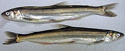
Trails were developed for trade between indigenous people, particularly the trade in eulachon oil (also spelled oolichan oil). [1] The grease from these small fish could be traded for furs, copper, and obsidian, among other things. The Stó:lō people of the Fraser River simply ate the fish, either fresh or smoked, but the people of the interior used the oil as a condiment (similar to butter) and in various other ways.

Origin of the name

"Grease Trail", Carrier /tl'inaɣeti/. The name comes from the fact that the most important item traded into the interior was the processed oil of the eulachon fish Thaleichthys pacificus. Indeed, the Carrier word /tl'inaɣe/ "eulachon oil" is a compound of Carrier /xe/ "grease, oil" (combining form /ɣe/) with /tl'ina/, a loan from Heiltsuk or Haisla, North Wakashan languages spoken on the coast. [2]

"Because these trails were commonly used to transport Oolichan grease, they are now referred to as 'grease trails.' For thousands of years, First Nations traders followed well-trodden 'grease trails,' usually the easiest routes across plateaus, highlands and over challenging mountains far into the western interior, back-packing heavy boxes of valuable Oolichan grease, held in place by cedar rope 'tump-lines,' attached to headbands. The trails, operating on a relay system, covered a geographic area from what is now the Yukon Territories in Canada south to what is now northern California in the United States and as far east as central Montana and Alberta, to interior peoples like the Babine, Carrier and other Athabaskans." [3]

Grease trails and former grease trails

Citations

  1. "Grease Trails". Living Landscapes. Retrieved November 6, 2012.
  2. "Words from the West". Language Log. September 27, 2004. Retrieved November 6, 2012.
  3. Hirch 2003, p. 3.

Related Research Articles

Cascade Range Mountain range in western North America

The Cascade Range or Cascades is a major mountain range of western North America, extending from southern British Columbia through Washington and Oregon to Northern California. It includes both non-volcanic mountains, such as the North Cascades, and the notable volcanoes known as the High Cascades. The small part of the range in British Columbia is referred to as the Canadian Cascades or, locally, as the Cascade Mountains. The latter term is also sometimes used by Washington residents to refer to the Washington section of the Cascades in addition to North Cascades, the more usual U.S. term, as in North Cascades National Park. The highest peak in the range is Mount Rainier in Washington at 14,411 feet (4,392 m).

Chehalis people

The Chehalis people or Tsihalis are a native people of western Washington state in the United States. They should not be confused with the similarly named Chehalis First Nation of the Sts'Ailes people along the Harrison River in the Fraser Valley area of British Columbia.

Dakelh

The Dakelh or Carrier are the indigenous people of a large portion of the Central Interior of British Columbia, Canada.

Stikine River River in British Columbia and Alaska

The Stikine River is a major river in northern British Columbia, Canada and southeastern Alaska in the United States. Draining a large, remote upland area known as the Stikine Country east of the Coast Mountains, it flows west and south for 610 kilometres (379 mi), emptying into various straits of the Inside Passage near Wrangell, Alaska. About 90 percent of the river's length and 95 percent of its drainage basin are in Canada. Considered one of the last truly wild large rivers in British Columbia, the Stikine flows through a variety of landscapes including boreal forest, steep canyons and wide glacial valleys.

Dalton Trail

The Dalton Trail is a trail that runs between Pyramid Harbor, west of Haines, Alaska in the United States, and Fort Selkirk, in the Yukon Territory of Canada, using the Chilkat Pass. It is 396 km (246 mi) long.

Eulachon Species of fish

The eulacheon, also called the candlefish, is a small anadromous species of smelt that spawns in some of the major river systems along the Pacific coast of North America from northern California to Alaska.

Nisgaa Indigenous people of Canada

The Nisga’a, often formerly spelled Nishga and spelled in the Nisga’a language as Nisg̱a’a, are an Indigenous people of Canada in British Columbia. They reside in the Nass River valley of northwestern British Columbia. The name is a reduced form of [naːsqaʔ], which is a loan word from Tongass Tlingit, where it means "people of the Nass River".

Haisla people

The Haisla are an amalgamation of two bands, the Kitamaat people of upper Douglas Channel and Devastation Channel and the Kitlope People of upper Princess Royal Channel and Gardner Canal in British Columbia, Canada.

Tsilhqotʼin Indigenous people in British Columbia, Canada

The Tsilhqotʼin or Chilcotin are a North American tribal government of the Athabaskan-speaking ethnolinguistic group that live in what is now known as British Columbia, Canada. They are the most southern of the Athabaskan-speaking Indigenous peoples in British Columbia.

Indigenous peoples of the Northwest Plateau

Indigenous peoples of the Northwest Plateau, also referred to by the phrase Indigenous peoples of the Plateau, and historically called the Plateau Indians are indigenous peoples of the Interior of British Columbia, Canada, and the non-coastal regions of the Northwestern United States.

Fraser Canyon

The Fraser Canyon is a major landform of the Fraser River where it descends rapidly through narrow rock gorges in the Coast Mountains en route from the Interior Plateau of British Columbia to the Fraser Valley. Colloquially, the term "Fraser Canyon" is often used to include the Thompson Canyon from Lytton to Ashcroft, since they form the same highway route which most people are familiar with, although it is actually reckoned to begin above Williams Lake, British Columbia at Soda Creek Canyon near the town of the same name.

Stuart Lake Body of water

Stuart Lake, or Nak'albun in the Carrier (Dakelh) language is a lake situated in the Northern Interior of British Columbia, Canada. The town of Fort St. James is situated by the lake near the outlet. Stuart Lake is 66 kilometres (41 mi) long, 10 kilometres (6.2 mi) wide and relatively shallow, with an average depth of 26 metres (85 ft).

Interior Plateau Region in Interior of British Columbia, Canada

The Interior Plateau comprises a large region of the Interior of British Columbia, and lies between the Cariboo and Monashee Mountains on the east, and the Hazelton Mountains, Coast Mountains and Cascade Range on the west. The continuation of the plateau into the United States is known there as the Columbia Plateau.

The Klinaklini River is one of the major rivers of the Pacific Ranges section of the Coast Mountains in the Canadian province of British Columbia. It originates in the Pantheon Range and empties into the head of Knight Inlet.

West Road River

The West Road River or Blackwater River or Tiyakoh is an important tributary of the Fraser River, flowing generally north-eastward from the northern slopes of the Ilgachuz Range and across the Fraser Plateau in the Chilcotin region of central British Columbia, Canada. With only one major tributary, the Nazko River, its confluence with the Fraser is approximately 40 km northwest of Quesnel. It forms the division between the Chilcotin Plateau (S) and the Nechako Plateau (N), which are subdivisions of the Fraser Plateau.

Alexander MacKenzie Heritage Trail

The Alexander MacKenzie Heritage Trail is a 420 km (260 mi) long historical overland route between Quesnel and Bella Coola, British Columbia, Canada. Of the many grease trails connecting the Coast with the Interior, it is the most notable and often is referred to as the Grease Trail.

Thompson Country

Thompson Country, also referred to as The Thompson and sometimes as the Thompson Valley and historically known as the Couteau Country or Couteau District, is a historic geographic region of the Southern Interior of British Columbia, more or less defined by the basin of the Thompson River. This is a tributary of the Fraser; the major city in the area is Kamloops.

The Cheslatta Carrier Nation or Cheslatta T'En, of the Dakelh or Carrier people (Ta-cullies, meaning "people who go upon water", whose traditional lands where originally where the Kitimat Kemano Project I was built, form a large portion of the Central Interior of present-day British Columbia, Canada, is a First Nation of the Nechako River at the headwaters of the Fraser River.

The Ecstall River is a tributary of the Skeena River in the province of British Columbia, Canada. It originates in the Kitimat Ranges, and flows about 110 km (68 mi) to the lower tidal reach of the Skeena River at Port Essington, about 30 km (19 mi) southeast of Prince Rupert, 95 km (59 mi) southwest of Terrace, and 85 km (53 mi) northwest of Kitimat. Its drainage basin covers about 1,485 km2 (573 sq mi) and contains the largest blocks of unlogged land on the north coast of British Columbia, although large-scale industrial logging operations, both active and proposed, have been occurring in the watershed since the 1980s.

References