
Mount Monadnock, or Grand Monadnock, is a mountain in the town of Jaffrey, New Hampshire. It is the most prominent mountain peak in southern New Hampshire and is the highest point in Cheshire County. It lies 38 miles (61 km) southwest of Concord and 62 miles (100 km) northwest of Boston. At 3,165 feet (965 m), Mount Monadnock is nearly 1,000 feet (305 m) higher than any other mountain peak within 30 miles (48 km) and rises 2,000 feet (610 m) above the surrounding landscape. Monadnock's bare, isolated, and rocky summit provides expansive views. It is known for being featured in the writings of Ralph Waldo Emerson and Henry David Thoreau.
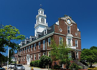
Weymouth is a city in Norfolk County, Massachusetts, United States. It is one of 13 municipalities in the state to have city forms of government while retaining "town of" in their official names. It is named after Weymouth, Dorset, a coastal town in England, and is the second-oldest settlement in Massachusetts, second only to Plymouth. It is one of the South Shore's more affordable towns and offers a short commute into Boston, MBTA bus and rail service, and a town beach.

Mount Katahdin is the highest mountain in the U.S. state of Maine at 5,269 feet (1,606 m). Named Katahdin, which means "Great Mountain", by the Penobscot Native Americans, it is within Northeast Piscataquis, Piscataquis County, and is the centerpiece of Baxter State Park. It is a steep, tall massif formed from a granite intrusion weathered to the surface. The flora and fauna on the mountain are typical of those found in northern New England, with the summit hosting fragile and endangered alpine tundra.

Capulin Volcano National Monument is a U.S. National Monument located in northeastern New Mexico that protects and interprets an extinct cinder cone volcano and is part of the Raton-Clayton volcanic field. A paved road spirals gradually around the volcano and visitors can drive up to a parking lot at the rim of the extinct volcano. Hiking trails circle the rim and lead down into the mouth of the volcano. The monument was designated on August 9, 1916, and is administered by the National Park Service. The volcano is located 5 kilometres (3.1 mi) north of the village of Capulin.
Birds Hill Provincial Park is a provincial park in Manitoba, Canada located in the Boreal Plains ecozone. The park protects areas representative of Aspen/Oak parkland, as well as provides opportunities for recreation. It is located 24 kilometers north of Winnipeg on Highway 59, and covers approximately 8,300 acres or 35.1 km2.

Great Blue Hill is a hill of 635 feet located within the Blue Hills Reservation in Milton, Randolph and Canton, Massachusetts, about 10 miles (16 km) south of downtown Boston. It is the highest point in Norfolk County and the Greater Boston area.

Blue Hills Reservation is a 7,000-acre (2,800 ha) state park in Norfolk County, Massachusetts in the United States. Managed by the Massachusetts Department of Conservation and Recreation, it covers parts of Milton, Quincy, Braintree, Canton, Randolph, and Dedham. Located approximately ten miles south of downtown Boston, the reservation is one of the largest parcels of undeveloped conservation land within the Greater Boston metropolitan area. The park's varied terrain and scenic views make it a popular destination for hikers from the Boston area.

Difficult Run is a 15.9-mile-long (25.6 km) tributary stream of the Potomac River in Northern Virginia in the United States. The area has had many historical uses dating back to the early 1800s. Today, the area is used recreationally by visitors interested in the watershed's variety of options including hiking, biking, fishing, boating, climbing, and bird watching. The wildlife at Difficult Run is vast as 163 different species can be seen depending on the season. There are 41 different soil types found on the trail and alongside the stream. The stream is part of the greater 57.7- square-mile Drainage basin, or watershed, located in the north-central portion of Fairfax County, Virginia and drains directly to the Potomac River.
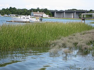
The Weymouth Back River, sometimes called Back River, is a short, primarily tidal river in Hingham and Weymouth, Massachusetts, about 10 miles (16 km) south of Boston. It arises from a number of tributaries in ponds and swamps, most notably Whitmans Pond, flows northward, and empties into Hingham Bay just south of Grape Island and Slate Island.

Bartholomew's Cobble is a 329-acre (1.33 km2) National Natural Landmark, open space preserve, agricultural preserve, and bio-reserve located in southwest Massachusetts in the village of Ashley Falls abutting Canaan, Connecticut. The preserve contains more than 800 plant species, including North America's greatest diversity of ferns and the greatest overall biodiversity in Berkshire County, Massachusetts; it also contains Massachusetts' highest populations of ground nesting bobolinks. It was declared a National Natural Landmark in October 1971.

The Ipswich River Wildlife Sanctuary, which is one of the Massachusetts Audubon Society’s largest wildlife sanctuaries, is located in Topsfield and Wenham, Massachusetts. Much of its 1,955-acre (7.91 km2) landscape was created by a glacier 15,000 years ago.

Tumalo State Park is a well-developed state park in Deschutes County, Oregon, United States. Established in 1954, the park is located northwest of the city of Bend and along the Deschutes River at a site home to many bird species. The park is popular for picnics, swimming, fishing, hiking, and camping, and is open year-round.
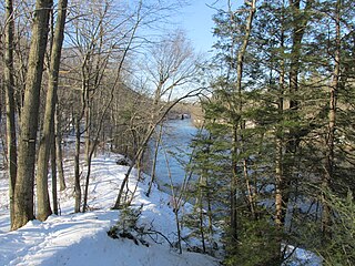
Robinson State Park is a state-owned, public recreation area located mostly in the town of Agawam with a small section in Westfield, Massachusetts. The narrow, 1,025-acre (415 ha) state park follows the course of the meandering Westfield River which forms the park's northern border. The park is managed by the Massachusetts Department of Conservation and Recreation.

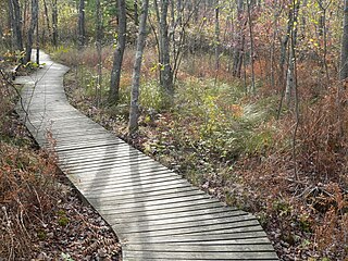
Cutler Park is a state-owned nature preserve and public recreation area that lies between Route 128/I-95 and the Charles River in Needham, Massachusetts. The state park's 772 acres (312 ha) contain the largest remaining freshwater marsh on the middle Charles River. Parts of its major trail run directly through the marsh via boardwalks; over 100 species of birds have been sighted here. The park is part of a plan by the Town of Needham to connect 18 public areas by 35 proposed trails. It is managed by the Massachusetts Department of Conservation and Recreation.
Moose Hill Wildlife Sanctuary is a 1,971 acres (798 ha) wildlife sanctuary located in Sharon, Massachusetts. The property is the oldest property of the Massachusetts Audubon Society, established in 1916. It is adjacent to Moose Hill Farm, which is owned by the Trustees of Reservations.

Weymouth Back River Reservation is a protected coastal reservation in Hingham and Weymouth, Massachusetts. It contains parks on the west and east sides of the northern end of Weymouth Back River. On the west side in Weymouth, Abigail Adams Park is adjacent to and north of Route 3A Bridge and Great Esker Park is south of the bridge. On the east side in Hingham, Stodder's Neck is north of the bridge and Bare Cove Park is south of the bridge. It features Weymouth Back River views, walking trails and landscaped areas.

The Tunxis Trail is a 79-mile (127 km) Blue-Blazed hiking trail "system" that traverses the western ridge of the central Connecticut Valley. The mainline trail is not completely contiguous, notably there are two gaps of several miles.

The Housatonic Range Trail is a 6.2-mile (10.0 km) Blue-Blazed hiking trail on Candlewood Mountain in the town of New Milford. The north-south axis of the trail parallels the Housatonic River through private land and land trust parcels. The Housatonic Range Trail is maintained largely through the efforts of the Connecticut Forest and Park Association, which provides online Blue Trail maps.

Grafton Notch State Park is a public recreation area in Grafton Township, Oxford County, Maine. The state park occupies 3,129 acres (1,266 ha) surrounding Grafton Notch, the mountain pass between Old Speck Mountain and Baldpate Mountain, mountains in the Mahoosuc Range. The park is abutted by the eastern and western sections of the Mahoosuc Public Reserved Land, which total 31,807 acres (12,872 ha). The park is managed by the Department of Agriculture, Conservation and Forestry.
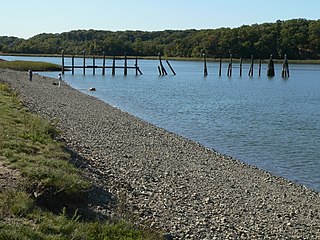
Bare Cove Park is a 484 acre park designated for wildlife and public recreation. It is located in Hingham, Massachusetts, on the Weymouth Back River across from Great Esker Park.


