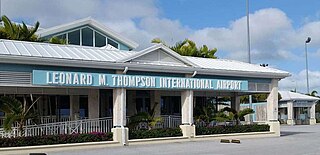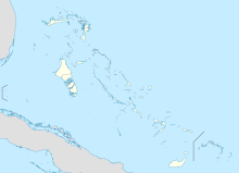
Leonard M. Thompson International Airport, formerly known as The Marsh Harbour International Airport, is an airport serving Marsh Harbour, a town in the Abaco Islands, The Bahamas. Marsh Harbour is a major tourist attraction. The airport offers scheduled passenger flights to Nassau and several destinations in Florida as well as regional jet flights nonstop to three major U.S. hubs, Atlanta, Charlotte and Miami in the U.S. In 2007 a new runway was built to allow larger, regional jets to operate from Marsh Harbour. A new airport terminal opened on 27 May 2014.
Andros Town Airport or Andros Town International Airport is an airport serving Andros Town on Andros Island in the Bahamas. It is also known as Fresh Creek Airport.
Deadman's Cay Airport is an airport located near Deadman's Cay on Long Island in The Bahamas. The airport serves the island’s capital, Clarence Town, as well as the general south of the island.
San Andros Airport is an airport near Nicholls Town on Andros Island in The Bahamas.
Spring Point Airport is an airport serving Spring Point on Acklins Island in The Bahamas. Bahamasair flies to Spring Point Airport, and it is the only airline that flies here.

New Bight Airport is an airport in New Bight on Cat Island in The Bahamas. The airport has domestic passenger flights to one destination, Nassau. The flight to Nassau from New Bight Airport is 84 miles and takes on average 30 minutes.
Treasure Cay Airport is an airport serving Treasure Cay, in the Abaco Islands in The Bahamas.

Orestes Acosta Airport is a regional airport that serves Moa, a municipality in the Holguín Province of Cuba.
Clarence A. Bain Airport is an airport serving Mangrove Cay, one of the districts of the Bahamas, on Andros Island.
South Andros Airport is an airport near Congo Town. In South Andros, part of Andros Island is in The Bahamas. It is also known as Congo Town Airport.
North Caicos Airport is an airport serving North Caicos, the second largest of the Turks and Caicos Islands.
Salt Cay Airport is the public airport serving Salt Cay, the second largest of the Turks Islands in the Turks and Caicos Islands. The facility is also known as Leon Wilson Airport.
South Caicos Airport is an airport serving South Caicos, the seventh largest of the Turks and Caicos Islands.
Spanish Cay Airport is an airstrip serving Spanish Cay, one of the Abaco Islands in The Bahamas.
George Town Airport is an abandoned airport located near George Town on the island of Great Exuma in The Bahamas which is closed for civilian use.

Norman's Cay Airport is an airport serving Norman's Cay, one of the Exuma Islands in The Bahamas. It was known for cocaine drug smuggling from Colombia to the United States under Carlos Lehder.

Staniel Cay Airport is an airport serving Staniel Cay, one of the Exuma Islands in The Bahamas.
Stella Maris Airport is an airport located near Stella Maris on Long Island in The Bahamas.
Duncan Town Airport is an airport located near Duncan Town, on Ragged Island in The Bahamas.
Port Nelson Airport or New Port Nelson Airport is an airport located near Port Nelson, on Rum Cay in The Bahamas.


