Great Lakes water resource region

Last updated

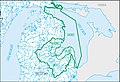
The Great Lakes water resource region is one of 21 major geographic areas, or regions, in the first level of classification used by the United States Geological Survey to divide and sub-divide the United States into successively smaller hydrologic units. These geographic areas contain either the drainage area of a major river, or the combined drainage areas of a series of rivers. [1] [2]

Contents

The Great Lakes region, which is listed with a 2-digit hydrologic unit code (HUC) of 04, has an approximate size of 141,984 square miles (367,740 square kilometers ), and consists of 15 subregions, which are listed with the 4-digit HUCs 0401 through 0415.

This region includes the drainage within the United States that ultimately discharges into: (a) the Great Lakes system, including the lake surfaces, bays, and islands; and (b) the St. Lawrence River to the Riviere Richelieu drainage boundary. Includes parts of Illinois, Indiana, Michigan, Minnesota, New York, Ohio, Pennsylvania, and Wisconsin. [3]

The Great Lakes region, with its 15 4-digit sub-region hydrologic unit boundaries. HUC04.jpg
The Great Lakes region, with its 15 4-digit sub-region hydrologic unit boundaries.

List of water resource subregions

Subregion HUC [4] Subregion Name [4] Subregion Description [3] Subregion Location [4] Subregion Size [4] Subregion Map
0401 Western Lake Superior Subregion The drainage into Lake Superior within the United States from the Ontario-Minnesota international boundary to and including the Montreal River Basin.Michigan, Minnesota, and Wisconsin.9,240 sq mi (23,900 km2)
HUC0401 HUC0401.jpg
HUC0401
0402 Southern Lake Superior–Lake Superior Subregion The drainage into Lake Superior within the United States from the Montreal River Basin boundary to the Soo Locks at Sault Sainte Marie, and Lake Superior within the United States, including its bays and islands.Michigan, Minnesota, and Wisconsin.28,600 sq mi (74,000 km2)
HUC0402 HUC0402.jpg
HUC0402
0403 Northwestern Lake Michigan Subregion The drainage into Lake Michigan from the Milwaukee River Basin boundary to the Manistique River Basin boundary.Michigan and Wisconsin18,700 sq mi (48,000 km2)
HUC0403 HUC0403.jpg
HUC0403
0404 Southwestern Lake Michigan Subregion The drainage into Lake Michigan from the St. Joseph River Basin boundary to and including the Milwaukee River Basin.Illinois, Indiana, Michigan, and Wisconsin.1,970 sq mi (5,100 km2)
HUC0404 HUC0404.jpg
HUC0404
0405 Southeastern Lake Michigan Subregion The drainage into Lake Michigan from and including the St. Joseph River Basin to and including the Grand River Basin.Indiana and Michigan.12,800 sq mi (33,000 km2)
HUC0405 HUC0405.jpg
HUC0405
0406 Northeastern Lake Michigan–Lake Michigan Subregion 
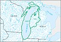
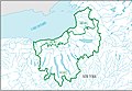
The drainage into Lake Michigan from the Grand River Basin boundary to and including the Manistique River Basin, and Lake Michigan, including its Bays and Islands.Illinois, Indiana, Michigan, and Wisconsin.33,600 sq mi (87,000 km2)
HUC0406 HUC0406.jpg
HUC0406
0407 Northwestern Lake Huron Subregion The drainage into Lake Huron within the United States from the Soo Locks at Sault Sainte Marie to and including the Au Sable River Basin.Michigan7,110 sq mi (18,400 km2)
HUC0407 HUC0407.jpg
HUC0407
0408 Southwestern Lake Huron–Lake Huron Subregion 
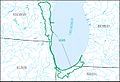
The drainage into Lake Huron within the United States, from the Au Sable River Basin boundary to the St. Clair River Basin boundary at the mouth of Lake Huron, and Lake Huron within the United States, including its bays and islands.Michigan18,000 sq mi (47,000 km2)
HUC0408 HUC0408.jpg
HUC0408
0409 St. Clair–Detroit Subregion 
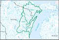
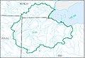
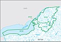
The St. Clair and Detroit River Basins within the United States from the mouth of Lake Huron to and including the Huron River Basin, and Lake St. Clair within the United States.Michigan3,960 sq mi (10,300 km2)
HUC0409 HUC0409.jpg
HUC0409
0410 Western Lake Erie Subregion The drainage into Lake Erie from the Huron River Basin boundary to and including the Vermilion River Basin.Indiana, Michigan, and Ohio.11,900 sq mi (31,000 km2)
HUC0410 HUC0410.jpg
HUC0410
0411 Southern Lake Erie Subregion The drainage into Lake Erie from the Vermilion River Basin boundary to and including the Ashtabula River Basin.Ohio and Pennsylvania.3,030 sq mi (7,800 km2)
HUC0411 HUC0411.jpg
HUC0411
0412 Eastern Lake Erie–Lake Erie Subregion 
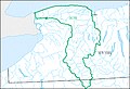
The drainage into Lake Erie within the United States from the Ashtabula River Basin boundary to and including the Niagara River Basin, and Lake Erie within the United States, including its bays and islands.Michigan, New York, Ohio, and Pennsylvania.7,740 sq mi (20,000 km2)
HUC0412 HUC0412.jpg
HUC0412
0413 Southwestern Lake Ontario Subregion The drainage into Lake Ontario from the Niagara River Basin boundary to and including the Genesee River Basin.New York and Pennsylvania.3,540 sq mi (9,200 km2)
HUC0413 HUC0413.jpg
HUC0413
0414 Southeastern Lake Ontario Subregion The drainage into Lake Ontario from the Genesee River Basin boundary to and including the Stony Creek Basin.New York6,710 sq mi (17,400 km2)
HUC0414 HUC0414.jpg
HUC0414
0415 Northeastern Lake Ontario–Lake Ontario–St. Lawrence Subregion 
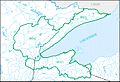
The drainage into Lake Ontario and the St. Lawrence River Basin within the United States from the Stony Creek Basin boundary to and including the English River Basin, and Lake Ontario within the United States, including its bays and islands.New York11,400 sq mi (30,000 km2)
HUC0415 HUC0415.jpg
HUC0415

See also

Related Research Articles

<span class="mw-page-title-main">South Atlantic–Gulf water resource region</span> Drainage region

The South Atlantic–Gulf water resource region is one of 21 major geographic areas, or regions, in the first level of classification used by the United States Geological Survey to divide and sub-divide the United States into successively smaller hydrologic units. These geographic areas contain either the drainage area of a major river, or the combined drainage areas of a series of rivers.

<span class="mw-page-title-main">Mid Atlantic water resource region</span> US hydrologic region

The Mid Atlantic water resource region is one of 21 major geographic areas, or regions, in the first level of classification used by the United States Geological Survey to divide and sub-divide the United States into successively smaller hydrologic units. These geographic areas contain either the drainage area of a major river, or the combined drainage areas of a series of rivers.

<span class="mw-page-title-main">Upper Mississippi water resource region</span>

The Upper Mississippi water resource region is one of 21 major geographic areas, or regions, in the first level of classification used by the United States Geological Survey to divide and sub-divide the United States into successively smaller hydrologic units. These geographic areas contain either the drainage area of a major river, or the combined drainage areas of a series of rivers.

<span class="mw-page-title-main">Lower Mississippi water resource region</span>

The Lower Mississippi water resource region is one of 21 major geographic areas, or regions, in the first level of classification used by the United States Geological Survey to divide and sub-divide the United States into successively smaller hydrologic units. These geographic areas contain either the drainage area of a major river, or the combined drainage areas of a series of rivers.

<span class="mw-page-title-main">Missouri water resource region</span>

The Missouri water resource region is one of 21 major geographic areas, or regions, in the first level of classification used by the United States Geological Survey to divide and sub-divide the United States into successively smaller hydrologic units. These geographic areas contain either the drainage area of a major river, or the combined drainage areas of a series of rivers.

<span class="mw-page-title-main">Ohio water resource region</span>

The Ohio water resource region is one of 21 major geographic areas, or regions, in the first level of classification used by the United States Geological Survey to divide and sub-divide the United States into successively smaller hydrologic units. These geographic areas contain either the drainage area of a major river, or the combined drainage areas of a series of rivers.

<span class="mw-page-title-main">Tennessee water resource region</span>

The Tennessee water resource region is one of 21 major geographic areas, or regions, in the first level of classification used by the United States Geological Survey to divide and sub-divide the United States into successively smaller hydrologic units. These geographic areas contain either the drainage area of a major river, or the combined drainage areas of a series of rivers.

<span class="mw-page-title-main">Rio Grande water resource region</span>

The Rio Grande water resource region is one of 21 major geographic areas, or regions, in the first level of classification used by the United States Geological Survey to divide and sub-divide the United States into successively smaller hydrologic units. These geographic areas contain either the drainage area of a major river, or the combined drainage areas of a series of rivers.

<span class="mw-page-title-main">Upper Colorado water resource region</span> Major geographic area

The Upper Colorado water resource region is one of 21 major geographic areas, or regions, in the first level of classification used by the United States Geological Survey to divide and sub-divide the United States into successively smaller hydrologic units. These geographic areas contain either the drainage area of a major river, or the combined drainage areas of a series of rivers.

<span class="mw-page-title-main">Lower Colorado water resource region</span> Major geographic area

The Lower Colorado water resource region is one of 21 major geographic areas, or regions, in the first level of classification used by the United States Geological Survey to divide and sub-divide the United States into successively smaller hydrologic units. These geographic areas contain either the drainage area of a major river, or the combined drainage areas of a series of rivers.

<span class="mw-page-title-main">Great Basin water resource region</span>

The Great Basin water resource region is one of 21 major geographic areas, or regions, in the first level of classification used by the United States Geological Survey to divide and sub-divide the United States into successively smaller hydrologic units. These geographic areas contain either the drainage area of a major river, or the combined drainage areas of a series of rivers.

<span class="mw-page-title-main">Pacific Northwest water resource region</span>

The Pacific Northwest water resource region is one of 21 major geographic areas, or regions, in the first level of classification used by the United States Geological Survey to divide and sub-divide the United States into successively smaller hydrologic units. These geographic areas contain either the drainage area of a major river, or the combined drainage areas of a series of rivers.

<span class="mw-page-title-main">California water resource region</span> Surface water, first-level USGS hydrologic system subdivision

The California water resource region is one of 21 major geographic areas, or regions, in the first level of classification used by the United States Geological Survey in the United States hydrologic unit system, which is used to divide and sub-divide the United States into successively smaller hydrologic units. These geographic areas contain either the drainage area of a major river, or the combined drainage areas of a series of rivers.

<span class="mw-page-title-main">Alaska water resource region</span>

The Alaska water resource region is one of 21 major geographic areas, or regions, in the first level of classification used by the United States Geological Survey to divide and sub-divide the United States into successively smaller hydrologic units. These geographic areas contain either the drainage area of a major river, or the combined drainage areas of a series of rivers.

<span class="mw-page-title-main">Hawaii water resource region</span>

The Hawaii water resource region is one of 21 major geographic areas, or regions, in the first level of classification used by the United States Geological Survey to divide and sub-divide the United States into successively smaller hydrologic units. These geographic areas contain either the drainage area of a major river, or the combined drainage areas of a series of rivers.

<span class="mw-page-title-main">Caribbean water resource region</span>

The Caribbean water resource region is one of 21 major geographic areas, or regions, in the first level of classification used by the United States Geological Survey to divide and sub-divide the United States into successively smaller hydrologic units. These geographic areas contain either the drainage area of a major river, or the combined drainage areas of a series of rivers.

<span class="mw-page-title-main">Souris–Red–Rainy water resource region</span>

The Souris–Red–Rainy region is one of 21 major geographic areas, or regions, in the first level of classification used by the United States Geological Survey to divide and sub-divide the United States into successively smaller hydrologic units. These geographic areas contain either the drainage area of a major river, or the combined drainage areas of a series of rivers.

<span class="mw-page-title-main">Texas–Gulf water resource region</span>

The Texas–Gulf water resource region is one of 21 major geographic areas, or regions, in the first level of classification used by the United States Geological Survey to divide and sub-divide the United States into successively smaller hydrologic units. These geographic areas contain either the drainage area of a major river, or the combined drainage areas of a series of rivers.

<span class="mw-page-title-main">Arkansas–White–Red water resource region</span>

The Arkansas–White–Red water resource region is one of 21 major geographic areas, or regions, in the first level of classification used by the United States Geological Survey to divide and sub-divide the United States into successively smaller hydrologic units. These geographic areas contain either the drainage area of a major river, or the combined drainage areas of a series of rivers.

<span class="mw-page-title-main">Northern Mojave–Mono Lake water resource subregion</span> Second-level USGS hydrologic unit system subdivision

Northern Mojave–Mono Lake water resource subregion is one of 10 water resource subregions within the California water resource region and is one of 222 water resource subregions in the federally organized United States hydrologic unit system.

References

  1. "Science in Your Watershed – Locate Your Watershed". USGS. Archived from the original on 2016-03-24. Retrieved 2016-10-12.PD-icon.svg This article incorporates text from this source, which is in the public domain .
  2. "Hydrologic Unit Maps". USGS. Archived from the original on 2016-11-21. Retrieved 2016-10-12.PD-icon.svg This article incorporates text from this source, which is in the public domain .
  3. 1 2 "Boundary Descriptions and Names of Regions, Subregions, Accounting Units and Cataloging Units". USGS. Archived from the original on 2016-12-10. Retrieved 2016-10-12.PD-icon.svg This article incorporates text from this source, which is in the public domain .
  4. 1 2 3 4 McManamay RA, Bevelhimer MS, Kao SC, Yaxing W, Martinez-Gonzalez M, Samu N (2013). "National Hydropower Asset Assessment Environmental Attribution". USGS-Oak Ridge National Laboratory. Archived from the original on 2016-10-12. Retrieved 2016-10-12.PD-icon.svg This article incorporates text from this source, which is in the public domain .