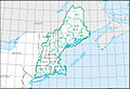
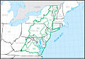
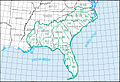
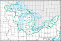
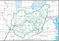
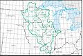
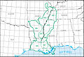
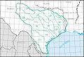
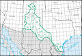
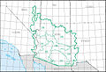
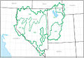
Water resource region

Last updated

A water resource region is the first level of classification used by the United States Geological Survey to divide and sub-divide the United States into successively smaller hydrologic units as part of the U.S. hydrologic unit system.

Contents

This first level of classification divides the United States into 21 major geographic areas, or regions. These geographic areas contain either the drainage area of a major river, or the combined drainage areas of a series of rivers. [1] [2]

The 21 first-level 2-digit region hydrologic unit boundaries. Water Resource Regions of the United States of America.jpg
The 21 first-level 2-digit region hydrologic unit boundaries.

List of water resource regions

Region HUC [3] Region name [3] Region description [4] Region location [3] Region size [3] Region populationRegion map
01 New England region The drainage within the United States that ultimately discharges into:
  1. the Bay of Fundy
  2. the Atlantic Ocean within and between the states of Maine and Connecticut
  3. Long Island Sound north of the New York-Connecticut state line
  4. the Riviere St. Francois, a tributary of the Saint Lawrence River
Includes all of Maine, New Hampshire and Rhode Island, and parts of Connecticut, Massachusetts, New York, and Vermont.73,753 sq mi (191,020 km2)14,500,000
HUC01 HUC01.jpg
HUC01
02 Mid Atlantic region The drainage within the United States that ultimately discharges into:
  1. the Atlantic Ocean within and between the states of New York and Virginia
  2. Long Island Sound south of the New York-Connecticut State Line
  3. the Riviere Richelieu, a tributary of the Saint Lawrence River
Includes all of Delaware and New Jersey and the District of Columbia, and parts of Connecticut, Maryland, Massachusetts, New York, Pennsylvania, Vermont, Virginia, and West Virginia.106,334 sq mi (275,400 km2)50,800,000
HUC02 HUC02.jpg
HUC02
03 South Atlantic–Gulf region The drainage that ultimately discharges into:
  1. the Atlantic Ocean within and between the states of Virginia and Florida
  2. the Gulf of Mexico within and between the states of Florida and Louisiana
  3. the associated waters
Includes all of Florida and South Carolina, and parts of Alabama, Georgia, Louisiana, Mississippi, North Carolina, Tennessee, and Virginia.279,664 sq mi (724,330 km2)55,900,000
HUC03 HUC03.jpg
HUC03
04 Great Lakes region The drainage within the United States that ultimately discharges into:
  1. the Great Lakes system, including the lake surfaces, bays, and islands
  2. the Saint Lawrence River to the Riviere Richelieu drainage boundary.
Includes parts of Illinois, Indiana, Michigan, Minnesota, New York, Ohio, Pennsylvania, and Wisconsin.141,984 sq mi (367,740 km2)15,200,000
HUC04 HUC04.jpg
HUC04
05 Ohio region The drainage of the Ohio River Basin, excluding the Tennessee River Basin.Includes parts of Illinois, Indiana, Kentucky, Maryland, New York, North Carolina, Ohio, Pennsylvania, Tennessee, Virginia and West Virginia.162,916 sq mi (421,950 km2)27,000,000
HUC05 HUC05.jpg
HUC05
06 Tennessee region The drainage of the Tennessee River Basin.Includes parts of Alabama, Georgia, Kentucky, Mississippi, North Carolina, Tennessee, and Virginia.40,908 sq mi (105,950 km2)5,400,000
HUC06 HUC06.jpg
HUC06
07 Upper Mississippi region The drainage of the Mississippi River Basin above the confluence with the Ohio River, excluding the Missouri River Basin.Includes parts of Illinois, Indiana, Iowa, Michigan, Minnesota, Missouri, South Dakota, and Wisconsin.189,968 sq mi (492,010 km2)26,100,000
HUC07 HUC07.jpg
HUC07
08 Lower Mississippi region The drainage of:
  1. the Mississippi River below its confluence with the Ohio River, excluding the Arkansas, Red, and White River Basins above the points of highest backwater effect of the Mississippi River in those basins
  2. coastal streams that ultimately discharge into the Gulf of Mexico from the Pearl River Basin boundary to the Sabine River and Sabine Lake drainage boundary.
Includes parts of Arkansas, Kentucky, Louisiana, Mississippi, Missouri, and Tennessee.106,741 sq mi (276,460 km2)10,400,000
HUC08 HUC08.jpg
HUC08
09 Souris-Red-Rainy region The drainage within the United States of the Lake of the Woods and the Rainy, Red, and Souris River Basins that ultimately discharges into Lake Winnipeg and Hudson Bay.Includes parts of Minnesota, North Dakota, and South Dakota.90,759 sq mi (235,060 km2)1,000,000
HUC09 HUC09.jpg
HUC09
10 Missouri region The drainage within the United States of:
  1. the Missouri River Basin
  2. the Saskatchewan River Basin
  3. several small closed basins.
Includes all of Nebraska and parts of Colorado, Iowa, Kansas, Minnesota, Missouri, Montana, North Dakota, South Dakota, and Wyoming.520,960 sq mi (1,349,300 km2)13,000,000
HUC10 HUC10.jpg
HUC10
11 Arkansas-White-Red region The drainage of the Arkansas, White, and Red River Basins above the points of highest backwater effect of the Mississippi River.Includes all of Oklahoma and parts of Arkansas, Colorado, Kansas, Louisiana, Missouri, New Mexico, and Texas.247,988 sq mi (642,290 km2)11,300,000
HUC11 HUC11.jpg
HUC11
12 Texas-Gulf region The drainage that discharges into the Gulf of Mexico from and including Sabine Pass to the Rio Grande Basin boundary.Includes parts of Louisiana, New Mexico, and Texas.181,886 sq mi (471,080 km2)25,200,000
HUC12 HUC12.jpg
HUC12
13 Rio Grande region The drainage within the United States of:
  1. the Rio Grande Basin
  2. the San Luis Valley, North Plains, Plains of San Agustin, Mimbres River, Estancia, Jornada Del Muerto, Tularosa Valley, Salt Basin, and other closed basins.
Includes parts of Colorado, New Mexico, and Texas.132,517 sq mi (343,220 km2)3,000,000
HUC13 HUC13.jpg
HUC13
14 Upper Colorado region The drainage of:
  1. the Colorado River Basin above the Lee Ferry compact point which is one mile below the mouth of the Paria River
  2. the Great Divide closed basin.
Includes parts of Arizona, Colorado, New Mexico, Utah, and Wyoming.113,347 sq mi (293,570 km2)1,800,000
HUC14 HUC14.jpg
HUC14
15 Lower Colorado region The drainage within the United States of:
  1. the Colorado River Basin below the Lee Ferry compact point which is one mile below the mouth of the Paria River
  2. streams that originate within the United States and ultimately discharge into the Gulf of California
  3. the Animas Valley, Willcox Playa, and other smaller closed basins.
Includes parts of Arizona, California, Nevada, New Mexico, and Utah.140,146 sq mi (362,980 km2)9,900,000
HUC15 HUC15.jpg
HUC15
16 Great Basin region The drainage of the Great Basin that discharges into the states of Utah and Nevada.Includes parts of California, Idaho, Nevada, Oregon, Utah, and Wyoming.141,717 sq mi (367,050 km2)3,900,000
HUC16 HUC16.jpg
HUC16
17 Pacific Northwest region The drainage within the United States that ultimately discharges into:
  1. the Strait of Georgia and of Strait of Juan de Fuca
  2. the Pacific Ocean within the states of Oregon and Washington; and that part of the Great Basin whose discharge is into the state of Oregon.
Includes all of Washington and parts of California, Idaho, Montana, Nevada, Oregon, Utah, and Wyoming.302,334 sq mi (783,040 km2)14,100,000
HUC17 HUC17.jpg
HUC17
18 California region The drainage within the United States that ultimately discharges into the Pacific Ocean within the state of California; and those parts of the Great Basin, or other closed basins, that discharge into the state of California.Includes parts of California, Nevada, and Oregon.168,579 sq mi (436,620 km2)38,900,000
HUC18 HUC18.jpg
HUC18
19 Alaska region The drainage within the state of Alaska.Includes all of Alaska.720,535 sq mi (1,866,180 km2)720,000
HUC19 HUC19.jpg
HUC19
20 Hawaii region The drainage within the state of Hawaii.Includes all of Hawaii.6,428 sq mi (16,650 km2)1,400,000
HUC20 HUC20.jpg
HUC20
21 Caribbean region The drainage within:
  1. the Commonwealth of Puerto Rico
  2. the Virgin Islands of the United States
  3. other United States Caribbean outlying areas.
Includes land areas over which the United States has some degree of interest, jurisdiction, or sovereignty.3,582 sq mi (9,280 km2)3,400,000
HUC21 HUC21.jpg
HUC21
22South Pacific region Guam, the Northern Mariana Islands, and American Samoa 496.48 sq mi (1,285.9 km2)280,000

Related Research Articles

<span class="mw-page-title-main">South Atlantic–Gulf water resource region</span> Drainage region

The South Atlantic–Gulf water resource region is one of 21 major geographic areas, or regions, in the first level of classification used by the United States Geological Survey to divide and sub-divide the United States into successively smaller hydrologic units. These geographic areas contain either the drainage area of a major river, or the combined drainage areas of a series of rivers.

<span class="mw-page-title-main">New England water resource region</span> US hydrologic region

The New England water resource region is one of 21 major geographic areas, or regions, in the first level of classification used by the United States Geological Survey to divide and sub-divide the United States into successively smaller hydrologic units. These geographic areas contain either the drainage area of a major river, or the combined drainage areas of a series of rivers. The New England region, which is listed with a 2-digit hydrologic unit code (HUC) of 01, has an approximate size of 73,753 square miles, and consists of 11 sub-regions, which are listed with the 4-digit HUCs 0101 through 0111.

<span class="mw-page-title-main">Mid Atlantic water resource region</span> US hydrologic region

The Mid Atlantic water resource region is one of 21 major geographic areas, or regions, in the first level of classification used by the United States Geological Survey to divide and sub-divide the United States into successively smaller hydrologic units. These geographic areas contain either the drainage area of a major river, or the combined drainage areas of a series of rivers.

<span class="mw-page-title-main">Upper Mississippi water resource region</span>

The Upper Mississippi water resource region is one of 21 major geographic areas, or regions, in the first level of classification used by the United States Geological Survey to divide and sub-divide the United States into successively smaller hydrologic units. These geographic areas contain either the drainage area of a major river, or the combined drainage areas of a series of rivers.

<span class="mw-page-title-main">Lower Mississippi water resource region</span>

The Lower Mississippi water resource region is one of 21 major geographic areas, or regions, in the first level of classification used by the United States Geological Survey to divide and sub-divide the United States into successively smaller hydrologic units. These geographic areas contain either the drainage area of a major river, or the combined drainage areas of a series of rivers.

<span class="mw-page-title-main">Missouri water resource region</span>

The Missouri water resource region is one of 21 major geographic areas, or regions, in the first level of classification used by the United States Geological Survey to divide and sub-divide the United States into successively smaller hydrologic units. These geographic areas contain either the drainage area of a major river, or the combined drainage areas of a series of rivers.

<span class="mw-page-title-main">Great Lakes water resource region</span>

The Great Lakes water resource region is one of 21 major geographic areas, or regions, in the first level of classification used by the United States Geological Survey to divide and sub-divide the United States into successively smaller hydrologic units. These geographic areas contain either the drainage area of a major river, or the combined drainage areas of a series of rivers.

<span class="mw-page-title-main">Ohio water resource region</span>

The Ohio water resource region is one of 21 major geographic areas, or regions, in the first level of classification used by the United States Geological Survey to divide and sub-divide the United States into successively smaller hydrologic units. These geographic areas contain either the drainage area of a major river, or the combined drainage areas of a series of rivers.

<span class="mw-page-title-main">Tennessee water resource region</span>

The Tennessee water resource region is one of 21 major geographic areas, or regions, in the first level of classification used by the United States Geological Survey to divide and sub-divide the United States into successively smaller hydrologic units. These geographic areas contain either the drainage area of a major river, or the combined drainage areas of a series of rivers.

<span class="mw-page-title-main">Upper Colorado water resource region</span> Major geographic area

The Upper Colorado water resource region is one of 21 major geographic areas, or regions, in the first level of classification used by the United States Geological Survey to divide and sub-divide the United States into successively smaller hydrologic units. These geographic areas contain either the drainage area of a major river, or the combined drainage areas of a series of rivers.

<span class="mw-page-title-main">Great Basin water resource region</span>

The Great Basin water resource region is one of 21 major geographic areas, or regions, in the first level of classification used by the United States Geological Survey to divide and sub-divide the United States into successively smaller hydrologic units. These geographic areas contain either the drainage area of a major river, or the combined drainage areas of a series of rivers.

<span class="mw-page-title-main">Pacific Northwest water resource region</span>

The Pacific Northwest water resource region is one of 21 major geographic areas, or regions, in the first level of classification used by the United States Geological Survey to divide and sub-divide the United States into successively smaller hydrologic units. These geographic areas contain either the drainage area of a major river, or the combined drainage areas of a series of rivers.

<span class="mw-page-title-main">California water resource region</span> Surface water, first-level USGS hydrologic system subdivision

The California water resource region is one of 21 major geographic areas, or regions, in the first level of classification used by the United States Geological Survey in the United States hydrologic unit system, which is used to divide and sub-divide the United States into successively smaller hydrologic units. These geographic areas contain either the drainage area of a major river, or the combined drainage areas of a series of rivers.

<span class="mw-page-title-main">Alaska water resource region</span>

The Alaska water resource region is one of 21 major geographic areas, or regions, in the first level of classification used by the United States Geological Survey to divide and sub-divide the United States into successively smaller hydrologic units. These geographic areas contain either the drainage area of a major river, or the combined drainage areas of a series of rivers.

<span class="mw-page-title-main">Hawaii water resource region</span>

The Hawaii water resource region is one of 21 major geographic areas, or regions, in the first level of classification used by the United States Geological Survey to divide and sub-divide the United States into successively smaller hydrologic units. These geographic areas contain either the drainage area of a major river, or the combined drainage areas of a series of rivers.

<span class="mw-page-title-main">Caribbean water resource region</span>

The Caribbean water resource region is one of 21 major geographic areas, or regions, in the first level of classification used by the United States Geological Survey to divide and sub-divide the United States into successively smaller hydrologic units. These geographic areas contain either the drainage area of a major river, or the combined drainage areas of a series of rivers.

<span class="mw-page-title-main">Souris–Red–Rainy water resource region</span>

The Souris–Red–Rainy region is one of 21 major geographic areas, or regions, in the first level of classification used by the United States Geological Survey to divide and sub-divide the United States into successively smaller hydrologic units. These geographic areas contain either the drainage area of a major river, or the combined drainage areas of a series of rivers.

<span class="mw-page-title-main">Texas–Gulf water resource region</span>

The Texas–Gulf water resource region is one of 21 major geographic areas, or regions, in the first level of classification used by the United States Geological Survey to divide and sub-divide the United States into successively smaller hydrologic units. These geographic areas contain either the drainage area of a major river, or the combined drainage areas of a series of rivers.

<span class="mw-page-title-main">Arkansas–White–Red water resource region</span>

The Arkansas–White–Red water resource region is one of 21 major geographic areas, or regions, in the first level of classification used by the United States Geological Survey to divide and sub-divide the United States into successively smaller hydrologic units. These geographic areas contain either the drainage area of a major river, or the combined drainage areas of a series of rivers.

<span class="mw-page-title-main">Hydrologic unit system (United States)</span> Watershed tracking system

In order to advantage hydrologists, ecologists, and water-resource managers in the study of "water, its properties and laws, and its distribution over the earth's surface" in the United States, the United States Geological Survey created a hierarchical system of hydrologic units.

References

  1. "Science in Your Watershed - Locate Your Watershed". USGS . Retrieved 2015-11-28.PD-icon.svg This article incorporates text from this source, which is in the public domain .
  2. "Hydrologic Unit Maps". USGS . Retrieved 2015-11-28.PD-icon.svg This article incorporates text from this source, which is in the public domain .
  3. 1 2 3 4 McManamay RA, Bevelhimer MS, Kao SC, Yaxing W, Martinez-Gonzalez M, Samu N (2013). "National Hydropower Asset Assessment Environmental Attribution". USGS-Oak Ridge National Laboratory . Retrieved 2016-10-12.PD-icon.svg This article incorporates text from this source, which is in the public domain .
  4. "Boundary Descriptions and Names of Regions, Subregions, Accounting Units and Cataloging Units". USGS . Retrieved 2015-11-28.PD-icon.svg This article incorporates text from this source, which is in the public domain .