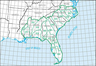
The South Atlantic–Gulf water resource region is one of 21 major geographic areas, or regions, in the first level of classification used by the United States Geological Survey to divide and sub-divide the United States into successively smaller hydrologic units. These geographic areas contain either the drainage area of a major river, or the combined drainage areas of a series of rivers.
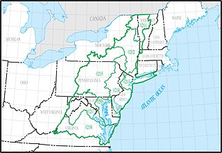
The Mid Atlantic water resource region is one of 21 major geographic areas, or regions, in the first level of classification used by the United States Geological Survey to divide and sub-divide the United States into successively smaller hydrologic units. These geographic areas contain either the drainage area of a major river, or the combined drainage areas of a series of rivers.

The Upper Mississippi water resource region is one of 21 major geographic areas, or regions, in the first level of classification used by the United States Geological Survey to divide and sub-divide the United States into successively smaller hydrologic units. These geographic areas contain either the drainage area of a major river, or the combined drainage areas of a series of rivers.
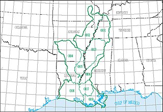
The Lower Mississippi water resource region is one of 21 major geographic areas, or regions, in the first level of classification used by the United States Geological Survey to divide and sub-divide the United States into successively smaller hydrologic units. These geographic areas contain either the drainage area of a major river, or the combined drainage areas of a series of rivers.
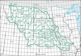
The Missouri water resource region is one of 21 major geographic areas, or regions, in the first level of classification used by the United States Geological Survey to divide and sub-divide the United States into successively smaller hydrologic units. These geographic areas contain either the drainage area of a major river, or the combined drainage areas of a series of rivers.

The Ohio water resource region is one of 21 major geographic areas, or regions, in the first level of classification used by the United States Geological Survey to divide and sub-divide the United States into successively smaller hydrologic units. These geographic areas contain either the drainage area of a major river, or the combined drainage areas of a series of rivers.
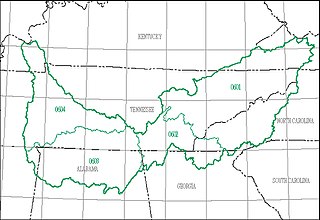
The Tennessee water resource region is one of 21 major geographic areas, or regions, in the first level of classification used by the United States Geological Survey to divide and sub-divide the United States into successively smaller hydrologic units. These geographic areas contain either the drainage area of a major river, or the combined drainage areas of a series of rivers.

The Rio Grande water resource region is one of 21 major geographic areas, or regions, in the first level of classification used by the United States Geological Survey to divide and sub-divide the United States into successively smaller hydrologic units. These geographic areas contain either the drainage area of a major river, or the combined drainage areas of a series of rivers.
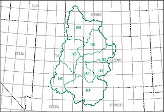
The Upper Colorado water resource region is one of 21 major geographic areas, or regions, in the first level of classification used by the United States Geological Survey to divide and sub-divide the United States into successively smaller hydrologic units. These geographic areas contain either the drainage area of a major river, or the combined drainage areas of a series of rivers.
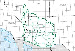
The Lower Colorado water resource region is one of 21 major geographic areas, or regions, in the first level of classification used by the United States Geological Survey to divide and sub-divide the United States into successively smaller hydrologic units. These geographic areas contain either the drainage area of a major river, or the combined drainage areas of a series of rivers.
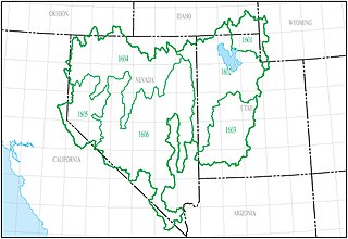
The Great Basin water resource region is one of 21 major geographic areas, or regions, in the first level of classification used by the United States Geological Survey to divide and sub-divide the United States into successively smaller hydrologic units. These geographic areas contain either the drainage area of a major river, or the combined drainage areas of a series of rivers.
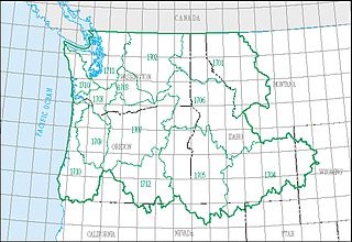
The Pacific Northwest water resource region is one of 21 major geographic areas, or regions, in the first level of classification used by the United States Geological Survey to divide and sub-divide the United States into successively smaller hydrologic units. These geographic areas contain either the drainage area of a major river, or the combined drainage areas of a series of rivers.

The Hawaii water resource region is one of 21 major geographic areas, or regions, in the first level of classification used by the United States Geological Survey to divide and sub-divide the United States into successively smaller hydrologic units. These geographic areas contain either the drainage area of a major river, or the combined drainage areas of a series of rivers.

The Souris–Red–Rainy region is one of 21 major geographic areas, or regions, in the first level of classification used by the United States Geological Survey to divide and sub-divide the United States into successively smaller hydrologic units. These geographic areas contain either the drainage area of a major river, or the combined drainage areas of a series of rivers.
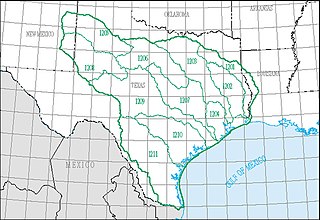
The Texas–Gulf water resource region is one of 21 major geographic areas, or regions, in the first level of classification used by the United States Geological Survey to divide and sub-divide the United States into successively smaller hydrologic units. These geographic areas contain either the drainage area of a major river, or the combined drainage areas of a series of rivers.
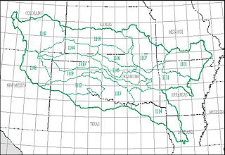
The Arkansas–White–Red water resource region is one of 21 major geographic areas, or regions, in the first level of classification used by the United States Geological Survey to divide and sub-divide the United States into successively smaller hydrologic units. These geographic areas contain either the drainage area of a major river, or the combined drainage areas of a series of rivers.
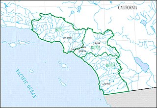
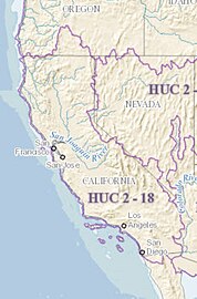
Southern California Coastal water resource subregion is one of 10 hydrologic subregions within the California water resource region and is one of 222 water resource subregions in the United States hydrologic unit system. The Southern California coastal subregion, sometimes called the South Coast Hydrologic Subregion, is a second-level subdivision covering is approximately 11,000 sq mi and extends from Rincon Creek on the north to the international border with Mexico on the south. The South Coast Hydrologic Subregion is composed of three third-level hydrological units. The federally-defined Southern California Coastal water resource subregion equates roughly with the state-designated South Coast hydrologic region. Per a USGS report of 1976, "Water deficiency is prevalent in the South Coastal subregion." By 1955 the region was found to be experiencing measurable levels of saltwater intrusion due to overdrawn aquifers and several wells were abandoned as a consequence. Part of the solution was injecting Colorado River water from the aqueduct into local wells to defend against the salted water, a practice called artificial recharge.

Ventura–San Gabriel Coastal water resource basin is one of three hydrologic basins within the Southern California Coastal water resource subregion and is one of approximately 2,200 water resource basins in the United States hydrologic unit system. The Ventura–San Gabriel Coastal water resource basin is a third-level subdivision of the United States hydrologic unit system.

Northern Mojave–Mono Lake water resource subregion is one of 10 water resource subregions within the California water resource region and is one of 222 water resource subregions in the federally organized United States hydrologic unit system.

Santa Ana water resource basin is one of three hydrologic basins within the Southern California Coastal water resource subregion and is one of approximately 2,200 water resource basins in the United States hydrologic unit system. The Santa Ana water resource basin is a third-level subdivision of the United States hydrologic unit system.


 Region (2-digit code)
 Subregions (4-digit codes)
 Basins (6-digit codes)
 Subbasins (8-digit codes)


