Mid Atlantic water resource region

Last updated

The Mid Atlantic water resource region is one of 21 major geographic areas, or regions, in the first level of classification used by the United States Geological Survey to divide and sub-divide the United States into successively smaller hydrologic units. These geographic areas contain either the drainage area of a major river, or the combined drainage areas of a series of rivers. [1] [2]

Contents

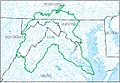
The Mid Atlantic region, which is listed with a 2-digit hydrologic unit code (HUC) of 02, has an approximate size of 106,334 square miles (275,400 square kilometers ), and consists of 8 subregions, which are listed with the 4-digit HUCs 0201 through 0208.

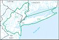
This region includes the drainage within the United States that ultimately discharges into: (a) the Atlantic Ocean within and between the states of New York and Virginia; (b) Long Island Sound south of the New York-Connecticut State Line; and (c) the Riviere Richelieu, a tributary of the St. Lawrence River. It includes all of Delaware and New Jersey and the District of Columbia, and parts of Connecticut, Maryland, Massachusetts, New York, Pennsylvania, Vermont, Virginia, and West Virginia. [3]

The Mid Atlantic region, with its 8 4-digit subregion hydrologic unit boundaries. HUC02.jpg
The Mid Atlantic region, with its 8 4-digit subregion hydrologic unit boundaries.

Listing of water resource subregions

Subregion HUC [4] Subregion Name [4] Subregion Description [3] Subregion Location [4] Subregion Size [4] Subregion Map
0201 Richelieu subregion The Riviere Richelieu Basin, including Lake Champlain drainage, within the United States.Located in New York and Vermont.7,720 sq mi (20,000 km2)
HUC0201 HUC0201.jpg
HUC0201
0202 Upper Hudson subregion The Hudson River Basin to and including the Popolopen Brook Basin just upstream from Bear Mountain Bridge.Located in New Jersey, New York, Massachusetts, and Vermont.12,666 sq mi (32,800 km2)
HUC0202 HUC0202.jpg
HUC0202
0203 Lower Hudson–Long Island subregion The coastal drainage and associated waters from the Byram River Basin boundary, to the Manasquan River Basin boundary, including the Hudson River Basin downstream from the Popolopen Brook Basin boundary, Long Island and Block Island Sounds south of the New York-Connecticut state line, and Long Island.Located in Connecticut, New Jersey, and New York.7,259 sq mi (18,800 km2)
HUC0203 HUC0203.jpg
HUC0203
0204 Delaware–Mid Atlantic Coastal subregion The coastal drainage and associated waters from and including the Manasquan River Basin to and including the Delaware River Basin which includes Delaware Bay.Located in Delaware, Maryland, New Jersey, New York, and Pennsylvania.17,977 sq mi (46,560 km2)
HUC0204 HUC0204.jpg
HUC0204
0205 Susquehanna subregion The Susquehanna River Basin.Located in Maryland, New York, and Pennsylvania.27,500 sq mi (71,000 km2)
HUC0205 HUC0205.jpg
HUC0205
0206 Upper Chesapeake subregion The Chesapeake Bay and its tributary drainage north of the Maryland-Virginia state line including the Pocomoke River drainage, excluding the Susquehanna and Potomac River Basins; and the Coastal drainage from the Delaware Bay drainage boundary to Chincoteague Inlet on the Delmarva Peninsula.Located in Delaware, Maryland, Virginia, and Pennsylvania.5,871 sq mi (15,210 km2)
HUC0206 HUC0206.jpg
HUC0206
0207 Potomac subregion The Potomac River Basin.Located in District of Columbia, Maryland, Pennsylvania, Virginia, and West Virginia.14,679 sq mi (38,020 km2)
HUC0207 HUC0207.jpg
HUC0207
0208 Lower Chesapeake subregion The Chesapeake Bay and its tributary drainage south of the Maryland-Virginia state line excluding the Pocomoke River drainage; and the Coastal drainage from Chincoteague Inlet on the Delmarva Peninsula to the Back Bay drainage boundary.Located in Virginia.20,682 sq mi (53,570 km2)
HUC0208 HUC0208.jpg
HUC0208

See also

Related Research Articles

<span class="mw-page-title-main">South Atlantic–Gulf water resource region</span> Drainage region

The South Atlantic–Gulf water resource region is one of 21 major geographic areas, or regions, in the first level of classification used by the United States Geological Survey to divide and sub-divide the United States into successively smaller hydrologic units. These geographic areas contain either the drainage area of a major river, or the combined drainage areas of a series of rivers.

<span class="mw-page-title-main">New England water resource region</span> US hydrologic region

The New England water resource region is one of 21 major geographic areas, or regions, in the first level of classification used by the United States Geological Survey to divide and sub-divide the United States into successively smaller hydrologic units. These geographic areas contain either the drainage area of a major river, or the combined drainage areas of a series of rivers. The New England region, which is listed with a 2-digit hydrologic unit code (HUC) of 01, has an approximate size of 73,753 square miles, and consists of 11 sub-regions, which are listed with the 4-digit HUCs 0101 through 0111.

<span class="mw-page-title-main">Upper Mississippi water resource region</span>

The Upper Mississippi water resource region is one of 21 major geographic areas, or regions, in the first level of classification used by the United States Geological Survey to divide and sub-divide the United States into successively smaller hydrologic units. These geographic areas contain either the drainage area of a major river, or the combined drainage areas of a series of rivers.

<span class="mw-page-title-main">Lower Mississippi water resource region</span>

The Lower Mississippi water resource region is one of 21 major geographic areas, or regions, in the first level of classification used by the United States Geological Survey to divide and sub-divide the United States into successively smaller hydrologic units. These geographic areas contain either the drainage area of a major river, or the combined drainage areas of a series of rivers.

<span class="mw-page-title-main">Missouri water resource region</span>

The Missouri water resource region is one of 21 major geographic areas, or regions, in the first level of classification used by the United States Geological Survey to divide and sub-divide the United States into successively smaller hydrologic units. These geographic areas contain either the drainage area of a major river, or the combined drainage areas of a series of rivers.

<span class="mw-page-title-main">Great Lakes water resource region</span>

The Great Lakes water resource region is one of 21 major geographic areas, or regions, in the first level of classification used by the United States Geological Survey to divide and sub-divide the United States into successively smaller hydrologic units. These geographic areas contain either the drainage area of a major river, or the combined drainage areas of a series of rivers.

<span class="mw-page-title-main">Ohio water resource region</span>

The Ohio water resource region is one of 21 major geographic areas, or regions, in the first level of classification used by the United States Geological Survey to divide and sub-divide the United States into successively smaller hydrologic units. These geographic areas contain either the drainage area of a major river, or the combined drainage areas of a series of rivers.

<span class="mw-page-title-main">Tennessee water resource region</span>

The Tennessee water resource region is one of 21 major geographic areas, or regions, in the first level of classification used by the United States Geological Survey to divide and sub-divide the United States into successively smaller hydrologic units. These geographic areas contain either the drainage area of a major river, or the combined drainage areas of a series of rivers.

<span class="mw-page-title-main">Rio Grande water resource region</span>

The Rio Grande water resource region is one of 21 major geographic areas, or regions, in the first level of classification used by the United States Geological Survey to divide and sub-divide the United States into successively smaller hydrologic units. These geographic areas contain either the drainage area of a major river, or the combined drainage areas of a series of rivers.

<span class="mw-page-title-main">Upper Colorado water resource region</span> Major geographic area

The Upper Colorado water resource region is one of 21 major geographic areas, or regions, in the first level of classification used by the United States Geological Survey to divide and sub-divide the United States into successively smaller hydrologic units. These geographic areas contain either the drainage area of a major river, or the combined drainage areas of a series of rivers.

<span class="mw-page-title-main">Lower Colorado water resource region</span> Major geographic area

The Lower Colorado water resource region is one of 21 major geographic areas, or regions, in the first level of classification used by the United States Geological Survey to divide and sub-divide the United States into successively smaller hydrologic units. These geographic areas contain either the drainage area of a major river, or the combined drainage areas of a series of rivers.

<span class="mw-page-title-main">Great Basin water resource region</span>

The Great Basin water resource region is one of 21 major geographic areas, or regions, in the first level of classification used by the United States Geological Survey to divide and sub-divide the United States into successively smaller hydrologic units. These geographic areas contain either the drainage area of a major river, or the combined drainage areas of a series of rivers.

<span class="mw-page-title-main">Pacific Northwest water resource region</span>

The Pacific Northwest water resource region is one of 21 major geographic areas, or regions, in the first level of classification used by the United States Geological Survey to divide and sub-divide the United States into successively smaller hydrologic units. These geographic areas contain either the drainage area of a major river, or the combined drainage areas of a series of rivers.

<span class="mw-page-title-main">California water resource region</span> Surface water, first-level USGS hydrologic system subdivision

The California water resource region is one of 21 major geographic areas, or regions, in the first level of classification used by the United States Geological Survey in the United States hydrologic unit system, which is used to divide and sub-divide the United States into successively smaller hydrologic units. These geographic areas contain either the drainage area of a major river, or the combined drainage areas of a series of rivers.

<span class="mw-page-title-main">Alaska water resource region</span>

The Alaska water resource region is one of 21 major geographic areas, or regions, in the first level of classification used by the United States Geological Survey to divide and sub-divide the United States into successively smaller hydrologic units. These geographic areas contain either the drainage area of a major river, or the combined drainage areas of a series of rivers.

<span class="mw-page-title-main">Hawaii water resource region</span>

The Hawaii water resource region is one of 21 major geographic areas, or regions, in the first level of classification used by the United States Geological Survey to divide and sub-divide the United States into successively smaller hydrologic units. These geographic areas contain either the drainage area of a major river, or the combined drainage areas of a series of rivers.

<span class="mw-page-title-main">Caribbean water resource region</span>

The Caribbean water resource region is one of 21 major geographic areas, or regions, in the first level of classification used by the United States Geological Survey to divide and sub-divide the United States into successively smaller hydrologic units. These geographic areas contain either the drainage area of a major river, or the combined drainage areas of a series of rivers.

<span class="mw-page-title-main">Souris–Red–Rainy water resource region</span>

The Souris–Red–Rainy region is one of 21 major geographic areas, or regions, in the first level of classification used by the United States Geological Survey to divide and sub-divide the United States into successively smaller hydrologic units. These geographic areas contain either the drainage area of a major river, or the combined drainage areas of a series of rivers.

<span class="mw-page-title-main">Texas–Gulf water resource region</span>

The Texas–Gulf water resource region is one of 21 major geographic areas, or regions, in the first level of classification used by the United States Geological Survey to divide and sub-divide the United States into successively smaller hydrologic units. These geographic areas contain either the drainage area of a major river, or the combined drainage areas of a series of rivers.

<span class="mw-page-title-main">Arkansas–White–Red water resource region</span>

The Arkansas–White–Red water resource region is one of 21 major geographic areas, or regions, in the first level of classification used by the United States Geological Survey to divide and sub-divide the United States into successively smaller hydrologic units. These geographic areas contain either the drainage area of a major river, or the combined drainage areas of a series of rivers.

References

  1. "Science in Your Watershed - Locate Your Watershed". USGS . Retrieved 2016-10-12.PD-icon.svg This article incorporates text from this source, which is in the public domain .
  2. "Hydrologic Unit Maps". USGS . Retrieved 2016-10-13.PD-icon.svg This article incorporates text from this source, which is in the public domain .
  3. 1 2 "Boundary Descriptions and Names of Regions, Subregions, Accounting Units and Cataloging Units". USGS . Retrieved 2016-10-13.PD-icon.svg This article incorporates text from this source, which is in the public domain .
  4. 1 2 3 4 McManamay RA, Bevelhimer MS, Kao SC, Yaxing W, Martinez-Gonzalez M, Samu N (2013). "National Hydropower Asset Assessment Environmental Attribution". USGS-Oak Ridge National Laboratory . Retrieved 2016-10-13.PD-icon.svg This article incorporates text from this source, which is in the public domain .