| New England water resource region | |
|---|---|
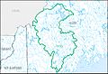
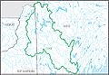
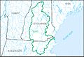
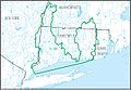
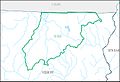
 The New England region, with its 11 4-digit sub-region hydrologic unit boundaries. | |
| Location | |
| Countries | Canada, United States |
| States | Includes all of Maine, New Hampshire and Rhode Island, and parts of Connecticut, Massachusetts, New York, and Vermont |
| Physical characteristics | |
| Basin size | 73,753 sq mi (191,020 km2) |
The New England water resource region is one of 21 major geographic areas, or regions, in the first level of classification used by the United States Geological Survey to divide and sub-divide the United States into successively smaller hydrologic units. These geographic areas contain either the drainage area of a major river, or the combined drainage areas of a series of rivers. [1] [2] The New England region, which is listed with a 2-digit hydrologic unit code (HUC) of 01, has an approximate size of 73,753 square miles (191,020 square kilometers ), and consists of 11 sub-regions, which are listed with the 4-digit HUCs 0101 through 0111.
Contents
This region includes the drainage within the United States that ultimately discharges into: (a) the Bay of Fundy; (b) the Atlantic Ocean within and between the states of Maine and Connecticut; (c) Long Island Sound north of the New York-Connecticut state line; and (d) the Riviere St. Francois, a tributary of the Saint Lawrence River. The region includes all of Maine, New Hampshire and Rhode Island, and parts of Connecticut, Massachusetts, New York, and Vermont. [3]