Dartmoor is an upland area in southern Devon, South West England. The moorland and surrounding land has been protected by National Park status since 1951. Dartmoor National Park covers 954 km2 (368 sq mi).
A tor, which is also known by geomorphologists as either a castle koppie or kopje, is a large, free-standing rock outcrop that rises abruptly from the surrounding smooth and gentle slopes of a rounded hill summit or ridge crest. In the South West of England, the term is commonly also used for the hills themselves – particularly the high points of Dartmoor in Devon and Bodmin Moor in Cornwall.
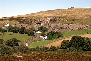
Merrivale is a locality in western Dartmoor, in the West Devon district of Devon, England. It is best known for the nearby series of Bronze Age megalithic monuments to the south and a former granite quarry.

High Willhays, or according to some authorities High Willes, is the highest point on Dartmoor, Devon, at 621 metres above sea level, and the highest point in Southern England.

Jay's Grave is supposedly the last resting place of a suicide victim who is thought to have died in the late 18th century. It has become a well-known landmark on Dartmoor, Devon, in South-West England, and is the subject of local folklore, and several ghost stories.

The Dartmoor longhouse is a type of traditional stone-built home, typically found on the high ground of Dartmoor, in Devon, England and belonging to a wider tradition of combining human residences with those of livestock under a single roof specific to western Britain; Wales, Cornwall and Devon, where they are more usually referred to simply as longhouses and in general housebarns.

Bowerman's Nose is a stack of weathered granite on Dartmoor, Devon, England. It is situated on the northern slopes of Hayne Down, about a mile from Hound Tor and close to the village of Manaton at grid reference SX742805. It is about 21.5 feet (6.6 m) high and is the hard granite core of a former tor, standing above a 'clitter' of the blocks that have eroded and fallen from it.

Hound Tor is a tor on Dartmoor, Devon, England and is a good example of a heavily weathered granite outcrop. It is easily accessible, situated within a few minutes from the B3387 between Bovey Tracey and Widecombe-in-the-Moor.
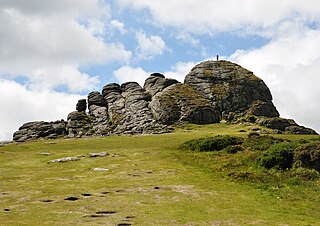
Haytor, also known as Haytor Rocks, Hay Tor, or occasionally Hey Tor, is a granite tor on the eastern edge of Dartmoor in the English county of Devon.

Crockern Tor is a tor in Dartmoor National Park, Devon, England. Composed of two large outcrops of rock, it is 396 metres above sea level. The lower outcrop was the open-air meeting place of the Stannary Convocation of Devon from the early 14th century until the first half of the 18th century. On Parliament Rock, pictured here, the Lord Warden of the Great Court of the Devon Tinners supposedly sat during meetings of the Court.
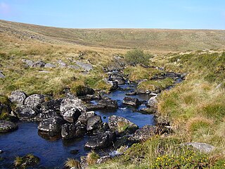
The West Dart River is one of the two main tributaries of the River Dart in Devon, England.

Whiteworks is a former mining hamlet near the town of Princetown, within Dartmoor National Park, in the English county of Devon. Tin mining is central to the history of settlement at Whiteworks, which was once home to one of Dartmoor's largest tin mines. The original cottages and their inhabitants were related to this industry, until the area became used increasingly for farming in the 20th century. The site has now largely been abandoned, although Whiteworks is still on the route of many walks including Abbots Way Walk passes 500 m to the west.
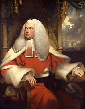
Sir Francis Buller, 1st Baronet was an English judge.

Bellever is a hamlet in Dartmoor, Devon, England. It is located on the river East Dart about 2 kilometres (1 mi) south of Postbridge.

Wistman's Wood is one of three remote high-altitude oakwoods on Dartmoor in Devon, England.
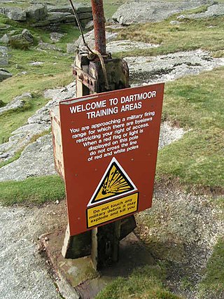
The Dartmoor Training Area (DTA) is a military training area on Dartmoor in Devon in southwest England. The area consists of approximately 13,000 hectares in the Dartmoor National Park.

Cosdon Hill, also called Cosdon Beacon, or Cawsand Beacon, is one of the highest hills on Dartmoor, in Devon, England. It has numerous traces of prehistoric occupation.

The Cherry Brook is a tributary of the West Dart River on Dartmoor, Devon, England.
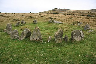
The Nine Maidens, also known as the Seventeen Brothers, is a Bronze Age stone circle located near the village of Belstone on Dartmoor in Devon, England. The stone circle functioned as a burial chamber, although the cairn has since been robbed and the cist, known locally as a kistvaen, destroyed.