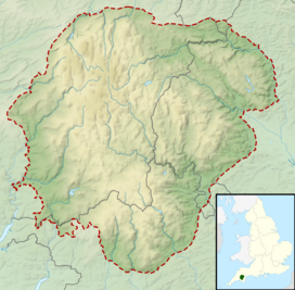
Dartmoor is an upland area in southern Devon, South West England. The moorland and surrounding land has been protected by National Park status since 1951. Dartmoor National Park covers 954 km2 (368 sq mi).

The industrial archaeology of Dartmoor covers a number of the industries which have, over the ages, taken place on Dartmoor, and the remaining evidence surrounding them. Currently only three industries are economically significant, yet all three will inevitably leave their own traces on the moor: china clay mining, farming and tourism.
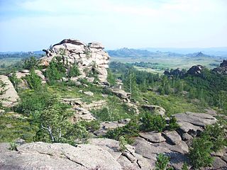
A tor, which is also known by geomorphologists as either a castle koppie or kopje, is a large, free-standing rock outcrop that rises abruptly from the surrounding smooth and gentle slopes of a rounded hill summit or ridge crest. In the South West of England, the term is commonly also used for the hills themselves – particularly the high points of Dartmoor in Devon and Bodmin Moor in Cornwall.

The Walkham is a river whose source is on Dartmoor, Devon, England. It rises in the wide gap between Roos Tor and Great Mis Tor and flows almost due south for approximately 3 miles (4.8 km) leaving the tors and thus National Park behind then south-west for 1 mile (1.6 km) past Woodtown. The river then reaches a village, Horrabridge, with a small compact network of streets mainly on the south or left bank. It receives most of its tributaries which are unnamed headwaters along its south-flowing inception, draining the near side of two series of six tors (peaks) to the west ending in Pew Tor at 320 metres and likewise to the east ending in Leeden Tor at 389 metres. In absolute distance, 2 miles (3.2 km) west of the village and the same south of the small well-preserved town of Tavistock by a footbridge on the West Devon Way the Walkham joins the Tavy which discharges into the Tamar Estuary north of the Plymouth conurbation after a fast descent around wide hillsides, a few miles south.

A tor enclosure is a prehistoric monument found in the southwestern part of Great Britain. These monuments emerged around 4000 BCE in the early Neolithic.
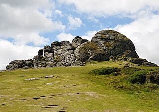
Haytor, also known as Haytor Rocks, Hay Tor, or occasionally Hey Tor, is a granite tor on the eastern edge of Dartmoor in the English county of Devon.
Ashburn is a river in the Dartmoor moors in Devon in south-west England, flowing through the Ashburton valley to the River Dart.
The West Dart River is one of the two main tributaries of the River Dart in Devon, England.

Whiteworks is a former mining hamlet near the town of Princetown, within Dartmoor National Park, in the English county of Devon. Tin mining is central to the history of settlement at Whiteworks, which was once home to one of Dartmoor's largest tin mines. The original cottages and their inhabitants were related to this industry, until the area became used increasingly for farming in the 20th century. The site has now largely been abandoned, although Whiteworks is still on the route of many walks including Abbots Way Walk passes 500 m to the west.

Great Links Tor is a prominent tor on the north-western flank of Dartmoor, Devon, England. It is visible for a considerable distance on the approach to the moor from the west. It is one of the highest points on Dartmoor, standing 1,939 feet (591 m) above sea level and is dominated by a monolithic outcropping of granite some 40 feet (12 m) high. There is an OS Triangulation point on a block to the west of the main outcrop, which is where most who visit the tor will climb to. The highest outcrop is inaccessible without a climb, the easiest route being up the eastern chimely. Other routes can be found here. Close by are the remains of the Rattlebrook Peat Works at Rattlebrook Head and the ruins of the appropriately named 'Bleak House'.

Berra Tor is a granite tor on the south western edge of Dartmoor. It is only 132 metres above sea level so is one of the lowest tors on Dartmoor. It is quite isolated and hidden from everywhere else and is generally quite unknown. It juts out of some trees and resembles more of a rock than an outcrop on a hill, like Great Mis Tor and Yes Tor that also provide views. Its nearest settlement of size is Buckland Monachorum.
Sharp Tor is a common name given to tors (outcrops), particularly on Dartmoor and Bodmin Moor. All the "Sharp Tors" are listed below with their location and height:
Rippon Tor is a striking tor on eastern Dartmoor, in England, that stands at 473 metres (1,552 ft) above sea level. It has three cairns, of which are some of Dartmoor's largest, a triangulation pillar, and several rock piles that overlook the northern high moors near Fernworthy Forest and Great Mis Tor. Field boundaries surround the tor.
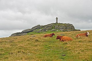
Brat Tor, also known as Brai Tor and Widgery Tor, is a dramatic granite tor on the western flank of Dartmoor, England. It is best known for Widgery Cross, the tallest Dartmoor cross, which stands on its summit. It is, however, not as grand as other neighbouring tors, such as the imposing Great Links Tor and Hare Tor. It stands at 454 metres above sea level.

Chinkwell Tor is a granite tor on Dartmoor, England. It consists of two cairns at the summit which stand at 458 metres above sea level It is surrounded by other tors and features such as:
Easdon Tor is a granite tor on Dartmoor, in southwest England. It stands at 439 metres above sea level and the highest point is marked with a triangulation pillar. It lies in a popular tourist destination, overlooking the popular tors of Houndtor and Haytor, though this tor is quieter than them. To the west lies Hameldown Beacon ridge and to the northwest Cosdon Beacon.

Greator Rocks, Greater, or Grea Tor, is a dramatic granite tor on Dartmoor, England. It is a common climbing tor, like nearby Hound Tor. It is 371m above sea level.
Combestone Tor is a granite tor on Dartmoor, England. It is 356 metres (1,168 ft) above sea level. The tor is considered a popular destination for tourists.
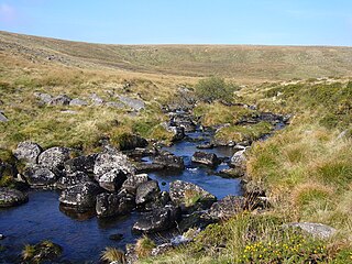
Rattle Brook is a brook in north Dartmoor in Devon in south-west England. It is situated East of Great Links Tor, and rises by the Rattlebrook Peatworks on remote moorland in the western section of Dartmoor National Park. It flows past Bleak House with Green Tor to the east and Higher and Lower Dunna Goat Tors to the west. It runs between Amicombe Hill and Rattlebrook Hill to join the River Tavy at the mouth of Tavy Cleave.