
North Yorkshire is the largest non-metropolitan county and lieutenancy area in England, covering an area of 8,654 square kilometres (3,341 sq mi). Around 40% of the county is covered by national parks, including most of the Yorkshire Dales and the North York Moors. It is one of four counties in England to hold the name Yorkshire; the three other counties are the East Riding of Yorkshire, South Yorkshire and West Yorkshire.

Ledsham is a village and civil parish 4 miles (6 km) north of Castleford and 11 miles (18 km) east of Leeds in the county of West Yorkshire, England. The village is in the City of Leeds metropolitan borough and near to the A1 Great North Road. It has a population of 162, increasing to 181 at the 2011 Census.

The Borough of Fylde is a local government district with borough status in Lancashire, England. It covers part of the Fylde plain, after which it is named. The council's headquarters are in St Annes. Some council departments, including Planning and an office of the Registrar, were previously located in Wesham, but in 2007 these offices were transferred to the ownership of the NHS North Lancashire Primary Care Trust and have since been replaced by a new housing development. The population of the Non-metropolitan district at the 2011 census was 75,757.

Selby District is a local government district of North Yorkshire, England. The local authority, Selby District Council, is based in the town of Selby and provides services to an area which includes Tadcaster and a host of villages. The Local Authority had a population of 83,449 at the 2011 Census. It is the southernmost district of North Yorkshire, and it borders the City of York, a unitary authority, the districts of the City of Leeds and the City of Wakefield, in West Yorkshire, the town of Doncaster, in South Yorkshire, the ceremonial county of the East Riding of Yorkshire, and the Borough of Harrogate.

The Borough of Harrogate is a local government district and borough of North Yorkshire, England. Its population at the census of 2011 was 157,869. Its council is based in the town of Harrogate, but it also includes surrounding towns and villages. This includes the cathedral city of Ripon and almost all of the Nidderdale Area of Outstanding Natural Beauty.

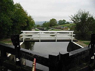
The Borough of Burnley is a local government district of Lancashire, England, with the status of a non-metropolitan district and borough. It has an area of 42.7 square miles (110.7 km2) and a population of 88,920 (mid-2019 est.), and is named after its largest town, Burnley. The borough is bounded by Hyndburn, Ribble Valley, Pendle, Rossendale – all in Lancashire – and the borough of Calderdale in West Yorkshire. It is governed by Burnley Borough Council, which is currently under no overall control following the 2019 local elections.

A civil parish is a country subdivision, forming the lowest unit of local government in England. There are 94 civil parishes in the ceremonial county of South Yorkshire, most of the county being unparished. At the 2001 census, there were 360,191 people living in the parishes, increasing to 369,220 in 2011, accounting for 27.5 per cent of the county's population.

Aberford is a large village and civil parish on the eastern outskirts of the City of Leeds metropolitan borough in West Yorkshire, England. It had a population of 1,059 according to the 2001 census, increasing to 1,180 at the 2011 Census. It is situated 10 miles (15.5 km) east, north east of Leeds city centre and lies in the LS25 Leeds postcode area.
Bank Newton is a small settlement and civil parish in the Craven district of North Yorkshire, England. According to the 2001 census the parish had a population of 47, and at the 2011 census the population of the civil parish remained less than 100 and therefore its details were included in the civil parish of Gargrave. In 2015, North Yorkshire County Council estimated the population of the parish to be 50.
Barlby with Osgodby is a civil parish in the Selby district of North Yorkshire, England, just to the north of Selby.

Great Preston is a small rural village in the City of Leeds metropolitan borough, West Yorkshire, England. It has incorporated the once neighbouring hamlet of Little Preston.

Haighton is a civil parish in the City of Preston, Lancashire, England. It is a rural area north east of the urban city of Preston, beyond Fulwood and Brookfield.

Preston Rural North is an electoral ward in the City of Preston, Lancashire, England. The ward is the largest by area in the city, containing the smaller and smallest villages from the northern areas of Preston, from Woodplumpton bordering the M55 motorway junction at Broughton, to Beacon Fell at the border of the borough of Wyre.

Preston Rural East is an electoral ward in the City of Preston, Lancashire, England. The ward is in the eastern and northeastern part of the city near the M55 motorway moving out towards Sherwood and Grimsargh. The population of the ward at the 2011 census was 4,577.

The Milton Keynes urban area or Milton Keynes Built-up Area is a designation established by the United Kingdom's Office for National Statistics. As with other urban areas, it includes settlements that are physically contiguous with the rest of the built up area but, for historical reasons, regard themselves as being outside of the principal settlement: this urban area includes Newport Pagnell and Woburn Sands.
Stainborough is a civil parish in the Metropolitan Borough of Barnsley in South Yorkshire, England. At the 2001 census it had a population of 399, reducing slightly to 390 at the 2011 Census.
Heck is a civil parish in the English county of North Yorkshire. The population of this civil parish at the census 2011 was 201, a slight drop on the 2001 census figure of 209.

The City of Preston is a city and non-metropolitan district in Lancashire, England. On the north bank of the River Ribble, it was granted city status in 2002, becoming England's 50th city in the 50th year of Queen Elizabeth II's reign. The City of Preston district has a population of 143,135 (mid-2019 est.), and lies at the centre of the Central Lancashire sub-region, with a population of 335,000.

Preston Richard is a civil parish in South Lakeland, Cumbria, England. It includes the village of Endmoor, and the hamlets of Crooklands, Birkrigg Park, Milton, Low Park, and Summerlands.
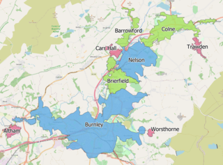
The Burnley Built-up area is an urban area or conurbation which extends from the town of Burnley to Padiham, Brierfield, Nelson, Barrowford and Colne in Lancashire, England. The area takes in parts of the boroughs of Burnley and Pendle, and also small parts of Hyndburn and Ribble Valley. It also includes a number of villages such as Blacko, Trawden and Worsthorne. In 2011 the area was recorded at having a population of 149,422. It is the third most populous urban area in Lancashire after Preston and Blackpool, with slightly more people than the urban areas of Cambridge or York.
