A tor, which is also known by geomorphologists as either a castle koppie or kopje, is a large, free-standing rock outcrop that rises abruptly from the surrounding smooth and gentle slopes of a rounded hill summit or ridge crest. In the South West of England, the term is commonly also used for the hills themselves – particularly the high points of Dartmoor in Devon and Bodmin Moor in Cornwall.
Rock climbing is a popular activity in the Peak District; particularly on edges such as Stanage or Froggatt. Generally the climbing style is free climbing and the rock is either gritstone or limestone. Climbing has been practised in the Peak District since the late 19th century; James W. Puttrell is generally credited with starting the sport. The first climbing guidebook to the area was Some Gritstone Climbs, by John Laycock, published in 1913. There are over 10,000 routes in the Peak District. One of the most famous Peak District climbers, and a pioneer of many new routes, is Ron Fawcett. The climb known as "Master's Edge", on Millstone Edge, near Hathersage, is a testament to his skill and strength. The climb is graded E7 6c and rises 19m up the near vertical edge.

Glastonbury Tor is a tor near Glastonbury in the English county of Somerset, topped by the roofless St Michael's Tower, a Grade I listed building. The site is managed by the National Trust and has been designated a scheduled monument. The Tor is mentioned in Celtic mythology, particularly in myths linked to King Arthur, and has several other enduring mythological and spiritual associations.

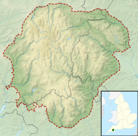
Mam Tor is a 517 m (1,696 ft) hill near Castleton in the High Peak of Derbyshire, England. Its name means "mother hill", so called because frequent landslips on its eastern face have resulted in a multitude of "mini-hills" beneath it. These landslips, which are caused by unstable lower layers of shale, also give the hill its alternative name of Shivering Mountain.

The Walkham is a river whose source is on Dartmoor, Devon, England. It rises in the wide gap between Roos Tor and Great Mis Tor and flows almost due south for approximately 3 miles (4.8 km) leaving the tors and thus National Park behind then south-west for 1 mile (1.6 km) past Woodtown. The river then reaches a village, Horrabridge, with a small compact network of streets mainly on the south or left bank. It receives most of its tributaries which are unnamed headwaters along its south-flowing inception, draining the near side of two series of six tors (peaks) to the west ending in Pew Tor at 320 metres and likewise to the east ending in Leeden Tor at 389 metres. In absolute distance, 2 miles (3.2 km) west of the village and the same south of the small well-preserved town of Tavistock by a footbridge on the West Devon Way the Walkham joins the Tavy which discharges into the Tamar Estuary north of the Plymouth conurbation after a fast descent around wide hillsides, a few miles south.

A tor enclosure is a prehistoric monument found in the southwestern part of Great Britain. These monuments emerged around 4000 BCE in the early Neolithic.

Ringing rocks, also known as sonorous rocks or lithophonic rocks, are rocks that resonate like a bell when struck. Examples include the Musical Stones of Skiddaw in the English Lake District; the stones in Ringing Rocks Park, in Upper Black Eddy, Bucks County, Pennsylvania; the Ringing Rocks of Kiandra, New South Wales; and the Bell Rock Range of Western Australia. Ringing rocks are used in idiophonic musical instruments called lithophones.
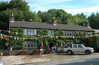
Birchover is a village and civil parish in the Peak District National Park in Derbyshire, England, five miles north-west of Matlock. At the 2001 Census, it had a population of 362. Eagle Tor is a small hamlet on the north western edge of the parish.
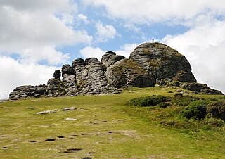
Haytor, also known as Haytor Rocks, Hay Tor, or occasionally Hey Tor, is a granite tor on the eastern edge of Dartmoor in the English county of Devon.
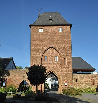
Nideggen is a town in the district of Düren in the state of North Rhine-Westphalia, Germany. It is located on the river Rur, in the Eifel hills, approx. 15 km south of Düren.

The Windgather Rocks is a gritstone crag on the Derbyshire–Cheshire border in England. It is in the Peak District National Park and is a popular site for learning the rudiments of rock climbing. As the name suggests the area is exposed to the prevailing westerly winds. The rocks lie above Taxal Edge and are part of a north–south ridge that starts between Kettleshulme and Whaley Bridge and culminates at Shining Tor. The crag was featured in the first guide to rock climbing in the Peak District, Some Gritstone Climbs, published in 1913 and written by John Laycock.
Jason Harbour is a bay 1 mile (1.6 km) wide, lying west of Allen Bay in the north side of Cumberland West Bay, South Georgia. It was charted and named by the Swedish Antarctic Expedition, 1901–04, under Otto Nordenskiöld. The bay was previously visited by the Jason, Captain C.A. Larsen, in 1894.

The Norwegian Handball Federation is the national handball association in Norway.

The Western Rocks are a group of uninhabited skerries and rocks in the south–western part of the Isles of Scilly, United Kingdom, and are renowned for the numerous shipwrecks in the area and the nearby Bishop Rock lighthouse. In 1971, the rocks and islands were designated a Site of Special Scientific Interest for their breeding sea birds. Landing on the islands is both difficult and discouraged and there are few published records of visits by naturalists.

The Große Teufelsmühle is a natural monument on the Viktorshöhe near Friedrichsbrunn in the Harz Mountains of central Germany. The name means "Great Devil's Mill". It is a tor, a granite rock formation that displays typical spheroidal or "mattress" weathering. The Große Teufelsmühle is a protected monument. Next to it is a checkpoint in the Harzer Wandernadel hiking system. In the vicinity is another rock formation, the Kleine Teufelsmühle.
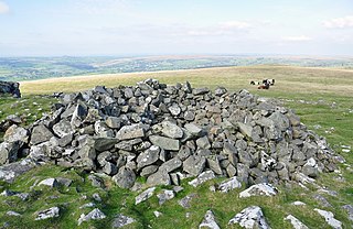
A tor cairn is a prehistoric cult site occurring in the British Isles, especially in Cornwall and Devon but also in Wales. It consists of a circular enclosure of stones or a platform of loose rocks surrounding a natural tor, sometimes encircled by a ditch. The diameter of the roughly 35 tor cairns ranges from 12 to over 30 metres and their height varies from 0.5 to 4.0 metres. There is usually an entrance to the enclosed area and pits in the ground between the rock outcrop (tor) itself and the enclosure.

Chinkwell Tor is a granite tor on Dartmoor, England. It consists of two cairns at the summit which stand at 458 metres above sea level It is surrounded by other tors and features such as:

Chee Dale is a steep-sided gorge on the River Wye near Buxton, Derbyshire, in the Peak District of England.
Torguard is a VPN and proxy software producer which also sells private email service.