Greenbank, Washington

Last updated

Greenbank, Washington
Greenbank Farm, Whidbey Island (front view).jpg
Greenbank Farm
USA Washington location map.svg
Red pog.svg
Greenbank
Usa edcp location map.svg
Red pog.svg
Greenbank
Coordinates: 48°05′53″N122°34′18″W / 48.09806°N 122.57167°W / 48.09806; -122.57167
Country United States
State Washington
County Island
Elevation
60 ft (20 m)
Time zone UTC-8 (Pacific (PST))
  Summer (DST) UTC-7 (PDT)
ZIP
98253
Area code 360
Telephone exchanges222, 678
FIPS code 53-04790 [1]
GNIS feature ID1505281 [2]
An antique tractor at Greenbank Greenbank farm whidbey wa.jpeg
An antique tractor at Greenbank

Greenbank is an unincorporated community on Whidbey Island in Island County, Washington, United States.

Greenbank, which was named by Calvin Philips after his homestead in Delaware, [3] has a population around 1626. It is the location of the Greenbank Farm, once the largest loganberry farm in the world, [4] and the Greenbank Store, which was once owned and run by the Coupe family, descendants of Captain Thomas Coupe, founder of Coupeville and is now owned and run by new owners unrelated to the Coupe family. Opening in 1904, Greenbank Store features access to the post office and a small grocery store, as well as other amenities.

Greenbank Farm, once the largest loganberry farm in the country, now has fields of trails and an off-leash dog area. The farm was saved from development when the Port of Coupeville agreed to purchase the 151-acre property and take on a 20-year bond payment in 1997. The purchase was completed in 2017 and continues to be operated by the Port of Coupeville.

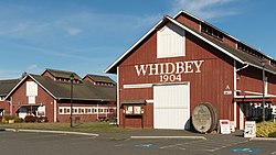
Greenbank Farm with its large historic, “Whidbey 1904 Barn” is a popular venue for weddings, social gatherings and seasonal markets. The Shops at Greenbank Farm, independent tenants of the Port of Coupeville, are located here as well.

Behind the barns at the Greenbank Farm is a small marsh with a viewing platform recently built by the Whidbey Audubon Society. Many species of birds can be observed here including Red Wing Black-Birds and Warblers. Several solar projects have been implemented to reduce impact on the environment as well as offer free EV charging for all visitors.

Greenbank is served by State Route 525, on which several places to stay and other businesses are located.

Points of interest

48°05′53″N122°34′18″W / 48.09806°N 122.57167°W / 48.09806; -122.57167

Related Research Articles

<span class="mw-page-title-main">Whidbey Island</span> Island in Puget Sound in Washington, United States

Whidbey Island is the largest of the islands composing Island County, Washington, in the United States, and the largest island in Washington state. Whidbey is about 30 miles (48 km) north of Seattle, and lies between the Olympic Peninsula and the I-5 corridor of western Washington. The island forms the northern boundary of Puget Sound. It is home to Naval Air Station Whidbey Island. The state parks and natural forests are home to numerous old growth trees.

<span class="mw-page-title-main">Island County, Washington</span> County in Washington, United States

Island County is a county located in the U.S. state of Washington. As of the 2020 census, its population was 86,857. Its county seat is Coupeville, while its largest city is Oak Harbor.

<span class="mw-page-title-main">Coupeville, Washington</span> Town in Washington, United States

Coupeville is a town on Whidbey Island, in Island County, Washington, United States.

<span class="mw-page-title-main">Freeland, Washington</span> Census-designated place in Washington, United States

Freeland is an unincorporated community and census-designated place (CDP) on Whidbey Island in Island County, Washington, United States. At the time of the 2010 census the population was 7,812. The town received its name based on its origins as a socialist commune in the early 1900s: in the eyes of its founders, the land of the town was literally to be free for all people. Some of the first settlers were veterans of a prior experiment in socialism, the nearby Equality Colony.

<span class="mw-page-title-main">Langley, Washington</span> City in Washington, United States

Langley is a city in Island County, Washington, United States. It sits near the south end of Whidbey Island, overlooking the Saratoga Passage. It is the third largest incorporated area on Whidbey. The population was 1,035 at the 2010 census, while the ZCTA for Langley's post office had a population of 4,878. The geographical area of the city is only 0.8 square miles (2.1 km2) but the ZCTA covers 26.20 square miles (67.9 km2).

<span class="mw-page-title-main">Marrowstone, Washington</span> CDP in Washington, United States

Marrowstone is a census-designated place (CDP) in Jefferson County, Washington, United States. The population was 844 at the 2010 census. All Marrowstone addresses are in Nordland, Washington, and the ZIP code for Marrowstone Island is 98358.

<span class="mw-page-title-main">Port Townsend, Washington</span> City in Washington, United States

Port Townsend is a city on the Quimper Peninsula in Jefferson County, Washington, United States. The population was 10,148 at the 2020 United States Census. It is the county seat and only incorporated city of Jefferson County. In addition to its natural scenery at the northeast tip of the Olympic Peninsula, the city is known for the many Victorian buildings remaining from its late 19th-century heyday, numerous annual cultural events, and as a maritime center for independent boatbuilders and related industries and crafts. The Port Townsend Historic District is a U.S. National Historic Landmark District. It is also significantly drier than the surrounding region due to being in the rainshadow of the Olympic Mountains, receiving only 19 inches or 480 millimeters of rain per year.

<span class="mw-page-title-main">Naval Air Station Whidbey Island</span> U.S. Navy airbase in Washington state

Naval Air Station Whidbey Island (NASWI) is a naval air station of the United States Navy located on two pieces of land near Oak Harbor, on Whidbey Island, in Island County, Washington.

Bayview is an unincorporated community centered at the intersection of State Route 525 and Bayview Road on Whidbey Island in Island County, Washington, United States.

San de Fuca is an unincorporated community and geographical location on Whidbey Island in Island County, Washington, United States. Formerly a small town in the 19th century, it lies on the north side of Penn Cove across from Coupeville.

<span class="mw-page-title-main">Granville O. Haller</span>

Granville Owen Haller was a noted Indian fighter, United States Army officer, and wealthy postbellum businessman who settled in northwest Washington state. During the American Civil War, he was charged with the defense of south-central Pennsylvania during the early days of Gettysburg Campaign prior to the arrival of the Army of the Potomac.

<span class="mw-page-title-main">Ebey's Landing National Historical Reserve</span> United States historic place

Ebey's Landing National Historical Reserve is a unit of the National Park Service on Whidbey Island in the Puget Sound, near Coupeville in Island County, Washington, United States.

<span class="mw-page-title-main">Washington's 2nd congressional district</span> U.S. House district for Washington

Washington's 2nd congressional district includes all of Island, San Juan, Skagit, and Whatcom counties, as well as western Snohomish County. It stretches from Bellingham and the Canada–US border in the north to Lynnwood and the King/Snohomish county line in the south. Since 2001, it has been represented by Democrat Rick Larsen.

<span class="mw-page-title-main">Island Transit (Washington)</span> Local public transit operator in Island County, Washington

Island Transit is a zero-fare transit system in Island County, Washington, serving Whidbey Island and Camano Island. The system consists of fixed-route bus service, paratransit, and vanpools, and carried a total of 974,899 passengers in 2015. There is no Sunday or holiday service on Island Transit routes.

<span class="mw-page-title-main">Ferry House (Ebey's Landing)</span> Building in Washington, United States of America

One of the oldest residential buildings in Washington, the Ferry House was built in 1860 by Winfield Scott Ebey as an inn to provide financial stability for his brother's children, who were orphaned when Isacc Neff Ebey was assassinated by northern indigenous tribes. Once completed and opened for business, the building was named The Ebey Inn. The prime location across Admiralty Inlet from Port Townsend meant a steady flow of travelers and income for the three Ebey children. With no other nearby accommodations, the Inn — which housed a post office, a tavern, and rooms for overnight guests — quickly became an important place for sailors and other travelers to rest before continuing their journeys to Coupeville, Whidbey Island, La Conner, Washington, and points further north. Travelers and locals could also purchase merchandise and groceries at the Inn, which served ferry traffic to and from Port Townsend until a new ferry dock was constructed near Fort Casey at the turn of the 20th century. The house stayed in the Ebey family for 57 years, until Isaac Ebey's grandson sold the old Inn in 1917.

<span class="mw-page-title-main">Thomas Coupe</span> Canadian-born American 19th century sailor

Captain Thomas Coupe was a ship's captain and early settler of Whidbey Island.

<span class="mw-page-title-main">Glacial erratic boulders of Island County, Washington</span>

Glacial erratic boulders in Island County are a remnant of the Pleistocene glaciation that created Puget Sound and transformed the surfaces of what are now Island County's main landmasses: Whidbey Island and Camano Island. South of Deception Pass, the two islands' surfaces and beaches are completely composed of glacial till. Abundant glacial erratic boulders lie on the islands, their beaches, and under the near-shore waters.

<span class="mw-page-title-main">Greenbank Farm</span>

Greenbank Farm is a tourist attraction and community farm in the area of Greenbank on Whidbey Island, run by the Port of Coupeville. Founded in 1904 the farm developed until 1940 when it was sold to a loganberry farmer. By 1970 the farm was the largest Loganberry farm in the United States. In 1977, the farm was sold to community governments to save it from being developed for residential use. Today, the farm leases land to local farmers, acts as a tourist attraction, Island meeting place hosting events, and hosts several small businesses. Its location is on one of the thinnest parts of Whidbey, giving a unique vantage point from its walking trails. To Whidbey residents, it is the divider between the North and South Whidbey.

References

  1. "U.S. Census website". United States Census Bureau . Retrieved January 31, 2008.
  2. "Greenbank". Geographic Names Information System . United States Geological Survey, United States Department of the Interior.
  3. Meany, Edmond S. (1923). Origin of Washington geographic names. Seattle: University of Washington Press. p. 103.
  4. Cicero, Providence (May 5, 2012). "For food lovers Whidbey has it all, from farms to cozy cafes and elegant restaurants". The Seattle Times. Retrieved May 6, 2012.