Jerilderie is a small, rural town in the Riverina region of New South Wales, Australia. It is part of the Murrumbidgee Council Local Government Area. At the 2021 census, Jerilderie had a population of 922 people.

Bulla is a locality and township in Melbourne, Victoria, Australia, 23 kilometres (14 mi) north-west of Melbourne's Central Business District, located within the City of Hume local government area. Bulla recorded a population of 668 at the 2021 census.

Kangaroo Ground is a town in Victoria, Australia, 26 km north-east of Melbourne's Central Business District, located within the Shire of Nillumbik local government area. Kangaroo Ground recorded a population of 1,208 at the 2021 census.

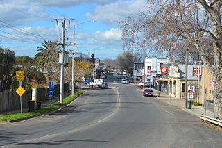
Kyneton is a town in the Macedon Ranges region of central Victoria, Australia. The Calder Freeway bypasses Kyneton to the north and east.

Winchelsea is a town in Victoria, Australia. The town is located in the Surf Coast Shire local government area, the suburb or locality of Winchelsea is predominantly within Surf Coast Shire with a small section within the Colac Otway Shire. Winchelsea is located on the Barwon River 115 km south-west of Melbourne and close to Geelong.
Bacchus Marsh is a town in Victoria, Australia located approximately 50 kilometres (30 mi) north-west of the state capital Melbourne, at a near equidistance to the major cities of Melbourne, Ballarat and Geelong.
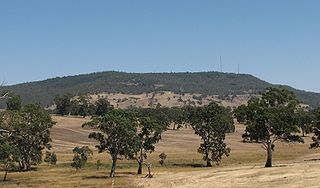
Mount Alexander is a mountain located approximately 125 km north-west of Melbourne, near the town of Harcourt. It rises 350 metres above the surrounding area to a level of 744 metres above sea level. Being a prominent local landmark, the mountain has its name associated with the surrounding district once known as the Mount Alexander goldfields, and presently defined as the Shire of Mount Alexander, centred on Castlemaine. Most of the mountain is included within the boundaries of the Mount Alexander Regional Park managed by Parks Victoria. The Djadjawurrung name for the mountain is Lanjanuc.

Bursledon Windmill is a Grade II* listed windmill in Bursledon, Hampshire, England which has been restored to working order.
The Deniliquin railway line is a broad-gauge railway line serving north-western Victoria, Australia. The line runs from the New South Wales town of Deniliquin into Bendigo, before turning south-south-east towards Melbourne, terminating in Docklands near the central business district. It is a major trunk line both for passenger and freight trains, with many lines branching off from it.

Stembridge Tower Mill in High Ham, Somerset, England, is the last remaining thatched windmill in England. The mill is a grade II* listed building.

Mount Macedon is a town 64 kilometres (40 mi) north-west of Melbourne in the Australian state of Victoria. The town is located below the mountain of the same name, which rises to 1,001 metres (3,284 ft) AHD. At the 2016 census, Mount Macedon had a population of 1,335 and is best known for its collection of 19th-century gardens and associated extravagant large homes, which is considered to be one of the most important such collections in Australia.

Redesdale is a town in central Victoria, Australia. It is located partly in the City of Greater Bendigo local government area and partly in the Shire of Mount Alexander. At the 2016 census, Redesdale and the surrounding area had a population of 240.

The Shire of Metcalfe was a local government area about 105 kilometres (65 mi) north-northwest of Melbourne, the state capital of Victoria, Australia, and 45 kilometres (28 mi) south of the regional city of Bendigo. The shire covered an area of 590.52 square kilometres (228.0 sq mi), and existed from 1860 until 1995.

East Runton Windmill is a grade II listed tower mill at East Runton, Norfolk, England which has been converted to residential accommodation.

The Shire of Daylesford and Glenlyon was a local government area about 110 kilometres (68 mi) northwest of Melbourne, the state capital of Victoria, Australia. The shire covered an area of 609.3 square kilometres (235.3 sq mi), and existed from 1966 until 1995.

Metcalfe is a locality in central Victoria, Australia. At the 2016 census, Metcalfe had a population of 185. The name 'Metcalfe' probably derives from Baron (Charles) Metcalfe, Governor-General of India and later of Canada, who died in 1846. Metcalfe lies on the Coliban River, downstream from the Malmsbury reservoir.
Ombersley is a locality in Victoria, Australia. Most of the locality is in Colac Otway Shire, with a portion being in adjacent Surf Coast Shire. In the 2016 census, Ombersley had a population of 97.
Bellarine is a locality in the City of Greater Geelong, Victoria, Australia. In the 2011 census, the population of Bellarine was too low to separately report; however in June 2014 the Victorian Electoral Commission recorded 134 enrolled voters in Bellarine, living in 81 properties.

Francis Herbert Dufty II, who was also known as Frank Dufty, was an English-born, Australian photographer, known for his photographs of Fiji. Dufty's contribution to Fiji was of primary importance in the 1870s, and he was one of Fiji's most significant, early photographers.

Kyneton Post Office is a heritage-listed post office at 113 Mollison Street, Kyneton, Victoria, Australia. It was designed by Peter Kerr of the colonial Public Works Department and built in 1870–71. It was added to the Australian Commonwealth Heritage List on 8 November 2011.
