
Wappingers Falls is a village in the towns of Poughkeepsie and Wappinger, in Dutchess County, New York, United States. As of the 2010 census it had a population of 5,522. The community was named for the cascade in Wappinger Creek. The Wappingers Falls post office covers areas in the towns of Wappinger, Poughkeepsie, Fishkill, East Fishkill, and LaGrange. This can result in some confusion when residents of the outlying towns, who do not live in the village, give their address as "Wappingers Falls".
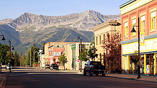
Fernie is a city in the Elk Valley area of the East Kootenay region of southeastern British Columbia, Canada, located on BC Highway 3 on the western approaches to the Crowsnest Pass through the Rocky Mountains. Founded in 1898 and incorporated as the City of Fernie in July 1904, the municipality has a population of over 5,000 with an additional 2,000 outside city limits in communities under the jurisdiction of the Regional District of East Kootenay. A substantial seasonal population swells the city during the winter months.

Grande Prairie is a city in northwestern Alberta, Canada, within the southern portion of an area known as Peace River Country. It is located at the intersection of Highway 43 and Highway 40, approximately 456 km (283 mi) northwest of Edmonton. The city is surrounded by the County of Grande Prairie No. 1.

East Williamsburg is a name for the area in the northwestern portion of Brooklyn, New York City, United States. East Williamsburg consists roughly of what was the 3rd District of the Village of Williamsburgh and what is now called the East Williamsburg In-Place Industrial Park (EWIPIP), bounded by the neighborhoods of Northside and Southside Williamsburg to the west, Greenpoint to the north, Bushwick to the south and southeast, and both Maspeth and Ridgewood in Queens to the east. Much of this area is still referred to as either Bushwick, Williamsburg, or Greenpoint with the term East Williamsburg falling out of use since the 1990s.

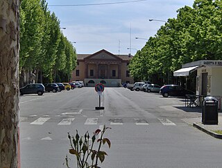
Reggio nell'Emilia, usually referred to as Reggio Emilia, or simply Reggio by its inhabitants, and known until 1861 as Reggio di Lombardia, is a city in northern Italy, in the Emilia-Romagna region. It has about 171,944 inhabitants and is the main comune (municipality) of the province of Reggio Emilia.

The Panaro is an Italian river and the final right-hand tributary to the Po, discounting the Cavo Napoleonico canal. It runs right across Emilia-Romagna in a north-easterly direction: from its source close to the Apennine watershed, where Emilia-Romagna meets Tuscany, to its outlet where the Po marks the region's boundary with Veneto. Its Latin name was Scultenna.

Verbania is the most populous comune (municipality) and the capital city of the province of Verbano-Cusio-Ossola in the Piedmont region of northwest Italy. It is situated on the shore of Lake Maggiore, about 91 km (57 mi) north-west of Milan and about 40 km (25 mi) from Locarno in Switzerland. It had a population of 30,827 on 1 January 2017.

Salvadore Cammarano was an Italian librettist and playwright perhaps best known for writing the text of Lucia di Lammermoor (1835) for Gaetano Donizetti.

The Christian Quarter is one of the four quarters of the walled Old City of Jerusalem, the other three being the Jewish Quarter, the Muslim Quarter and the Armenian Quarter. The Christian Quarter is situated in the northwestern corner of the Old City, extending from the New Gate in the north, along the western wall of the Old City as far as the Jaffa Gate, along the Jaffa Gate - Western Wall route in the south, bordering on the Jewish and Armenian Quarters, as far as the Damascus Gate in the east, where it borders on the Muslim Quarter.
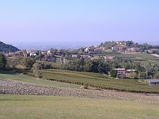
Pozzol Groppo is a comune (municipality) in the Province of Alessandria in the Italian region Piedmont, located about 110 kilometres (68 mi) east of Turin and about 35 kilometres (22 mi) east of Alessandria.
Lambrugo is a comune (municipality) in the Province of Como in the Italian region Lombardy, located about 30 kilometres (19 mi) north of Milan and about 14 kilometres (9 mi) southeast of Como. As of 30 November 2019, it had a population of 2,510 and an area of 1.9 km2. The municipality of Lambrugo contains the frazioni Momberto, Galletto, Cascina Giulia, and Resegone. Lambrugo borders the following municipalities: Costa Masnaga, Inverigo, Lurago d'Erba, Merone, Nibionno.

Nembro is a comune (municipality) in the Province of Bergamo in the Italian region of Lombardy, located about 60 kilometres (37 mi) northeast of Milan and about 10 kilometres (6 mi) northeast of Bergamo, on the right bank of the Serio River.

Gattatico is a comune (municipality) in the Province of Reggio Emilia in the Italian region Emilia-Romagna.
Rio Saliceto is a comune (municipality) in the Province of Reggio Emilia in the Italian region Emilia-Romagna, located about 60 kilometres (37 mi) northwest of Bologna and about 20 kilometres (12 mi) northeast of Reggio Emilia.

Fiumalbo is a comune (municipality) in the Province of Modena in the Italian region Emilia-Romagna, located about 70 kilometres (43 mi) southwest of Bologna and about 60 kilometres (37 mi) southwest of Modena.

Pievepelago is a comune (municipality) in the Province of Modena in the Italian region of Emilia-Romagna in the heart of the northern Apennine Mountains. Situated on the Scoltenna River, in a mountain valley, it is a tourist resort crossed by the Via Vandelli.
Riolunato is a comune (municipality) in the Province of Modena in the Italian region Emilia-Romagna, located about 60 kilometres (37 mi) southwest of Bologna and about 50 kilometres (31 mi) southwest of Modena. It is overlooked from the south by the Monte Cimone. Its fraction Le Polle, about 1,300 metres (4,300 ft) high, is one of the most important stations in the Monte Cimone Ski resort.

Sestola is a comune (municipality) in the province of Modena, in the Italian region of Emilia-Romagna, located about 60 kilometres (37 mi) southwest of Bologna and about 50 kilometres (31 mi) southwest of Modena. It is located near the Monte Cimone and other mountains of the northern Apennines separating Emilia and Tuscany.

Fosciandora is a comune (municipality) of 554 inhabitants in the Province of Lucca in the Italian region Tuscany, located about 70 kilometres (43 mi) northwest of Florence and about 30 kilometres (19 mi) north of Lucca.
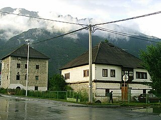
Gusinje Municipality is a municipality in northern Montenegro. It is located in the upper Lim valley at an elevation of about 1,000 m (3,000 ft). It was created in 2014, when it split from Plav Municipality. Its center is the small town of Gusinje, and its biggest village in terms of territory is Vusanje. Two of Montenegro's highest mountains overlook Gusinje: Zla Kolata and Visitor. Many of Gusinje's settlements are historically linked with the Albanian Kelmendi tribe (fis). The village of Gusinje developed into a town the 17th century around a fortress built by the Ottomans to contain the Kelmendi. In the 19th century, Gusinje was a developing regional market center. It was engulfed in 1879–1880 in a struggle between the Principality of Montenegro that wanted to annex it and the League of Prizren that opposed it. After the Balkan Wars, Gusinje became part of Montenegro and in 1919 part of Yugoslavia. Today, it is part of Montenegro since its declaration of independence in 2006.

