
Unterwalden, translated from the Latin inter silvas(between the forests), is the old name of a forest-canton of the Old Swiss Confederacy in central Switzerland, south of Lake Lucerne, consisting of two valleys or Talschaften, now two separate Swiss cantons, Obwalden and Nidwalden.

Obwalden, also Obwald, is one of the 26 cantons forming the Swiss Confederation. It is composed of seven municipalities and the seat of the government and parliament is in Sarnen. It is traditionally considered a "half-canton", the other half being Nidwalden.
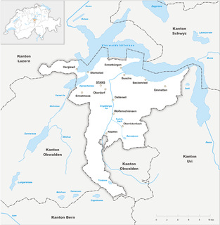
Nidwalden, also Nidwald is one of the 26 cantons forming the Swiss Confederation. It is composed of eleven municipalities and the seat of the government and parliament is in Stans. It is traditionally considered a "half-canton", the other half being Obwalden.
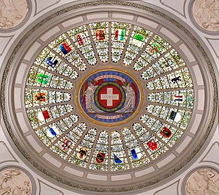
Each of the 26 modern cantons of Switzerland has an official flag and a coat of arms. The history of development of these designs spans the 13th to the 20th centuries.
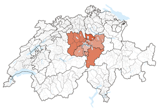
Central Switzerland is the region of the Alpine foothills geographically the heart and historically the origin of Switzerland, with the cantons of Uri, Schwyz, Obwalden, Nidwalden, Lucerne and Zug.

Waldstätten was a canton of the Helvetic Republic from 1798 to 1803, combining the territories of the founding cantons of the Old Swiss Confederacy, Uri, Schwyz and both cantons of Unterwalden, which were collectively known as Waldstätten since the 14th century, along with Zug, the Republic of Gersau, and Engelberg Abbey.

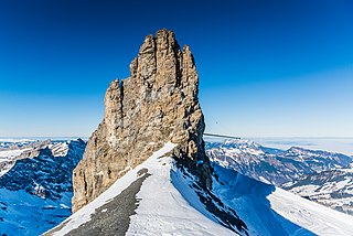
Titlis is a mountain of the Uri Alps, located on the border between the cantons of Obwalden and Bern. At 3,238 metres (10,623 ft) above sea level, it is the highest summit of the range north of the Susten Pass, between the Bernese Oberland and Central Switzerland. It is mainly accessed from Engelberg (OW) on the north side and is famous as the site of the world's first rotating cable car. The cable car system connects Engelberg to the summit of Klein Titlis through the three stages of Gerschnialp, Trübsee and Stand.

Ächerli Pass is a high mountain pass between the cantons of Obwalden and Nidwalden.

The Uri Alps are a mountain range in Central Switzerland and part of the Western Alps. They extend into the cantons of Obwalden, Valais, Bern, Uri and Nidwalden and are bordered by the Bernese Alps and the Emmental Alps to the west, the Schwyzer Alps to the north, the Lepontine Alps to the south and the Glarus Alps to the east (Reuss).
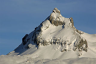
The Rotstöckli is a peak of the Urner Alps below the Titlis, on the border between the Swiss cantons of Obwalden and Nidwalden. It is Nidwalden's highest point. The summit is split between the municipalities of Engelberg (Obwalden) and Wolfenschiessen (Nidwalden).

The Rigidalstock is a mountain of the Urner Alps, located on the border between the cantons of Nidwalden and Obwalden in Central Switzerland. It lies south of the Gross Walenstock.

The Huetstock is a mountain of the Urner Alps, located on the border between Nidwalden and Obwalden in Central Switzerland. It is located between the valleys of Melchtal and Engelberg, just north of the Rotsandnollen.
The Graustock is a mountain of the Urner Alps, located south of Engelberg in Central Switzerland. The summit is one of the two tripoints between the cantons of Berne, Nidwalden and Obwalden.
The Jochstock is a summit of the Urner Alps, located near Engelberg in Central Switzerland. The summit is one of the two tripoints between the cantons of Berne, Nidwalden and Obwalden.

The Widderfeld is a mountain in the Emmental Alps, located west of the Pilatus in Central Switzerland. The summit lies on the border between the cantons of Obwalden and Lucerne. The tripoint between the cantons of Lucerne, Obwalden and Nidwalden lies 300 m north of the summit.

The Rotsandnollen is a mountain of the Urner Alps, located between Melchsee-Frutt and Engelberg in Central Switzerland. The summit is located on the border between the cantons of Nidwalden and Obwalden.

The Gross Sättelistock is a mountain of the Urner Alps, located on the border between the cantons of Nidwalden and Obwalden in Central Switzerland. It lies north of Engelberg.
The Schluchberg is a mountain of the Uri Alps, located on the border between the Swiss cantons of Obwalden and Nidwalden. It is the highest summit of the chain north of the Storegg pass.

The Widderfeld Stock is a mountain of the Urner Alps, located on the border between the Swiss cantons of Nidwalden and Obwalden. It is located between the valleys of Melchtal and Engelberg.
The Nünalphorn is a mountain of the Urner Alps, located on the border between the Swiss cantons of Nidwalden and Obwalden. It is located between the valleys of Melchtal and Engelberg.

