Grouse Creek block

Last updated
Fig. 1. Location of the Grouse Creek block and relevant adjacent geologic and geographic landmarks. Grouse Creek block location1.jpg
Fig. 1. Location of the Grouse Creek block and relevant adjacent geologic and geographic landmarks.

The Grouse Creek block is a Precambrian basement province of 2.45 to 2.70 billion year old orthogneisses. [2] [3] The Grouse Creek block is one of several Proterozoic and Archean accreted terranes that lie to the north and west of the Wyoming craton, including the Farmington Canyon Complex (<2.5 Ga), the Selway terrane (2.4-1.6 Ga), the Medicine Hat block (2.6-3.3 Ga) and the Priest River complex (>2.6-1.5 Ga). [1] Together, these terranes comprise part of the basement rock of the North American continent [1] and have been critical to studies of crustal accretion in the Precambrian. Ongoing study of the Grouse Creek block will contribute to understanding the paleogeography of the Wyoming craton prior to its incorporation into the supercontinent Laurentia approximately 1.86 billion years ago. The name was proposed by David Foster and others. [1]

Contents

Geographic and geologic boundaries

The location of the Grouse Creek block has been determined at some points by determining the age when minerals were metamorphosed through isotopic analysis of uranium, strontium, neodymium and lead. [4] The ages matched characteristic outcropping Archean orthogneisses. [5] Outcrops have been sampled in the Pioneer Mountains, [5] [6] the Albion Range, [7] the East Humboldt Range, [8] [9] and the Grouse Creek Range. [10] Results indicate that while surface exposures of the Grouse Creek block are rare, the extent of the block is large, reaching from southern Idaho to northeastern Nevada and northwestern Utah (Fig. 1). [11] [12] The boundaries of the block remain a topic of significant study.

North Boundary: North of the Snake River Plain to at least the Pioneer Core Complex. [1] [5] [6] [13]
East Boundary: It is generally accepted that the eastern edge is separated from the Wyoming craton by Paleoproterozoic rocks of the Farmington Canyon Complex [14] in the Wasatch Range of Utah. [15] [16]
South Boundary: May occur between the East Humboldt Range and Ruby Mountains in Nevada where U-Pb geochronology and Sr, Nd and Pb isotope analysis of intrusive rocks indicate Archean basement is truncated by Proterozoic basement of the Cheyenne Belt. [8] [9]
West Boundary: Not well defined largely due to a lack of outcropping rock, though it has been hypothesized that the block could extend to the Neoproterozoic Cordilleran rift margin. [1]

History of study

Initial geochronology of the Grouse Creek block in 1967 provided age dates identical to those of the Wyoming craton, causing the margin between the two to be blurred. [11] [16] The Grouse Creek block was later proposed as a separate terrane following the discovery of outcropping 2.45 to 1.6 billion year old Paleoproterozoic metasedimentary rocks [17] of the Farmington Canyon Complex in the Wasatch Range of Utah separating the block from the Wyoming craton. [15] [16] There is still debate as to whether the Grouse Creek block is distinct from the Wyoming Craton at depth. [14] [18] Geologists proposed three hypotheses for the provenance of the Grouse Creek block: [1] [14]

  1. The Grouse Creek block could be an accreted Archean block.
  2. It may be a re-accreted rifted fragment of the Wyoming craton.
  3. Or the block could be a part of the Wyoming craton separated by a younger intracratonic rift.

Geo- and thermochronologic data indicates mountain building and magmatism in the Farmington Canyon Complex at 2.45 and 1.8 billion years ago [1] [15] can be attributed to accretion of the Grouse Creek block to the Wyoming craton in the Paleoproterozoic. [17] [18] The Wyoming craton can be differentiated from other Archean terranes by an enriched 207Pb/204Pb ratio that is hypothesized to represent early crustal extraction, as well as samarium and neodymium ratios providing rock ages of up to 4.0 Ga. [14] Investigation of lead and neodymium isotope ratios in the Grouse Creek block provide evidence that it is chemically unique with respect to the Wyoming craton, corroborating past studies indicating the accretion of the terrane to the western margin of the Wyoming craton in the Paleoproterozoic (Fig. 2). [14]

Fig. 2. Possible sequence of an accretionary event involving an exotic terrane and a continental landmass. Accretion of the Grouse Creek block onto the Wyoming craton is proposed to occur through this process. AccreWedge.jpg
Fig. 2. Possible sequence of an accretionary event involving an exotic terrane and a continental landmass. Accretion of the Grouse Creek block onto the Wyoming craton is proposed to occur through this process.

Related Research Articles

<span class="mw-page-title-main">Slave Craton</span> Archaean craton in the north-western Canadian Shield, in Northwest Territories and Nunavut

The Slave Craton is an Archaean craton in the north-western Canadian Shield, in Northwest Territories and Nunavut. The Slave Craton includes the 4.03 Ga-old Acasta Gneiss which is one of the oldest dated rocks on Earth. Covering about 300,000 km2 (120,000 sq mi), it is a relatively small but well-exposed craton dominated by ~2.73–2.63 Ga greenstones and turbidite sequences and ~2.72–2.58 Ga plutonic rocks, with large parts of the craton underlain by older gneiss and granitoid units. The Slave Craton is one of the blocks that compose the Precambrian core of North America, also known as the palaeocontinent Laurentia.

<span class="mw-page-title-main">Kaapvaal Craton</span> Archaean craton, possibly part of the Vaalbara supercontinent

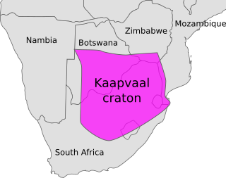
The Kaapvaal Craton, along with the Pilbara Craton of Western Australia, are the only remaining areas of pristine 3.6–2.5 Ga crust on Earth. Similarities of rock records from both these cratons, especially of the overlying late Archean sequences, suggest that they were once part of the Vaalbara supercontinent.

<span class="mw-page-title-main">Geology of the Rocky Mountains</span> Discontinuous series of North American mountain ranges with distinct geological origin

The geology of the Rocky Mountains is that of a discontinuous series of mountain ranges with distinct geological origins. Collectively these make up the Rocky Mountains, a mountain system that stretches from Northern British Columbia through central New Mexico and which is part of the great mountain system known as the North American Cordillera.

<span class="mw-page-title-main">Río de la Plata Craton</span> Medium-sized continental block in Uruguay, eastern Argentina and southern Brazil

The Rio de la Plata Craton (RPC) is a medium-sized continental block found in Uruguay, eastern Argentina and southern Brazil. During its complex and protracted history it interacted with a series other blocks and is therefore considered important for the understanding of the amalgamation of West Gondwana. Two orogenic cycles have been identified in the RPC: a 2000 Ma-old western domain representing the old craton and a 700–500 Ma-old eastern domain assigned to the Brasiliano Cycle. It is one of the five cratons of the South American continent. The other four cratons are: Amazonia, São Francisco, Río Apa and Arequipa–Antofalla.

<span class="mw-page-title-main">Trans-Hudson orogeny</span> Mountain-building event in North America

The Trans-Hudson orogeny or Trans-Hudsonian orogeny was the major mountain building event (orogeny) that formed the Precambrian Canadian Shield and the North American Craton, forging the initial North American continent. It gave rise to the Trans-Hudson orogen (THO), or Trans-Hudson Orogen Transect (THOT), which is the largest Paleoproterozoic orogenic belt in the world. It consists of a network of belts that were formed by Proterozoic crustal accretion and the collision of pre-existing Archean continents. The event occurred 2.0–1.8 billion years ago.

<span class="mw-page-title-main">Wyoming Craton</span> Craton in the west-central United States and western Canada

The Wyoming Craton is a craton in the west-central United States and western Canada – more specifically, in Montana, Wyoming, southern Alberta, southern Saskatchewan, and parts of northern Utah. Also called the Wyoming Province, it is the initial core of the continental crust of North America.

<span class="mw-page-title-main">Taltson Magmatic Zone</span> Belt of Archean to Paleoproterozoic rock in the Canadian Shield

The Taltson Magmatic Zone (TMZ) is a north-trending belt of Archean to Paleoproterozoic granitic basement gneiss, amphibolite supracrustal gneissic rock and Paleoproterozoic magmatic rocks in the Canadian Shield, extending from Northern Alberta to the southwestern Northwest Territories. The TMZ basement is 3.2–3.0 Ga and the Rutledge River supracrustal gneisses 2.13–2.09 Ga years old and were intruded by magmatic rocks around 1.99–1.92 Ga.

The Great Lakes tectonic zone (GLTZ) is bounded by South Dakota at its tip and heads northeast to south of Duluth, Minnesota, then heads east through northern Wisconsin, Marquette, Michigan, and then trends more northeasterly to skim the northernmost shores of lakes.

The Cheyenne Belt is the tectonic suture zone between the Archean-age Wyoming craton to the north and the Paleoproterozoic-age Yavapai province to the south. It runs through the southeastern quadrant of the state of Wyoming, United States. It was formed during the Paleoproterozoic Medicine Bow orogeny between 1.78 and 1.74 billion years ago when island arcs collided with the Wyoming craton. This is an example of a convergent boundary in tectonics.

The Hottah terrane is a Paleoproterozoic terrane in the northwestern end of the Canadian Shield which is exposed near Hottah Lake, Northwest Territories. It is a belt of multi-deformed metasedimentary and metavolcanic rocks intruded by a series of diorite to granite plutons. Forming the western part of the Wopmay orogenic system, the 1.9 Ga Hottah terrane is separated from the Archean rocks of the orogen by the north-trending Wopmay fault zone and overprinted by the 1.875-1.85 Ga Great Bear magmatism.

<span class="mw-page-title-main">Tectonic evolution of the Aravalli Mountains</span> Overview article

The Aravalli Mountain Range is a northeast-southwest trending orogenic belt in the northwest part of India and is part of the Indian Shield that was formed from a series of cratonic collisions. The Aravalli Mountains consist of the Aravalli and Delhi fold belts, and are collectively known as the Aravalli-Delhi orogenic belt. The whole mountain range is about 700 km long. Unlike the much younger Himalayan section nearby, the Aravalli Mountains are believed much older and can be traced back to the Proterozoic Eon. They are arguably the oldest geological feature on Earth. The collision between the Bundelkhand craton and the Marwar craton is believed to be the primary mechanism for the development of the mountain range.

<span class="mw-page-title-main">Eastern Block of the North China Craton</span>

The Eastern Block of the North China Craton is one of the Earth's oldest pieces of continent. It is separated from the Western Block by the Trans-North China Orogen. It is situated in northeastern China and North Korea. The Block contains rock exposures older than 2.5 billion years. It serves as an ideal place to study how the crust was formed in the past and the related tectonic settings.

<span class="mw-page-title-main">South China Craton</span> Precambrian continental block located in China

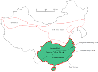
The South China Craton or South China Block is one of the Precambrian continental blocks in China. It is traditionally divided into the Yangtze Block in the NW and the Cathaysia Block in the SE. The Jiangshan–Shaoxing Fault represents the suture boundary between the two sub-blocks. Recent study suggests that the South China Block possibly has one more sub-block which is named the Tolo Terrane. The oldest rocks in the South China Block occur within the Kongling Complex, which yields zircon U–Pb ages of 3.3–2.9 Ga.

<span class="mw-page-title-main">Western Block of the North China Craton</span>

The Western Block of the North China Craton is an ancient micro-continental block mainly composed of Neoarchean and Paleoproterozoic rock basement, with some parts overlain by Cambrian to Cenozoic volcanic and sedimentary rocks. It is one of two sub-blocks within the North China Craton, located in east-central China. The boundaries of the Western Block are slightly different among distinct models, but the shapes and areas are similar. There is a broad consensus that the Western Block covers a large part of the east-central China.

The Superior Craton is a stable crustal block covering Quebec, Ontario, and southeast Manitoba in Canada, and northern Minnesota in the United States. It is the biggest craton among those formed during the Archean period. A craton is a large part of the Earth's crust that has been stable and subjected to very little geological changes over a long time. The size of Superior Craton is about 1,572,000 km2. The craton underwent a series of events from 4.3 to 2.57 Ga. These events included the growth, drifting and deformation of both oceanic and continental crusts.

<span class="mw-page-title-main">Aldan Shield</span>

Aldan Shield is a shield in Siberia. It is an exposed basement of the Siberian Craton. Together with the Anabar Shield further to the northwest, the Aldan Shield is one of the main features of the craton.

<span class="mw-page-title-main">Mazatzal orogeny</span> Mountain-building event in North America

The Mazatzal orogeny was an orogenic event in what is now the Southwestern United States from 1650 to 1600 Mya in the Statherian Period of the Paleoproterozoic. Preserved in the rocks of New Mexico and Arizona, it is interpreted as the collision of the 1700-1600 Mya age Mazatzal island arc terrane with the proto-North American continent. This was the second in a series of orogenies within a long-lived convergent boundary along southern Laurentia that ended with the ca. 1200–1000 Mya Grenville orogeny during the final assembly of the supercontinent Rodinia, which ended an 800-million-year episode of convergent boundary tectonism.

<span class="mw-page-title-main">Picuris orogeny</span> Mountain-building event in what is now the Southwestern US

The Picuris orogeny was an orogenic event in what is now the Southwestern United States from 1.43 to 1.3 billion years ago in the Calymmian Period of the Mesoproterozoic. The event is named for the Picuris Mountains in northern New Mexico and interpreted either as the suturing of the Granite-Rhyolite crustal province to the southern margin of the proto-North American continent Laurentia or as the final suturing of the Mazatzal crustal province onto Laurentia. According to the former hypothesis, this was the second in a series of orogenies within a long-lived convergent boundary along southern Laurentia that ended with the ca. 1200–1000 Mya Grenville orogeny during the final assembly of the supercontinent Rodinia, which ended an 800-million-year episode of convergent boundary tectonism.

<span class="mw-page-title-main">Dharwar Craton</span> Part of the Indian Shield in south India

The Dharwar Craton is an Archean continental crust craton formed between 3.6-2.5 billion years ago (Ga), which is located in southern India and considered as the oldest part of the Indian peninsula.

<span class="mw-page-title-main">Geology of the Kimberley (Western Australia)</span> Overview of geology of the Kimberley

The geology of the Kimberley, a region of Western Australia, is a rock record of the early Proterozoic eon that includes tectonic plate collision, mountain-building (orogeny) and the joining (suturing) of the Kimberley and Northern Australia cratons, followed by sedimentary basin formation.

References

  1. 1 2 3 4 5 6 7 8 Foster, David A; Paul A Mueller; David W Mogk; Joseph L Wooden; James J Vogl (2006). "Proterozoic evolution of the western margin of the Wyoming craton: implications for the tectonic and magmatic evolution of the northern Rocky Mountains" (PDF). Canadian Journal of Earth Sciences. 43 (10): 1601–1619. Bibcode:2006CaJES..43.1601F. doi:10.1139/E06-052. ISSN   0008-4077 . Retrieved 29 December 2012.
  2. Wilhelmi, Ryan M. (2019-09-22). "GROUSE CREEK BLOCK: RIFTED FRAGMENT OF THE WYOMING CRATON? EXTENSION OF MOJAVE?". GSA.{{cite journal}}: Cite journal requires |journal= (help)
  3. Link, Paul K.; Vogl, James J.; Fanning, C. Mark; Cameron, Angie; Autenrieth-Durk, Kathleen M.; Foster, David A. (2017-06-01). "U-Pb zircon ages of the Wildhorse gneiss, Pioneer Mountains, south-central Idaho, and tectonic implications". Geosphere. 13 (3): 681–698. Bibcode:2017Geosp..13..681L. doi: 10.1130/GES01418.1 . hdl: 1885/202756 .
  4. Leeman, William P.; Martin A. Menzies; David J. Matty; Glen F. Embree (1985). "Strontium, neodymium and lead isotopic compositions of deep crustal xenoliths from the Snake River Plain: evidence for Archean basement". Earth and Planetary Science Letters. 75 (4): 354–368. Bibcode:1985E&PSL..75..354L. doi:10.1016/0012-821X(85)90179-7. ISSN   0012-821X.
  5. Armstrong, R.L.; and Hills, F.A. "Rb–Sr and K–Ar geochrono- logic studies of mantled gneiss domes, Albion Range, southern Idaho, USA." Earth and Planetary Science Letters, 3: 114–124 (1967).
  6. 1 2 Wright, J.E.; and Snoke, A.W. "Tertiary magmatism and mylonitization in the Ruby – East Humboldt metamorphic core complex, northeastern Nevada; U–Pb geochronology and Sr, Nd, and Pb isotope geochemistry." Geological Society of America Bulletin, 105: 935–952 (1993).
  7. 1 2 Premo, W.R.; Howard, K.A.; and Castineiras, P. "New SHRIMP U–Pb zircon ages and Nd isotopic signatures for plutonism in the northern Ruby – East Humboldt Ranges of NE Nevada: implications for the timing of Tertiary core complex formation." Geological Society of America, Abstracts with Programs, 37: 359 (2005).
  8. Hoisch, Thomas D.; Michael L. Wells; Marty Grove (2008). "Age trends in garnet-hosted monazite inclusions from upper amphibolite facies schist in the northern Grouse Creek Mountains, Utah". Geochimica et Cosmochimica Acta. 72 (22): 5505–5520. Bibcode:2008GeCoA..72.5505H. doi:10.1016/j.gca.2008.08.012. ISSN   0016-7037.
  9. 1 2 Fleck, R.J.; and Wooden, J.L. "Isotopic identification of the Archean/Proterozoic lithosphere." Geological Society of America, Abstracts with Programs, 29:70-71 (1997).
  10. Wolf, D.E.; Leeman, W.P.; and Vervoort, J.D. "U–Pb zircon geochronology of crustal xenoliths confirms presence of Archean basement beneath the central and eastern Snake River Plain." Geological Society of America, Abstracts with Programs, 37: 60 (2005).
  11. Gaschnig, R. M.; Vervoort, J. D.; Lewis, R. S.; Tikoff, B. (2013-01-01). "Probing for Proterozoic and Archean crust in the northern U.S. Cordillera with inherited zircon from the Idaho batholith". Geological Society of America Bulletin. 125 (1–2): 73–88. Bibcode:2013GSAB..125...73G. doi:10.1130/B30583.1.
  12. 1 2 3 4 5 Foster, D.A.; Mueller, P.A.; Kamenov, G.D.; and Stroud, M. "Isotopic analyses of the Grouse Creek Block; A link to the Wyoming Craton?" Geological Society of America, Abstracts with Programs, 41: 270 (2009).
  13. 1 2 3 Nelson, S.; Harris, R.; Dorais, M.; Heizler, M.; Constenius, K.; and Barnett, D. "Basement complexes in the Wasatch fault, Utah, provide new limits on crustal accretion." Geology. 30:831–834 (2002).
  14. 1 2 3 Bryant, B. 1988. "Geology of the Farmington Canyon complex, Wasatch Mountains, Utah." US. Geological Survey Professional Paper 1476.
  15. 1 2 Barnett, D.; Bowman, J.; and Smith, H. "Petrologic and geo- chronologic studies in the Farmington Canyon complex, Wasatch Mountains, Utah." Utah Geological Survey Contract Report 93-5 (1993).
  16. 1 2 Mueller, P.; Foster, D.; Mogk, D.; and Wooden, J. "New insights into the Proterozoic evolution of the western margin of Laurentia and their tectonic implications." Geological Society of America, Abstracts with Programs, 36: 404 (2004).
  17. 2006. Pearson Prentice Hall, Inc.

Gaschnig, R. M.; Vervoort, J. D.; Lewis, R. S.; Tikoff, B. (2013-01-01). "Probing for Proterozoic and Archean crust in the northern U.S. Cordillera with inherited zircon from the Idaho batholith". Geological Society of America Bulletin. 125 (1–2): 73–88. Bibcode:2013GSAB..125...73G. doi:10.1130/B30583.1.

41°N115°W / 41°N 115°W / 41; -115