Grovely Wood

Last updated

Beech trees lining a road through Grovely GrovelyWoods1.JPG
Beech trees lining a road through Grovely

Grovely Wood is one of the largest woodlands in southern Wiltshire, England. It stands on a chalk ridge above the River Wylye in Barford St Martin parish, to the southwest of the village of Great Wishford, within the Cranborne Chase and West Wiltshire Downs Area of Outstanding Natural Beauty. The Sarum Way enters the wood.

Contents

It is recognised for its nature conservation importance through designation as a County Wildlife Site. Among the species found here is the Purple Emperor butterfly. [1]

To the west of Grovely, on the same ridge, lies another large block of woodland, Great Ridge Wood. Adjacent to Grovely, to the north, lies the grassland Site of Special Scientific Interest Ebsbury Down. Another SSSI, Baverstock Juniper Bank, is also nearby.

There is much Iron Age and Roman archaeology in the vicinity of the woods. A Roman road runs east to west through the centre of the wood, and at the western end are the Iron Age/Romano-British settlements of Hanging Langford Camp and Church End Ring. Just to the north of the woods lie the sites of two Iron Age hillforts, Ebsbury, and Grovely castle; as well as an Iron Age farm enclosure, known as East Castle.

Boundaries

In the 13th century, Grovely Forest extended north and east to the River Wylye, and south to the Nadder; on its western boundary were the villages of Wylye and Teffont Evias. [2]

At a Grovely swainmote held in March 1603, a jury drawn from Great Wishford and Barford St. Martin declared that the forest then consisted of fourteen coppices. Seven lay north of 'Grim's Dyke' in Great Wishford, while the others lay south of the dyke in Barford St. Martin. The combined areas of these fourteen coppices correspond to what was formerly the extra-parochial area of Grovely Wood. [2] By 1839, the boundary of Barford parish had moved north to include almost all of the woodland. [3]

Ancient custom

According to a mediaeval custom, villagers of Great Wishford have a right to gather firewood in Grovely Wood on Oak Apple Day, May 29. On this day, villagers claim their ancient rights to collect wood from Grovely, said to date back to the Middle Ages and to have been confirmed by the Forest Court in 1603, thanks to a charter for the collection of wood in the Royal Forest of Groveley. [4]

Folklore

Grovely Wood has two stories associated with it.

The Handsel sisters

The four Handsel sisters were of Danish origin but they had moved to the Wilton area. Coincidentally, an outbreak of smallpox in 1737 killed 132 people. [5] The local people became convinced that the sisters were responsible for the deaths and accused them of witchcraft and an alliance with the devil. Without an official hearing the sisters were taken to Grovely Wood, murdered by being bludgeoned over the head, and buried a little way apart from each other so that they could not conspire against their murderers. There are four gnarled beech trees associated with the sisters; because either the trees were planted to mark their graves or they mysteriously grew on top of the unmarked graves to remind the locals of their dreadful deed. Sightings of the sisters have been reported over the years. There is a hollow at the back of the largest tree where people leave offerings. The trees are located approximately 50 meters away from the Roman road some ten minutes walk from the Wilton end of the wood. [6]

The Burcombe Woodsman

The Burcombe Woodsman is thought to be a poacher who was hanged from a tree for his 'crimes', or possibly an artist who painted in watercolour and was accidentally shot in the woods during a deer cull. It is said that he lodged in Burcombe thus earning him the title of the Burcombe Woodsman. Sightings of him have been reported, usually after hearing the cracking of a twig.[ citation needed ]

An image on Purbeck marble found at Steeple Langford in 1857, a portrait of a man wearing a long robe, with a horn hanging from his left shoulder, may be of Alan de Langford, Verderer of Grovely Wood at the end of the 13th century. [7] [8]

The Beauties of England and Wales (1814)

The antiquary John Britton reports in a volume of his The Beauties of England and Wales (1814) that

...the Great Ridge Wood... was anciently conjoined with Grovely-Wood, but is now separated from it by an extent of nearly four miles of open down. The whole was then designated by the appellation of Grovely-Forest, and such it appears to have been so late as the thirty-third year of Queen Elizabeth, when a law-suit occurred between Edward, Earl of Hertford, and the Queen's Majesty, in behalf of Henry, Earl of Pembroke, concerning the bounds of the forest of Grovely in the county of Wilts, in which it was decided that the last perambulation of 28 Edward I, and no other, stood good in law. In the middle of this wood is a house still retaining the appellation of Grovely-Lodge. In traversing the boundaries of Grovely-Wood, the antiquary perceives several ancient works to arrest his attention, besides the entrenchments above noticed. These are denominated East-Castle, Grovely-Castle, Grovely-Works, and Hamshill ditches, of which the first three are situated on the southern side of the wood, and the last on its northern side opposite the village of Barford." [9]

Second World War

The Royal Air Force had an ordnance depot at Chilmark, west of the wood, during and after the Second World War, and parts of the wood provided cover for munitions storage. Until c.1951, use was made of sidings at the nearest station, Wylye; [10] the area was also used for the same purpose by the United States Air Force, via Wishford station. [11]

Related Research Articles

<span class="mw-page-title-main">Coppicing</span> Method of tree management

Coppicing is a traditional method of woodland management which exploits the capacity of many species of trees to put out new shoots from their stump or roots if cut down. In a coppiced wood, which is called a copse, young tree stems are repeatedly cut down to near ground level, resulting in a stool. New growth emerges, and after a number of years, the coppiced tree is harvested, and the cycle begins anew. Pollarding is a similar process carried out at a higher level on the tree in order to prevent grazing animals from eating new shoots. Daisugi, is a similar Japanese technique.

<span class="mw-page-title-main">Ancient woodland</span> Type of woodland in the United Kingdom

In the United Kingdom, an ancient woodland is a woodland that has existed continuously since 1600 or before in England, Wales and Northern Ireland. Planting of woodland was uncommon before those dates, so a wood present in 1600 is likely to have developed naturally.

<span class="mw-page-title-main">History of Wiltshire</span>

Wiltshire is a historic county located in the South West England region. Wiltshire is landlocked and is in the east of the region.

<span class="mw-page-title-main">Barford St Martin</span> Village in Wiltshire, England

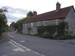
Barford St Martin is a village and civil parish in Wiltshire, England, about 2.5 miles (4 km) west of Wilton, around the junction of the A30 and the B3089. Barford is known as one of the Nadder Valley villages, named for the River Nadder which flows through the parish.

<span class="mw-page-title-main">Savernake Forest</span> 4500 acre forest in Wiltshire, England

Savernake Forest stands on a Cretaceous chalk plateau between Marlborough and Great Bedwyn in Wiltshire, England. Its area is approximately 4,500 acres.

<span class="mw-page-title-main">Wylye</span> Human settlement in England

Wylye is a village and civil parish on the River Wylye in Wiltshire, England. The village is about 9+12 miles (15 km) northwest of Salisbury and a similar distance southeast of Warminster.

<span class="mw-page-title-main">Hatfield Forest</span> Nature reserve in England

Hatfield Forest is a 403.2-hectare (996-acre) biological Site of Special Scientific Interest in Essex, three miles east of Bishop's Stortford. It is also a National Nature Reserve and a Nature Conservation Review site. It is owned and managed by the National Trust. A medieval warren in the forest is a Scheduled Monument.

The River Nadder is a tributary of the River Avon, flowing in south Wiltshire, England.

<span class="mw-page-title-main">Bedford Purlieus National Nature Reserve</span> Ancient woodland in Cambridgeshire, England

Bedford Purlieus is a 211-hectare (520-acre) ancient woodland in Cambridgeshire, in the United Kingdom. It is a national nature reserve and Site of Special Scientific Interest owned and managed by the Forestry Commission. In Thornhaugh civil parish, 10 km (6.2 mi) south of Stamford and 14 km (8.7 mi) west of Peterborough, the wood is within the Peterborough unitary authority area of Cambridgeshire, and borders Northamptonshire. In Roman times it was an iron smelting centre, during the medieval period it was in the Royal Forest of Rockingham, and later it became part of the estates of the Duke of Bedford. Bedford Purlieus appears to have been continuously wooded at least from Roman times, and probably since the ice receded. The woodland may have the richest range of vascular plants of any English lowland wood. It acquired particular significance in the 1970s as an early subject for the historical approach to ecology and woodland management.

The Salisbury branch line of the Great Western Railway from Westbury to Salisbury in Wiltshire, England, was completed in 1856. Most of the smaller stations were closed in 1955 but the line remains in use as part of the Wessex Main Line.

<span class="mw-page-title-main">Great Wishford</span> Human settlement in England

Great Wishford is a village and civil parish in the Wylye Valley in Wiltshire, England, about three miles (5 km) north of Wilton and five miles (8 km) northwest of Salisbury. The village lies west of a bend in the River Wylye and has a triangular street layout comprising South Street, West Street and Station Road.

<span class="mw-page-title-main">Steeple Langford</span> Human settlement in England

Steeple Langford is a village and civil parish in the English county of Wiltshire, 6 miles (10 km) northwest of Wilton. It has also been called Great Langford or Langford Magna. The village lies on the north bank of the River Wylye, and is bypassed to the north by the A36 Warminster-Salisbury trunk road which follows the river valley.

<span class="mw-page-title-main">Great Ridge Wood</span>

Great Ridge Wood, formerly also known as Chicklade Wood, is one of the largest woodlands in southern Wiltshire, England. Mostly within the parishes of Boyton and Sherrington, and entirely within the Cranborne Chase and West Wiltshire Downs Area of Outstanding Natural Beauty, it lies on a chalk downland ridge above the River Wylye. To the south are the villages of Chicklade and Fonthill Bishop, while to the north are Boyton, Corton, Sherrington and Stockton. To the east of the wood, on the same ridge, lies another large block of woodland, Grovely Wood.

<span class="mw-page-title-main">South Newton</span> Human settlement in England

South Newton is a village and civil parish about 4 miles (6.4 km) north-west of Salisbury in Wiltshire, England. Topologically it lies between chalk downs to the north-east, and downland with Grovely Wood to the southwest. The village straddles the A36 road and is on the left bank of the River Wylye, which defines much of the western boundary of the parish; the eastern boundary follows the A360 Salisbury-Devizes road.

<span class="mw-page-title-main">Little Langford</span> Human settlement in England

Little Langford is a hamlet and former civil parish in Wiltshire, England. Its nearest town is Wilton, about 5 miles (8.0 km) to the southeast. It is in the Wylye valley, to the south of the river; the grass fields adjacent to the river were traditionally flood meadows.

<span class="mw-page-title-main">Ebsbury</span> Iron Age site in Wiltshire, England

The site of Ebsbury, in Wiltshire, England, includes the remains of an Iron Age enclosed settlement, field system and possible hill fort, and a Romano-British enclosed settlement.

<span class="mw-page-title-main">Grovely Castle</span> Iron Age hillfort in Wiltshire, England

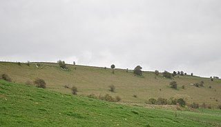
Grovely Castle is the site of an Iron Age univallate hill fort in the parish of Steeple Langford, in Wiltshire. The remaining ramparts stand approximately 3.2 m (10 ft) high, with 1.5 m (4.9 ft) deep ditches, although ploughing has damaged the earthworks in some parts of the site. Excavations have uncovered the remains of five human skeletons within the ramparts. Entrances are in the south-west and north-east corners of the hillfort. A circular enclosure of 35 to 40 m is evident in aerial photographs of the hillfort interior. There is also a later bank and ditch which runs through the hill-fort from south-west to north-east, and is probably part of an extensive surrounding Celtic field system.

<span class="mw-page-title-main">Shorn Cliff and Caswell Woods</span> Biological Site of Special Scientific Interest in Gloucestershire, England

Shorn Cliff And Caswell Woods is a 69.2-hectare (171-acre) biological Site of Special Scientific Interest in Gloucestershire, notified in 1986. The site is listed in the 'Forest of Dean Local Plan Review' as a Key Wildlife Site (KWS).

References

  1. Purple Emperor at ukbutterflies.co.uk
  2. 1 2 Crittall, Elizabeth, ed. (1959). "Victoria County History: Wiltshire: Vol 4 pp391-433 – Royal forests". British History Online. University of London. Retrieved 28 December 2016.
  3. Baggs, A.P.; Freeman, Jane; Stevenson, Janet H (1995). Crowley, D.A. (ed.). "Victoria County History: Wiltshire: Vol 15 pp284-294 – Great Wishford". British History Online. University of London. Retrieved 28 December 2016.
  4. Moonraking: The Folklore at bbc.co.uk
  5. "Wilton". Wiltshire Community History. Wiltshire Council. Retrieved 28 December 2016.
  6. Sarah (1 October 2020). "The Witches' Trees of Grovely Woods". Slow Travel. Retrieved 17 August 2022.
  7. The Gentleman's magazine, Volume 204, p. 72 online
  8. 'Proceedings at the Meetings of the Archaeological Institute, November 6, 1857' in The Archaeological Journal, Volume 15 (1858), p. 75 online
  9. John Britton; et al. (1814). The beauties of England and Wales, Vol 22. Verner & Hood. pp. 323–324.
  10. Oakley, Mike (2004). Wiltshire Railway Stations. Wimbourne: The Dovecote Press. pp. 154–155. ISBN   1-904349-33-1.
  11. "Groveley Wood". American Air Museum in Britain. Retrieved 18 March 2021.{{cite web}}: CS1 maint: url-status (link)

Coordinates: 51°06′25″N1°55′55″W / 51.107°N 1.932°W / 51.107; -1.932