History
The Guariba Extractive Reserve was created by Amazonas state governor decree 25.040 of 2 June 2005. The conservation unit is supported by the Amazon Region Protected Areas Program.
The Apuí Mosaic was created by decree 55 of 12 March 2010 under the responsibility of CEUC in the border region between the states of Amazonas, Mato Grosso and Pará. The mosaic contains the Guariba and Sucunduri State Parks; Bararati and Aripuanã sustainable development reserves; Guariba Extractive Reserve; and Sucunduri, Aripuanã, Apuí and Manicoré state forests. The Southern Amazon Mosaic of conservation units in the region between the states of Amazonas, Mato Grosso and Rondônia was recognised by the federal environment ministry by ordnance 332 of 25 August 2011. It includes the Guariba Extractive Reserve and other units of the Apuí Mosaic

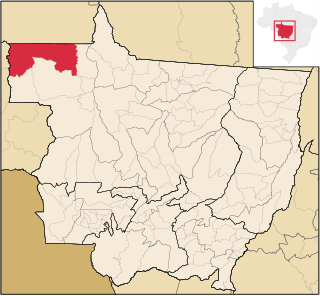
Apuí is a municipality located in the Brazilian state of Amazonas. Its population was 22,359 (2020) and its area is 54,240 km2.

Novo Aripuanã is a municipality located in the Brazilian state of Amazonas.
Colniza is a municipality in the state of Mato Grosso, Brazil.
Guariba River is a river of the Mato Grosso and Amazonas states in north-western Brazil. It is a tributary of the Aripuanã River.
Juruena National Park, declared in 2006, is the third largest national park of Brazil. It is located along the Juruena River, in the north of Mato Grosso state and the south of Amazonas state. It forms part of a corridor of protected areas that is meant to contain agricultural expansion into the Amazon rainforest.
The Rio Roosevelt Ecological Station is an ecological station in the state of Mato Grosso, Brazil.

The Campos Amazônicos National Park is a National park in the states of Rondônia, Amazonas and Mato Grosso, Brazil.
The Guariba-Roosevelt Extractive Reserve is an extractive reserve in the state of Mato Grosso, Brazil. A small traditional population live through fishing, hunting, small-scale agriculture and sale of forest products such as nuts. The reserve is under intense pressure from illegal logging and land grabbing.
Sucunduri State Park is a state park in the state of Amazonas, Brazil.
The Igarapés do Juruena State Park is a state park in the state of Mato Grosso, Brazil.
The Sucunduri State Forest is a state forest in the state of Amazonas, Brazil.
The Manicoré State Forest is a state forest in the state of Amazonas, Brazil.
The Aripuanã Sustainable Development Reserve is a sustainable development reserve in the state of Amazonas, Brazil.
The Aripuanã State Forest is a State forest in the state of Amazonas, Brazil.
The Apuí Mosaic is a protected area mosaic in the state of Amazonas, Brazil.
The Southern Amazon Mosaic is a protected area mosaic in Brazil.
The Guariba State Park is a State park in the state of Amazonas, Brazil.

The Maracanã Marine Extractive Reserve is a coastal marine extractive reserve in the state of Pará, Brazil. It protects an area of mangroves, and allows the local population to make sustainable use of the natural resources.
The Bararati Sustainable Development Reserve' is a sustainable development reserve in the state of Amazonas, Brazil.
The Apuí State Forest is a state forest in the state of Amazonas, Brazil.
This page is based on this
Wikipedia article Text is available under the
CC BY-SA 4.0 license; additional terms may apply.
Images, videos and audio are available under their respective licenses.
